La Sal Mountains

Last updated
La Sal Mountains
Mantilasalfromarches.jpg
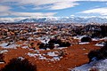
La Sal Mountains as seen from Arches National Park
Highest point
Peak Mount Peale
Elevation 12,721 ft (3,877 m)
Coordinates 38°26′19″N109°13′45″W / 38.43861°N 109.22917°W / 38.43861; -109.22917
Geography
USA Utah relief location map.svg
Red triangle with thick white border.svg
Location of the La Sal Range within Utah
CountryUnited States
StateUtah
Range coordinates 38°26′56″N109°14′28″W / 38.44889°N 109.24111°W / 38.44889; -109.24111
Parent range Rocky Mountains

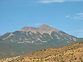
The La Sal Mountains or La Sal Range is a mountain range located in Grand and San Juan counties in the U.S. state of Utah, along the border with Colorado. The range rises above and southeast of Moab and north of the town of La Sal. This range is part of the Manti-La Sal National Forest and the southern Rocky Mountains. The maximum elevation is at Mount Peale, reaching 12,721 feet (3,877 m) above sea level.

Contents

The range contains three clusters of peaks separated by passes. The peaks span a distance of about 10 miles (16 km). The name of the range dates to Spanish times, when the Sierra La Sal (meaning the "Salt Mountains") was a prominent landmark on the Old Spanish Trail between Santa Fe and Los Angeles.

Geology

Mountain ranges associated with laccoliths and other igneous intrusions on part of the Colorado Plateau. The red dot marks the Four Corners, the intersection of Utah, Colorado, New Mexico, and Arizona. L, La Sal Mountains; A, Abajo Mountains; S, (Sleeping) Ute Mountain; C, Carrizo Mountains; N, Navajo Mountain; H, Henry Mountains. Plateau laccoliths NASA.jpg
Mountain ranges associated with laccoliths and other igneous intrusions on part of the Colorado Plateau. The red dot marks the Four Corners, the intersection of Utah, Colorado, New Mexico, and Arizona. L, La Sal Mountains; A, Abajo Mountains; S, (Sleeping) Ute Mountain; C, Carrizo Mountains; N, Navajo Mountain; H, Henry Mountains.

The range formed due to intrusion of igneous rocks and subsequent erosion of the surrounding less-resistant sedimentary rocks. The most abundant igneous rocks are porphyritic, with phenocrysts of hornblende and plagioclase: these rocks are called diorite in some accounts, but trachyte in at least one other source. Syenite, some containing the unusual mineral nosean, makes up a few percent of the igneous rocks present. Some igneous intrusions have the shapes of laccoliths. The ages of these igneous rocks fall between 25 and 28 million years. The magmas were emplaced into sedimentary rocks with ages from Permian to Cretaceous.

The La Sal Mountains rise high over the surrounding Colorado Plateau. Two other ranges on the Plateau, the Abajo Mountains and the Henry Mountains, formed around igneous intrusions of about the same age. Yet other nearby ranges, such as the Carrizo Mountains and Ute Mountain, formed about otherwise similar intrusions emplaced about 70 million years ago. The formation of these igneous rocks in two distinct time intervals has attracted the interest of scientists seeking explanations for magma production below relatively stable parts of the Earth's crust.

The La Sals at Sunset from Gemini Bridges Road LaSalMountains.jpg
The La Sals at Sunset from Gemini Bridges Road

Peaks of the La Sal Mountains

Little Tuk (left) and Mt. Tukuhnikivatz (right) of the La Sal Range in summer, seen from the south. A bare peak of La Sal.jpg
Little Tuk (left) and Mt. Tukuhnikivatz (right) of the La Sal Range in summer, seen from the south.
Winter view of Horse Mountain, looking east on the La Sal loop road, at Pinhook Valley, Utah Utah La Sal loop road in winter.jpg
Winter view of Horse Mountain, looking east on the La Sal loop road, at Pinhook Valley, Utah
The significant peaks of the La Sal Mountains are:
peak namefeet/meter
Mount Peale 12,721 feet (3,877 m)
Mount Mellenthin 12,645 feet (3,854 m)
Mount Tukuhnikivatz 12,482 feet (3,805 m)
Mount Waas 12,331 feet (3,758 m)
Manns Peak 12,272 feet (3,741 m)
Mount Laurel 12,271 feet (3,740 m)
Mount Tomasaki12,239 feet (3,730 m)
Pilot Mountain 12,200 feet (3,719 m)
Green Mountain12,163 feet (3,707 m)
Little Tuk12,048 feet (3,672 m)
Castle Peak12,044 feet (3,671 m)
La Sal Peak12,001 feet (3,658 m)

See also

Related Research Articles

<span class="mw-page-title-main">Colorado Plateau</span> Plateau in the Four Corners region of the southwestern United States

The Colorado Plateau, also known as the Colorado Plateau Province, is a physiographic and desert region of the Intermontane Plateaus, roughly centered on the Four Corners region of the southwestern United States. This province covers an area of 336,700 km2 (130,000 mi2) within western Colorado, northwestern New Mexico, southern and eastern Utah, northern Arizona, and a tiny fraction in the extreme southeast of Nevada. About 90% of the area is drained by the Colorado River and its main tributaries: the Green, San Juan, and Little Colorado. Most of the remainder of the plateau is drained by the Rio Grande and its tributaries.

<span class="mw-page-title-main">Laccolith</span> Mass of igneous rock formed from magma

A laccolith is a body of intrusive rock with a dome-shaped upper surface and a level base, fed by a conduit from below. A laccolith forms when magma rising through the Earth's crust begins to spread out horizontally, prying apart the host rock strata. The pressure of the magma is high enough that the overlying strata are forced upward, giving the laccolith its dome-like form.

<span class="mw-page-title-main">Abajo Mountains</span> Mountain range in San Juan County, Utah, USA

The Abajo Mountains, sometimes referred to as the Blue Mountains, are a small mountain range west of Monticello, Utah, south of Canyonlands National Park and north of Blanding, Utah. The mountain range is located within the Manti–La Sal National Forest. The highest point within the range is Abajo Peak at 11,360 feet (3,463 m).

<span class="mw-page-title-main">Henry Mountains</span> Mountain range in Utah, USA

The Henry Mountains is a mountain range located in the southeastern portion of the U.S. state of Utah that runs in a generally north-south direction, extending over a distance of about 30 miles (48 km). They were named by Almon Thompson in honor of Joseph Henry, the first secretary of the Smithsonian Institution. The nearest town of any size is Hanksville, Utah, which is north of the mountains. The Henry Mountains were the last mountain range to be added to the map of the 48 contiguous U.S. states (1872), and before their official naming by Thompson were sometimes referred to as the "Unknown Mountains." In Navajo, the range is still referred to as Dził Bizhiʼ Ádiní.

<span class="mw-page-title-main">Manti–La Sal National Forest</span>

The Manti–La Sal National Forest covers more than 1.2 million acres (4,900 km2) and is located in the central and southeastern parts of the U.S. state of Utah and the extreme western part of Colorado. The forest is headquartered in Price, with ranger district offices in Price, Ferron, Ephraim, Moab and Monticello. The maximum elevation is Mount Peale in the La Sal Mountains, reaching 12,721 feet (3,877 m) above sea level. The La Sal Mountains are the second highest mountain range in Utah after the Uintas. Parts of the forest are included in the Bears Ears National Monument.

<span class="mw-page-title-main">Ute Mountain</span> Mountain in Colorado, US

Ute Mountain, also known as Ute Peak or Sleeping Ute Mountain, is a peak within the Ute Mountains, a small mountain range in the southwestern corner of Colorado. It is on the northern edge of the Ute Mountain Ute Tribe Reservation. The Reservation forms the southwestern corner of the state and of Montezuma County.

<span class="mw-page-title-main">Navajo Mountain</span> Landform in Utah and Arizona, United States

Navajo Mountain is a peak in San Juan County, Utah, with its southern flank extending into Coconino County, Arizona, in the United States. It holds an important place in the traditions of three local Native American tribes. The summit is the highest point on the Navajo Nation.

<span class="mw-page-title-main">Carrizo Mountains</span> Landform in Apache County, Arizona

The Carrizo Mountains is a small, mostly circular mountain range 15 to 20 km in diameter located on the Colorado Plateau in northeastern Arizona. The range is about 20 km (12 mi) southwest of the Four Corners. The highest summit, Pastora Peak, is 2,869 m (9,413 ft) in elevation, whereas elevations on the surrounding plateau are near 1,800 m (5,900 ft).

<span class="mw-page-title-main">Igneous intrusion</span> Body of intrusive igneous rocks

In geology, an igneous intrusion is a body of intrusive igneous rock that forms by crystallization of magma slowly cooling below the surface of the Earth. Intrusions have a wide variety of forms and compositions, illustrated by examples like the Palisades Sill of New York and New Jersey; the Henry Mountains of Utah; the Bushveld Igneous Complex of South Africa; Shiprock in New Mexico; the Ardnamurchan intrusion in Scotland; and the Sierra Nevada Batholith of California.

<span class="mw-page-title-main">West Elk Mountains</span> Mountain in the state of Colorado

The West Elk Mountains are a high mountain range in the west-central part of the U.S. state of Colorado. They lie primarily within the Gunnison National Forest, and part of the range is protected as the West Elk Wilderness. The range is primarily located in Gunnison County, with small parts in eastern Delta and Montrose counties.

In geology, a chonolith is a type of igneous rock intrusion. Igneous rock intrusions are bodies of igneous rock that are formed by the crystallization of cooled magma below the Earth’s surface. These formations are termed intrusive rocks due the magma intruding rock layers but never reaching the earth’s surface. However, sometimes portions of plutons can become exposed at the Earth’s surface and thus the minerals can be observed since they are large enough. The different plutonic formations are named based on the different shapes that the cooled crystallized magma takes. However, all plutonic formations that have irregular shapes and do not share the same characteristics as other plutonic structures are termed chonoliths. Other plutonic structures that have specific shapes include: dikes, sills, laccoliths and sheets. Another unique characteristic of chonoliths is that there is a floor or base present which is typically absent in other types of intrusions.

<span class="mw-page-title-main">Tushar Mountains</span> Mountain range in Utah, United States

The Tushar Mountains are the third-highest mountain range in Utah after the Uinta Mountains and the La Sal Range. Located in the Fishlake National Forest, Delano Peak, 12,174 ft  NAVD 88, is the highest point in both Beaver and Piute counties and has a prominence of 4,689 ft. Delano Peak is named for Columbus Delano (1809–1896), Secretary of the Interior, during the Grant administration. The Tushars receive an ample amount of snow annually even though they are situated within the rainshadow of the Sierra Nevada range in California and the Snake Range located in Nevada.

<span class="mw-page-title-main">Crested Butte</span> Mountain in the state of Colorado

Crested Butte is a prominent mountain summit in the Elk Mountains range of the Rocky Mountains of North America. The 12,168-foot (3,709 m) peak is in Gunnison National Forest, 2.1 miles (3.4 km) northeast by east of the Town of Crested Butte in Gunnison County, Colorado, United States. Ski lifts and runs of the Crested Butte Mountain Resort occupy the north side of the mountain.

<span class="mw-page-title-main">Igneous rock</span> Rock formed through the cooling and solidification of magma or lava

Igneous rock, or magmatic rock, is one of the three main rock types, the others being sedimentary and metamorphic. Igneous rocks are formed through the cooling and solidification of magma or lava.

<span class="mw-page-title-main">Tomichi Dome</span> Igneous mountain in the state of Colorado

Tomichi Dome rises north of U.S. Highway 50 west of Hot Springs Creek and south of Waunita Hot Springs Reservoir in the southeast quarter of Gunnison County, Colorado. It is situated within the Gunnison National Forest.

<span class="mw-page-title-main">Carbon Peak</span> Mountain in Colorado, United States

Carbon Peak, elevation 12,088 ft (3,684 m), is a summit in the West Elk Mountains of Colorado. The peak is southwest of Crested Butte in the Gunnison National Forest. Carbon Peak is one of several prominent laccoliths found in the West Elk Mountains.

<span class="mw-page-title-main">West Beckwith Mountain</span> Mountain in Colorado, USA

West Beckwith Mountain is a prominent mountain summit in the West Elk Mountains range of the Rocky Mountains of North America. The 12,185-foot (3,714 m) peak is located in the West Elk Wilderness of Gunnison National Forest, about 16.5 miles (26.5 km) southwest of Crested Butte in Gunnison County, Colorado, United States.

<span class="mw-page-title-main">Anthracite Range</span> Mountain range in Colorado, United States

The Anthracite Range is a mountain range in the West Elk Mountains, a sub-range of the Rocky Mountains of North America. The range is located in Gunnison County of western Colorado and lies within the West Elk Wilderness of the Gunnison National Forest. The Anthracite Range is one of several prominent laccoliths found in the West Elk Mountains.

<span class="mw-page-title-main">Central Montana Alkalic Province</span> Geologic area in Montana

The central Montana Alkalic Province is located in the United States in central Montana. Montana is bordered by Idaho, Wyoming, North Dakota, South Dakota, and Canada to the north. Central Montana is unique when compared to the rest of the Rocky Mountains due to its east-west trend of tectonic features, including thrust fault zones, anticlines, and domes. The area of tectonic activity experienced conditions of plastic deformation, which affected the whole region. The Montana Alkalic Province consist of Cretaceous intrusions of monzonite and syenite as well as Cambrian limestone, sandstone, and siltstone. Most of the sedimentary rocks are a result of deposition from a terrestrial fluvial environment. Deposition included more than 13,000 feet of clastics that were later uplifted. The peak of this uplifting occurred during the Devonian. Deposition, uplift, and traps of carbonate shales have made central Montana prime for small-scale oil and gas production. Other geologic formations in this area include Judith Mountains, Crazy Mountains, Highwood Mountains, and Bears Paw Mountains. These areas include various igneous formations including xenoliths, laccoliths, and veins. Each mountain exhibits similar but unique geologic features.

<span class="mw-page-title-main">Volcanic and igneous plumbing systems</span> Magma chambers

Volcanic and igneous plumbing systems (VIPS) consist of interconnected magma channels and chambers through which magma flows and is stored within Earth's crust. Volcanic plumbing systems can be found in all active tectonic settings, such as mid-oceanic ridges, subduction zones, and mantle plumes, when magmas generated in continental lithosphere, oceanic lithosphere, and in the sub-lithospheric mantle are transported. Magma is first generated by partial melting, followed by segregation and extraction from the source rock to separate the melt from the solid. As magma propagates upwards, a self-organised network of magma channels develops, transporting the melt from lower crust to upper regions. Channelled ascent mechanisms include the formation of dykes and ductile fractures that transport the melt in conduits. For bulk transportation, diapirs carry a large volume of melt and ascent through the crust. When magma stops ascending, or when magma supply stops, magma emplacement occurs. Different mechanisms of emplacement result in different structures, including plutons, sills, laccoliths and lopoliths.

References

Jules D. Friedman and A. Curtis Huffman Jr., Coordinators, Laccolith Complexes of Southeastern Utah: Time of Emplacement and Tectonic Setting—Workshop Proceedings, United States Geological Survey Bulletin 2158, 292 pages, 1998. http://pubs.usgs.gov/bul/b2158/B2158.pdf