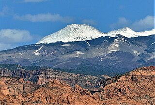
The La Sal Mountains or La Sal Range is a mountain range located in Grand and San Juan counties in the U.S. state of Utah, along the border with Colorado. The range rises above and southeast of Moab and north of the town of La Sal. This range is part of the Manti-La Sal National Forest and the southern Rocky Mountains. The maximum elevation is at Mount Peale, reaching 12,721 feet (3,877 m) above sea level.

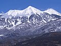
Mount Peale is the highest point in the La Sal Mountains of San Juan County, in the southeastern part of Utah, United States. It is also the highest point in Utah outside the Uinta Mountains. It is located about 20 mi (32 km) southeast of Moab. The summit is the highest point in the Manti-La Sal National Forest and the Mount Peale Research Natural Area. Mount Peale was named for Albert Peale, a mineralogist on the Hayden Survey of 1875.

South Mountain is an 11,798-foot (3,596 m) peak in San Juan County, Utah in the United States, about 5 miles (8.0 km) north of La Sal, Utah. It is part of the La Sal Mountains. Precipitation runoff from this mountain drains into tributaries of the Colorado River. The nearest town is Moab, 20 mi (32 km) to the northwest, and the nearest higher neighbor is Mount Tukuhnikivatz, 2.64 mi (4.25 km) to the north.

Mount Spry is a small 5,720-ft elevation mountain summit made of Navajo Sandstone located in Zion National Park, in Washington County of southwest Utah, United States. Officially named in 1934, it honors William Spry (1864–1929), the third governor of Utah. The nearest higher peak is The East Temple, 0.34 miles (0.55 km) to the east. Precipitation runoff from the mountain drains into tributaries of the North Fork Virgin River.

Mount Fricaba is a 7,139-foot-elevation (2,176 m) double summit mountain located in the Olympic Mountains, in Jefferson County of Washington state. It is situated on the shared border of Olympic National Park with Buckhorn Wilderness, and is the highest point in that wilderness, as well as the Olympic National Forest. Its nearest higher peak is Hal Foss Peak, 0.74 miles (1.19 km) to the southwest. Precipitation runoff from the peak drains east into headwaters of the Dungeness River, or west into Deception Creek which is a tributary of the Dosewallips River. The mountain's name was officially adopted in 1961 by the United States Board on Geographic Names based on usage by The Mountaineers since 1907, and inclusion in Fred Beckey's "Climber's Guide to the Cascade and Olympic Mountains of Washington" published in 1949. The first ascent of the mountain was made in 1957 by Don Bechlem and Jack Newman.
Mount Worthington is a 6,938-foot (2,115-metre) elevation double-summit mountain located in the eastern Olympic Mountains in Jefferson County of Washington state. It is set within Buckhorn Wilderness, on land managed by the Olympic National Forest. The nearest neighbor is Iron Mountain, 0.76 mi (1.22 km) to the southwest, and the nearest higher peak is Buckhorn Mountain, 1.3 mi (2.1 km) to the southwest. Precipitation runoff from Mount Worthington drains south into the Big Quilcene River, or north into Copper Creek which is a tributary of the Dungeness River. This mountain was first known as Copper Peak, but was renamed by Jack Christensen for the William J. Worthington family, pioneers of nearby Quilcene. Copper was mined in the Tubal Cain mine at the northern base of this mountain in the early 1900s. In the same vicinity of the abandoned mine are the remains of a modified B-17 plane that crashed on January 19, 1952, when returning from a search-and-rescue mission.
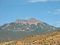
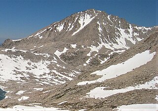
Mount Mellenthin is a 12,645-foot elevation summit located in San Juan County of Utah, United States. Mount Mellenthin is the second-highest peak of the La Sal Mountains, and second-highest in the county. It is situated in a dry, rugged, sparsely settled region, and set on land administered by Manti-La Sal National Forest. Precipitation runoff from this mountain drains into tributaries of the Colorado River. The nearest town is Moab, 20 mi (32 km) to the northwest, and the nearest higher neighbor is Mount Peale, 1.7 mi (2.7 km) to the south. The mountain's name honors Rudolf E. Mellenthin (1884–1918), forest ranger of La Sal National Forest, who was shot to death near this peak on August 23, 1918, while attempting to apprehend two draft evaders. This geographical feature's toponym was officially adopted in 1932 by the U.S. Board on Geographic Names.

Mount Thompson is a 13,494-foot-elevation mountain summit located on the crest of the Sierra Nevada mountain range in California, United States. It is situated on the shared boundary of Kings Canyon National Park with John Muir Wilderness, and along the common border of Fresno County with Inyo County. It is also 18 miles (29 km) west of the community of Big Pine, one mile northwest of Mount Gilbert, and three miles east of Mount Fiske, which is the nearest higher neighbor. Mount Thompson ranks as the 62nd-highest summit in California. This mountain's name commemorates Almon Harris Thompson (1839–1906). The first ascent of the peak was made by Clarence H. Rhudy and H. F. Katzenbach in the summer of 1909.

Mount Warlow is a 13,206-foot-elevation mountain summit located 1.5 miles (2.4 km) west of the crest of the Sierra Nevada mountain range, in Fresno County of northern California, United States. It is situated on the Goddard Divide in northern Kings Canyon National Park, 1.2 miles (1.9 km) north of Muir Pass, 0.69 miles (1.11 km) southeast of Mount Huxley, and 0.68 miles (1.09 km) southwest of Mount Fiske, which is the nearest higher neighbor. Mount Warlow ranks as the 108th highest summit in California. The approach to this remote peak is made via the John Muir Trail.
Mount Hilgard is a 13,361-foot-elevation (4,072 meter) mountain summit located west of the crest of the Sierra Nevada mountain range in Fresno County of northern California, United States. It is situated in the John Muir Wilderness on land managed by Sierra National Forest, approximately eight miles east-southeast of Lake Thomas A Edison, and immediately above the west end of Lake Italy. The nearest higher neighbor is Mount Gabb, 1.75 miles (2.82 km) to the northeast, and Recess Peak is 2.2 miles (3.5 km) to the northwest. The John Muir Trail follows Bear Creek to the west of this remote peak, providing an approach. Mt. Hilgard ranks as the 82nd highest summit in California.

Carson Peak is a 10,908-foot-elevation (3,325-meter) mountain summit located in the Sierra Nevada mountain range, in Mono County of northern California, United States. It is situated in the Ansel Adams Wilderness, on land managed by Inyo National Forest. It is approximately 3.5 miles (5.6 km) southwest of the community of June Lake, 2.0 miles (3.2 km) south of Silver Lake, and 2.25 miles (3.62 km) northwest of San Joaquin Mountain, the nearest higher neighbor. The mountain is visible from various locations along the June Lake Loop, and from the nearby June Mountain ski area. The summit offers impressive views of Mount Ritter and Banner Peak. Topographic relief is significant as it rises 3,700 feet above the valley in 1.2 mile. The mountain consists of granite of Lee Vining Canyon. Carson Peak is considered an eastern Sierra classic by backcountry skiers drawn to routes called the "Devils Slide" and "Petes Dream".

Mount Emma is a 13,581-foot-elevation (4,139-meter) mountain summit located in San Miguel County of Colorado, United States. It is situated three miles north of the community of Telluride, on the south side of Yankee Boy Basin, in the Uncompahgre National Forest. It is part of the Sneffels Range which is a subset of the San Juan Mountains, which in turn is part of the Rocky Mountains. Mount Emma is situated west of the Continental Divide, two miles south of Mount Sneffels, and 0.8 mile south of Gilpin Peak, the nearest higher neighbor. Emma ranks as the 197th-highest peak in Colorado, and the 10th-highest in the Sneffels Range. Topographic relief is significant as the south aspect rises 4,830 feet above Telluride in approximately three miles. An ascent of Mt. Emma is a difficult climb with 2,180 feet of elevation gain covering three miles from Yankee Boy Basin, or 4,836 feet of elevation gain from Telluride. This mountain's name was officially adopted by the U.S. Board on Geographic Names.

Cirque Mountain is a 13,686-foot-elevation (4,171-meter) mountain summit located in Ouray County of southwest Colorado, United States. It is situated six miles west of the community of Ouray, above the north side of Yankee Boy Basin, on land managed by Uncompahgre National Forest. It is part of the Sneffels Range which is a subset of the San Juan Mountains, which in turn is part of the Rocky Mountains. Cirque ranks as the 155th-highest peak in Colorado, and the ninth-highest in the Sneffels Range. It is west of the Continental Divide, 1.12 mile east of Mount Sneffels, and 0.59 mile west of Teakettle Mountain, which is the nearest higher neighbor. Topographic relief is significant as the north aspect rises 3,000 feet above Blaine Basin in one mile, and the south aspect rises over 2,000 feet above Yankee Boy Basin in less than one mile. These basins are cirques which were carved by ancient glaciers. The mountain's name has been officially adopted by the United States Board on Geographic Names.

Jefferson Peak is a 5,720-foot (1,743 m) mountain summit located in the Olympic Mountains in Mason County of Washington state. It is situated in the Mount Skokomish Wilderness, on land managed by Olympic National Forest. The mountain's toponym honors Thomas Jefferson (1743–1826), the third president of the United States. The nearest higher neighbor is line parent Mount Pershing, 1.3 mi (2.1 km) to the southwest. Precipitation runoff drains into Jefferson Creek and the Hamma Hamma River. Topographic relief is significant as the north aspect rises over 4,100 feet (1,200 m) above the Hamma Hamma valley in approximately one mile.
Mount Ann is a 5,840-foot-elevation (1,780-meter) mountain summit located in the North Cascades in Whatcom County of Washington state. It is set within the Mount Baker Wilderness, on land managed by Mount Baker-Snoqualmie National Forest, and is only one mile outside the boundary of North Cascades National Park. Mount Ann is situated immediately southwest of line parent Mount Shuksan and northeast of Mount Baker. Mount Ann can be seen south of Artist Point which is at the end of the Mount Baker Highway. Precipitation runoff from the mountain drains into Swift Creek and Shuksan Creek, which empty into Baker Lake. Topographic relief is significant as the west aspect rises 3,200 feet above Swift Creek in approximately one mile. The mountain is unofficially named in association with nearby Lake Ann. Due to its proximity to the Mt. Baker Ski Area, Mount Ann is a winter destination for skiing and snowshoeing.

Little Devil Peak is a 6,985-foot-elevation (2,129 m) mountain summit located in Skagit County of Washington state. It is set within North Cascades National Park and Stephen Mather Wilderness, where it is situated 3.1 miles northeast of Lookout Mountain. Little Devil is the second-highest peak of Teebone Ridge, and other peaks on this ridge include line parent Big Devil Peak, Fallen Angel, and The Trapezoid. Precipitation runoff from the mountain drains into tributaries of the Skagit River. Like many North Cascades peaks, it is more notable for its large, steep rise above local terrain than for its absolute elevation. Topographic relief is significant as the south aspect rises 5,400 feet above Marble Creek in three miles, and the east aspect rises 4,200 feet above Newhalem Creek in approximately 1.5 mile.

Mount Warren is a 12,327-foot-elevation (3,757 meter) summit located in the Sierra Nevada mountain range, in Mono County, California, United States. The mountain is set within the Hoover Wilderness, on land managed by Inyo National Forest. The peak is situated 1.5 miles (2.4 km) south of Gilcrest Peak, 1.8 miles (2.9 km) northwest of Lee Vining Peak, and 5 miles (8.0 km) southeast of Excelsior Mountain, which is the nearest higher neighbor. Topographic relief is significant as the summit rises 5,955 feet above Mono Lake in 4.5 miles.

Apache Peak is a 13,441-foot (4,097 m) mountain summit on the boundary shared by Boulder County and Grand County, in Colorado, United States.

Box Elder Peak is an 11,101-foot-elevation (3,384-meter) mountain summit located in Utah County, Utah, United States.

Mount Wolverine is a 10,795-foot-elevation (3,290-meter) summit in Salt Lake County, Utah, United States.