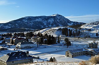
Yellowstone National Park is a national park located in the western United States, largely in the northwest corner of Wyoming and extending into Montana and Idaho. It was established by the 42nd U.S. Congress with the Yellowstone National Park Protection Act and signed into law by President Ulysses S. Grant on March 1, 1872. Yellowstone was the first national park in the U.S. and is also widely held to be the first national park in the world. The park is known for its wildlife and its many geothermal features, especially the Old Faithful geyser, one of its most popular. While it represents many types of biomes, the subalpine forest is the most abundant. It is part of the South Central Rockies forests ecoregion.

Green River is a city in Emery County, Utah, United States. The population was 847 at the 2020 census.

James Felix Bridger was an American mountain man, trapper, Army scout, and wilderness guide who explored and trapped in the Western United States in the first half of the 19th century. He was known as Old Gabe in his later years. He was from the Bridger family of Virginia, English immigrants who had been in North America since the early colonial period.

The Green River, located in the western United States, is the chief tributary of the Colorado River. The watershed of the river, known as the Green River Basin, covers parts of the U.S. states of Wyoming, Utah, and Colorado. The Green River is 730 miles (1,170 km) long, beginning in the Wind River Mountains of Wyoming and flowing through Wyoming and Utah for most of its course, except for a short segment of 40 miles (64 km) in western Colorado. Much of the route traverses the arid Colorado Plateau, where the river has carved some of the most spectacular canyons in the United States. The Green is slightly smaller than Colorado when the two rivers merge but typically carries a larger load of silt. The average yearly mean flow of the river at Green River, Utah is 6,121 cubic feet (173.3 m3) per second.

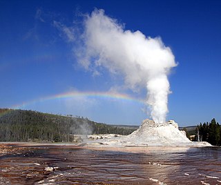
Castle Geyser is a cone geyser in the Upper Geyser Basin of Yellowstone National Park. It is noted for the particularly large geyserite sinter deposits, which form its cone. These deposits have been likened in appearance to a castle.

Craig Pass, is a mountain pass located on the Continental Divide in Yellowstone National Park in Wyoming, United States. The Grand Loop Road crosses the pass approximately 8 miles (13 km) east of Old Faithful Geyser.

The Manti–La Sal National Forest covers more than 1.2 million acres (4,900 km2) and is located in the central and southeastern parts of the U.S. state of Utah and the extreme western part of Colorado. The forest is headquartered in Price, with ranger district offices in Price, Ferron, Ephraim, Moab and Monticello. The maximum elevation is Mount Peale in the La Sal Mountains, reaching 12,721 feet (3,877 m) above sea level. The La Sal Mountains are the second highest mountain range in Utah after the Uintas. Parts of the forest are included in the Bears Ears National Monument.

The La Sal Mountains or La Sal Range is a mountain range located in Grand and San Juan counties in the U.S. state of Utah, along the border with Colorado. The range rises above and southeast of Moab and north of the town of La Sal. This range is part of the Manti-La Sal National Forest and the southern Rocky Mountains. The maximum elevation is at Mount Peale, reaching 12,721 feet (3,877 m) above sea level.
The 1959 Hebgen Lake earthquake occurred in the western United States on August 17 at 11:37 pm (MST) in southwestern Montana.

Big Sulphur Creek is a westward-flowing stream in northern Sonoma County, California, United States, which springs from The Geysers in the Mayacamas Mountains and runs 20 miles (32 km) to empty into the Russian River.

The Dinosaur Diamond is a 486-mile (782 km) scenic and historic byway loop through the dinosaur fossil laden Uinta Basin of the U.S. states of Utah and Colorado. The byway comprises the following two National Scenic Byways:

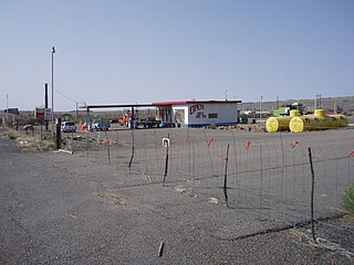
Woodside is a ghost town located on the west bank of the shallow Price River in the nearly uninhabited eastern part of Emery County, Utah, United States. Its fenced-in filling station is one of the only signs of human activity along the lonely stretch of U.S. Route 6/191 between Wellington and Green River.

The following is an alphabetical list of articles related to the U.S. state of Wyoming.

The following is an alphabetical list of articles related to the U.S. state of Utah.

The following articles relate to the history, geography, geology, flora, fauna, structures and recreation in Yellowstone National Park.

Bunsen Peak el. 8,564 feet (2,610 m) is a prominent peak due south of Mammoth Hot Springs in Yellowstone National Park, Wyoming. The peak lies on the east flank of Kingman Pass on the Mammoth to Norris section of the Grand Loop Road. The peak was first ascended by Ferdinand V. Hayden and Captain John W. Barlow in 1871, Bunsen Peak was not named until 1872 during the second Hayden Geologic Survey. E. S. Topping named the peak Observation Mountain in 1872 as well, but that name did not stick. The Bunsen Peak Trail with its trailhead just south of Mammoth is a steep 2.1 miles (3.4 km) to the summit. Bunsen Peak was named for the German chemist Robert Bunsen, the inventor of the Bunsen Burner and responsible for early work on volcanic geyser theories.

Shoshone Lake is a U.S. backcountry lake with an area of 8,050 acres with an elevation of 7,795 feet (2,376 m) in the southwest section of Yellowstone National Park, Wyoming. It lies at the headwaters of the Lewis River, a tributary of the Snake River. The U.S. Fish and Wildlife Service believes that Shoshone Lake is the largest backcountry lake in the lower 48 states that cannot be reached by a road. The Yellowstone Caldera is located within the lake.

Factory Hill el. 9,527 feet (2,904 m) is a mountain peak in the Red Mountains of Yellowstone National Park. It is directly north of Mount Sheridan and west of the Heart Lake Geyser Basin. Early in the history of Yellowstone, this peak was called Red Mountain by the Hayden surveys, a name later transferred to the range in which it resides. In 1885, the Hague Geological Survey gave the peak its present name based on the following passage by Nathaniel P. Langford in his 1871 Scribner's account of the Washburn–Langford–Doane Expedition. Langford's party was camped near the south arm of Yellowstone Lake at the time.
Semi-Centennial Geyser is located just north of Roaring Mountain in Yellowstone National Park in the U.S. state of Wyoming. Situated next to the Grand Loop Road, the geyser was first noticed when it had a few small eruptions in 1919. A few years later at 6:40am on August 14, 1922 the geyser erupted in the first of a series of increasingly violent eruptions. By the afternoon on the same day reports stated that the ejected water was exceeding 300 feet (91 m) in height. By the evening of the 14th, the geyser had scattered debris and rocks a distance of 450 ft (140 m) from the crater. Short lived, Semi-Centennial Geyser has been quiet since and a small pool of water now exists where the geyser erupted. As the geyser showed its biggest activity in 1922, the 50th anniversary of the establishment of Yellowstone National Park in 1872, it was accorded the name of Semi-Centennial.


