
The San Juan Mountains is a high and rugged mountain range in the Rocky Mountains in southwestern Colorado and northwestern New Mexico. The area is highly mineralized and figured in the gold and silver mining industry of early Colorado. Major towns, all old mining camps, include Creede, Lake City, Silverton, Ouray, and Telluride. Large scale mining has ended in the region, although independent prospectors still work claims throughout the range. The last large scale mines were the Sunnyside Mine near Silverton, which operated until late in the 20th century and the Idarado Mine on Red Mountain Pass that closed down in the 1970s. Famous old San Juan mines include the Camp Bird and Smuggler Union mines, both located between Telluride and Ouray.

Ouray is a home rule municipality that is the county seat of Ouray County, Colorado, United States. The city population was 1,000 as of the 2010 census. The Ouray Post Office has the ZIP code 81427. Ouray's climate, natural alpine environment, and scenery has earned it the nickname, "Switzerland of America".
U.S. Route 550 (US 550) is a spur of U.S. Highway 50 that runs from Bernalillo, New Mexico to Montrose, Colorado in the western United States. The section from Silverton to Ouray is frequently called the Million Dollar Highway. It is one of the roads on the Trails of the Ancients Byway, one of the designated New Mexico Scenic Byways.

The Cutler Formation or Cutler Group is a rock unit that is exposed across the U.S. states of Arizona, northwest New Mexico, southeast Utah and southwest Colorado. It was laid down in the Early Permian during the Wolfcampian epoch.

The Weminuche Wilderness is a wilderness area in southwest Colorado managed by the United States Forest Service as part of the San Juan National Forest on the west side of the Continental Divide and the Rio Grande National Forest on the east side of the divide. The Weminuche Wilderness was designated by Congress in 1975, and expanded by the Colorado Wilderness Acts of 1980 and 1993. It is located 4 miles (6.4 km) southeast of the town of Silverton, 17 miles (27 km) northeast of Durango, and 8 miles (13 km) west of South Fork. At 499,771 acres (2,022.50 km2), it is the largest wilderness area in the state of Colorado. Elevation in the wilderness ranges from 7,700 feet (2,300 m) along the Animas River to 14,093 feet (4,296 m) at the summit of Windom Peak.

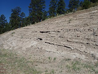
The Mancos Shale or Mancos Group is a Late Cretaceous geologic formation of the Western United States.

The Unkar Group is a sequence of strata of Proterozoic age that are subdivided into five geologic formations and exposed within the Grand Canyon, Arizona, Southwestern United States. The 5-unit Unkar Group is the basal member of the 8-member Grand Canyon Supergroup. The Unkar is about 1,600 to 2,200 m thick and composed, in ascending order, of the Bass Formation, Hakatai Shale, Shinumo Quartzite, Dox Formation, and Cardenas Basalt. Units 4 & 5 are found mostly in the eastern region of Grand Canyon. Units 1 through 3 are found in central Grand Canyon. The Unkar Group accumulated approximately between 1250 and 1104 Ma. In ascending order, the Unkar Group is overlain by the Nankoweap Formation, about 113 to 150 m thick; the Chuar Group, about 1,900 m (6,200 ft) thick; and the Sixtymile Formation, about 60 m (200 ft) thick. These are all of the units of the Grand Canyon Supergroup. The Unkar Group makes up approximately half of the thickness of the 8-unit Supergroup.

The Hakatai Shale is a Mesoproterozoic rock formation with important exposures in the Grand Canyon, Coconino County, Arizona. It consists of colorful strata that exhibit colors varying from purple to red to brilliant orange. These colors are the result of the oxidation of iron-bearing minerals in the Hakatai Shale. It consists of lower and middle members that consist of bright-red, slope-forming, highly fractured, argillaceous mudstones and shale and an upper member composed of purple and red, cliff-forming, medium-grained sandstone. Its thickness, which apparently increases eastwards, varies from 137 to 300 m. In general, the Hakatai Shale and associated strata of the Unkar Group rocks dip northeast (10–30°) toward normal faults that dip 60° or more toward the southwest. This can be seen at the Palisades fault in the eastern part of the main Unkar Group outcrop area. In addition, thick, prominent, and dark-colored basaltic sills and dikes cut across the purple to red to brilliant orange strata of the Hakatai Shale.

The Bass Formation, also known as the Bass Limestone, is a Mesoproterozoic rock formation that outcrops in the eastern Grand Canyon, Coconino County, Arizona. The Bass Formation erodes as either cliffs or stair-stepped cliffs. In the case of the stair-stepped topography, resistant dolomite layers form risers and argillite layers form steep treads. In general, the Bass Formation in the Grand Canyon region and associated strata of the Unkar Group-rocks dip northeast (10°–30°) toward normal faults that dip 60+° toward the southwest. This can be seen at the Palisades fault in the eastern part of the main Unkar Group outcrop area. In addition, thick, prominent, and dark-colored basaltic sills intrude across the Bass Formation.

The Vadito Group is a group of geologic formations that crops out in most of the Precambrian-cored uplifts of northern New Mexico. Detrital zircon geochronology and radiometric dating give a consistent age of 1700 Mya for the group, corresponding to the Statherian period.

The Ortega Formation is a geologic formation that crops out in most of the mountain ranges of northern New Mexico. Detrital zircon geochronology establishes a maximum age for the formation of 1690-1670 million years (Mya), in the Statherian period of the Precambrian.
The Los Pinos Formation is a geologic formation in northern New Mexico. It was deposited from the late Oligocene through the late Miocene epochs, based on radiometric ages of interbedded lava flows and overlying and underlying formations.

Blue Mesa Summit is a mountain pass in Gunnison County of west-central Colorado. The pass is traversed by U.S. Route 50 and divides the watersheds of Little Cimarron River to the west and Blue Creek to the east.

Electric Peak is a 13,292-foot-elevation mountain summit located in San Juan County, Colorado, United States. It is situated eight miles south of the community of Silverton, in the Weminuche Wilderness, on land managed by San Juan National Forest. It is part of the Needle Mountains which are a subset of the San Juan Mountains, which in turn is a subset of the Rocky Mountains. Precipitation runoff from the mountain drains into tributaries of the Animas River. The peak can be seen from U.S. Route 550 and the Durango and Silverton Narrow Gauge Railroad. Topographic relief is significant as the west aspect rises over 4,500 feet (1,370 meters) above the river and railway in approximately two miles. It is set five miles west of the Continental Divide, and one mile east of Mount Garfield. The mountain's name, which has been officially adopted by the United States Board on Geographic Names, was in use before 1906 when Henry Gannett published it in the Gazetteer of Colorado.

Wildhorse Peak is a 13,266-foot-elevation (4,043 meter) mountain summit located in Ouray County, of Colorado, United States. It is situated five miles east of the community of Ouray, in the Uncompahgre Wilderness, on land managed by Uncompahgre National Forest. It is part of the San Juan Mountains which are a subset of the Rocky Mountains, and is situated west of the Continental Divide. Neighbors include Darley Mountain 2.2 miles to the south, and Abrams Mountain five miles to the southwest. This distinctive peak abruptly rises 1,000 feet above the alpine tundra of American Flats, and topographic relief is significant as the northwest aspect rises 1,600 feet (488 meters) above Wildhorse Creek in less than one mile. The peak can be seen from Montrose and Highway 550. The first ascent of the summit was made August 25, 1899, by Eli Stanton, F. H. Stanton, and William Killen. The mountain's name, which has been officially adopted by the United States Board on Geographic Names, was in use in 1906 when Henry Gannett published it in A Gazetteer of Colorado.

Hurricane Peak is a 13,447-foot-elevation mountain summit located in San Juan County of southwest Colorado, United States. It is situated equidistant between the historic towns of Ouray and Silveton, and is approximately nine miles west of the Continental Divide. It is part of the San Juan Mountains which are a subset of the Rocky Mountains. Topographic relief is significant as the north aspect rises 1,200 feet (365 meters) above Lake Como in one-half mile. Neighbors include Abrams Mountain 3.4 miles to the north, and Red Mountain 2.2 miles to the west. The Mountain Queen Mine, which is located on the east slope of Hurricane Peak at the head of California Gulch, is one of the oldest workings in the area and was most active from 1878 to 1880. The mountain's name, which has been officially adopted by the United States Board on Geographic Names, was in use in 1906 when Henry Gannett published it in the Gazetteer of Colorado.

Ulysses S Grant Peak is a 13,767-foot-elevation mountain summit located on the shared boundary of San Juan County with San Miguel County, in southwest Colorado, United States. It is situated eight miles west of the community of Silverton, on land managed by San Juan National Forest and Uncompahgre National Forest. Ulysses S Grant Peak is part of the San Juan Mountains which are a subset of the Rocky Mountains, and is west of the Continental Divide. It ranks as the 119th-highest peak in Colorado, and topographic relief is significant as the west aspect rises 2,400 feet (730 meters) in approximately one mile. The mountain's name, which has been officially adopted by the United States Board on Geographic Names, was in use in an 1896 scientific publication by Charles Whitman Cross, and listed by Henry Gannett when he published A Gazetteer of Colorado in 1906.

The Ignacio Formation is a geologic formation that crops out in the San Juan Mountains of southwestern Colorado. Long thought to be Cambrian in age, the formation is now thought to be upper Devonian in age, based on detrital zircon geochronology and other evidence.
The Elbert Formation is a geologic formation that crops out in the San Juan Mountains of southwestern Colorado. The formation contains fossils indicating it is upper Devonian in age.
The Molas Formation is a geologic formation that is found in the Four Corners region of the United States. Its age is poorly constrained but is thought to be Namurian.
