Mount Stratus

Last updated
Mount Stratus
Mts. Stratus and Nimbus.jpg
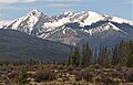
Northeast aspect of Mount Stratus at upper left
(Mount Nimbus to the right)
Highest point
Elevation 12,534 ft (3,820 m) [1]
Prominence 139 ft (42 m) [1]
Parent peak Mount Nimbus (12,721 ft) [1]
Isolation 0.44 mi (0.71 km) [1]
Coordinates 40°23′25″N105°54′13″W / 40.3902062°N 105.9035290°W / 40.3902062; -105.9035290 [2]
Naming
Etymology Stratus cloud
Geography
USA Colorado relief location map.svg
Red triangle with thick white border.svg
Mount Stratus
Location in Colorado
Usa edcp relief location map.png
Red triangle with thick white border.svg
Mount Stratus
Mount Stratus (the United States)
CountryUnited States
State Colorado
County Grand County
Protected area Rocky Mountain National Park
Never Summer Wilderness
Parent range Rocky Mountains
Never Summer Mountains
Topo map USGS Mount Richthofen [3]
Geology
Type of rock Biotite Gneiss and Schist [4]
Climbing
Easiest route class 2 West slope or North ridge [5]

Mount Stratus is a 12,534-foot-elevation (3,820-meter) mountain summit in Grand County, Colorado, United States.

Contents

Description

Mount Stratus is the ninth-highest peak of the Never Summer Mountains which are a subrange of the Rocky Mountains. [6] The mountain is situated on the western boundary of Rocky Mountain National Park and is visible from Trail Ridge Road within the park. The west side of the peak is in the Never Summer Wilderness which is managed by Arapaho National Forest. Precipitation runoff from the mountain's slopes drains into tributaries of the Colorado River except for a portion which is diverted by the Grand Ditch. Topographic relief is significant as the summit rises 3,600 feet (1,100 meters) above the Kawuneeche Valley in 2.5 miles (4.0 km) and 1,700 feet (520 meters) above Baker Gulch in three-quarters of a mile. An ascent of the peak involves hiking 12.8 miles (20.6 km) round-trip with 3,555 feet (1,084 m) of elevation gain. [7]

Etymology

The mountain's toponym has been officially adopted by the United States Board on Geographic Names. [2] [8] In 1914, James Grafton Rogers named Mount Cirrus, Mount Nimbus, and Mount Cumulus for different types of common clouds, but he did not name Mt. Stratus, it was added later. [9]

Climate

According to the Köppen climate classification system, Mount Nimbus is located in an alpine subarctic climate zone with cold, snowy winters, and cool to warm summers. [10] Due to its altitude, it receives precipitation all year, as snow in winter, and as thunderstorms in summer, with a dry period in late spring.

See also

Related Research Articles

<span class="mw-page-title-main">Never Summer Mountains</span> Mountain range in Colorado, US

The Never Summer Mountains are a mountain range in the Rocky Mountains in north central Colorado in the United States consisting of seventeen named peaks. The range is located along the northwest border of Rocky Mountain National Park, forming the continental divide between the headwaters of the Colorado River in Rocky Mountain National Park to the local-east and the upper basin of the North Platte River to the local-west; the continental divide makes a loop in these mountains. The range is small and tall, covering only 25 sq mi (65 km2) with a north–south length of 10 mi (16 km) while rising to over 12,000 ft (3,700 m) at over ten distinct peaks. The range straddles the Jackson-Grand county line for most of its length, and stretches into Jackson and Larimer county at its northern end. A panoramic view of the range is available from sections of Trail Ridge Road in Rocky Mountain National Park. One of the northernmost peaks, Nokhu Crags, is prominently visible from the west side of Cameron Pass.

<span class="mw-page-title-main">Mount Richthofen</span> Mountain in Colorado, United States

Mount Richthofen is the highest summit of the Never Summer Mountains range of the Rocky Mountains of North America. The prominent 12,945-foot (3,946 m) peak is located 5.6 miles (9.0 km) northwest by west of Milner Pass, Colorado, United States, on the Continental Divide separating the Rocky Mountain National Park Wilderness in Rocky Mountain National Park and Grand County from Routt National Forest and Jackson County. The mountain was named in honor of pioneering German geologist Baron Ferdinand von Richthofen, apparently by Clarence King's 1870 survey team.

<span class="mw-page-title-main">Mount Ida (Colorado)</span> Mountain in Colorado, United States

Mount Ida is a mountain summit in the northern Front Range of the Rocky Mountains of North America. The 12,874-foot (3,924 m) peak is located in the Rocky Mountain National Park Wilderness, 13.4 miles (21.6 km) west of the Town of Estes Park, Colorado, United States, on the Continental Divide between Grand and Larimer counties. The mountain was probably named after Mount Ida on Crete.

<span class="mw-page-title-main">Powell Peak</span> Mountain in Colorado, United States of America

Powell Peak is a summit in Grand County, Colorado, in the United States. With an elevation of 13,176 feet (4,016 m), Powell Peak is the 493rd-highest summit in the state of Colorado.

<span class="mw-page-title-main">Mount Garfield (San Juan County, Colorado)</span>

Mount Garfield is a 13,074-foot-elevation (3,985-meter) mountain summit located in San Juan County, Colorado, United States. It is situated eight miles south of the community of Silverton, in the Weminuche Wilderness, on land managed by San Juan National Forest. It is part of the San Juan Mountains range which is a subset of the Rocky Mountains of North America. Precipitation runoff from the mountain drains into tributaries of the Animas River. The peak can be seen from U.S. Route 550 and the Durango and Silverton Narrow Gauge Railroad. Topographic relief is significant as the west aspect rises over 4,300 feet above the river and railway in approximately one mile. It is set six miles west of the Continental Divide, one mile west of Electric Peak, and three miles east-southeast of Snowdon Peak.

<span class="mw-page-title-main">Mount Emma</span> Mountain in the state of Colorado

Mount Emma is a 13,581-foot-elevation (4,139-meter) mountain summit located in San Miguel County of Colorado, United States. It is situated three miles north of the community of Telluride, on the south side of Yankee Boy Basin, in the Uncompahgre National Forest. It is part of the Sneffels Range which is a subset of the San Juan Mountains, which in turn is part of the Rocky Mountains. Mount Emma is situated west of the Continental Divide, two miles south of Mount Sneffels, and 0.8 mile south of Gilpin Peak, the nearest higher neighbor. Emma ranks as the 197th-highest peak in Colorado, and the 10th-highest in the Sneffels Range. Topographic relief is significant as the south aspect rises 4,830 feet above Telluride in approximately three miles. An ascent of Mt. Emma is a difficult climb with 2,180 feet of elevation gain covering three miles from Yankee Boy Basin, or 4,836 feet of elevation gain from Telluride. This mountain's name was officially adopted by the U.S. Board on Geographic Names.

<span class="mw-page-title-main">Mount Chapin</span> Summit in Rocky Mountain National Park

Mount Chapin is a 12,454-foot-elevation (3,796-meter) mountain summit located in Rocky Mountain National Park, in Larimer County, of Colorado, United States. It is situated 11 miles west-northwest of the community of Estes Park, one mile east of Chapin Pass, and six miles east of the Continental Divide. Mount Chapin is part of the Mummy Range which is a subset of the Rocky Mountains. Topographic relief is significant as the south aspect rises 2,700 feet above Fall River in less than one mile. Neighbors include Mount Chiquita and Ypsilon Mountain to the immediate northeast, and the park's Alpine Visitor Center is three miles to the west.

<span class="mw-page-title-main">Mount Cirrus</span> Mountain in the state of Colorado

Mount Cirrus is a 12,808-foot-elevation (3,904-meter) mountain summit in Colorado, United States.

<span class="mw-page-title-main">Mount Cumulus</span> Mountain in the state of Colorado

Mount Cumulus is a 12,729-foot-elevation (3,880-meter) mountain summit in Colorado, United States.

<span class="mw-page-title-main">Mount Nimbus</span> Mountain in the state of Colorado

Mount Nimbus is a 12,721-foot-elevation (3,877-meter) mountain summit in Grand County, Colorado, United States.

<span class="mw-page-title-main">Howard Mountain</span>

Howard Mountain is a 12,826-foot-elevation (3,909-meter) summit in Colorado, United States.

<span class="mw-page-title-main">Chiefs Head Peak</span>

Chiefs Head Peak is a 13,577-foot-elevation (4,138-meter) mountain summit in Boulder County, Colorado, United States.

<span class="mw-page-title-main">McHenrys Peak</span> Mountain in the state of Colorado

McHenrys Peak is a 13,327-foot-elevation (4,062-meter) mountain summit on the boundary shared by Grand County and Larimer County in Colorado, United States.

<span class="mw-page-title-main">Pagoda Mountain</span> Mountains in United States

Pagoda Mountain is a 13,497-foot-elevation (4,114-meter) mountain summit in Boulder County, Colorado, United States.

<span class="mw-page-title-main">Sprague Mountain</span> Mountain in the state of Colorado

Sprague Mountain is a 12,713-foot-elevation (3,875-meter) mountain summit on the boundary shared by Grand County and Larimer County, in Colorado, United States. It is set on the Continental Divide in the Front Range of the Rocky Mountains, and 12.5 miles (20.1 km) west of the community of Estes Park. Precipitation runoff from the mountain's east side drains into tributaries of the Big Thompson River and the west slope drains into headwaters of Tonahutu Creek which flows to Grand Lake. Topographic relief is significant as the summit rises over 1,900 feet above Tonahutu Creek in one mile. The peak is visible from Trail Ridge Road.

<span class="mw-page-title-main">Mount Craig (Colorado)</span> Mountain in the state of Colorado

Mount Craig is a 12,007-foot-elevation (3,660-meter) mountain summit in Grand County, Colorado, United States.

<span class="mw-page-title-main">Mount Mahler</span>

Mount Mahler is a 12,497-foot-elevation (3,809-meter) mountain summit in Jackson County, Colorado, United States.

<span class="mw-page-title-main">Paiute Peak</span> Mountain in the state of Colorado

Paiute Peak is a 13,088-foot (3,989 m) mountain summit on the boundary shared by Boulder County and Grand County, in Colorado, United States.

<span class="mw-page-title-main">Mount Toll</span> Mountain in the state of Colorado

Mount Toll is a 12,979-foot (3,956 m) mountain summit on the boundary shared by Boulder County and Grand County, in Colorado, United States.

<span class="mw-page-title-main">Lulu Mountain</span>

Lulu Mountain is a 12,217-foot-elevation (3,724-meter) summit in Colorado, United States.

References

  1. 1 2 3 4 "Stratus, Mount - 12,534' CO". listsofjohn.com. Retrieved May 8, 2023.
  2. 1 2 "Mount Stratus". Geographic Names Information System . United States Geological Survey, United States Department of the Interior . Retrieved May 8, 2023.
  3. "Mount Stratus, Colorado". Peakbagger.com. Retrieved May 8, 2023.
  4. Geologic map of the Mount Richthofen quadrangle and the western part of the Fall River Pass quadrangle, Grand and Jackson Counties, Colorado, J.M. O'Neill, U.S. Geological Survey, 1981.
  5. Lisa Foster (2005), Rocky Mountain National Park: The Complete Hiking Guide, Westcliffe Publishers, ISBN   9781565795501, p. 343.
  6. "Mount Stratus, Peakvisor.com" . Retrieved May 8, 2023.
  7. Alan Apt, Kay Turnbaugh (2015), Afoot and Afield: Denver, Boulder, Fort Collins, and Rocky Mountain National Park, Wilderness Press, ISBN   9780899977553, p. 230.
  8. Decisions of the United States Geographic Board No. 27, (June 30, 1932), US Government Printing Office, p. 6.
  9. James Dziezynski (2012), Best Summit Hikes in Colorado, AdventureKEEN, ISBN   9780899977126, p. 82.
  10. Peel, M. C.; Finlayson, B. L.; McMahon, T. A. (2007). "Updated world map of the Köppen−Geiger climate classification". Hydrol. Earth Syst. Sci. 11. ISSN   1027-5606.