
Grants is a city in Cibola County, New Mexico, United States. It is located about 78 miles (126 km) west of Albuquerque. The population was 9,182 at the 2010 Census. It is the county seat of Cibola County.

Zuni Pueblo is a census-designated place (CDP) in McKinley County, New Mexico, United States. The population was 6,302 as of the 2010 Census. It is inhabited largely by members of the Zuni people.

Guadalupe Mountains National Park is an American national park in the Guadalupe Mountains, east of El Paso, Texas. The mountain range includes Guadalupe Peak, the highest point in Texas at 8,749 feet (2,667 m), and El Capitan used as a landmark by travelers on the route later followed by the Butterfield Overland Mail stagecoach line. The ruins of a stagecoach station stand near the Pine Springs visitor center. The restored Frijole Ranch contains a small museum of local history and is the trailhead for Smith Spring. The park covers 86,367 acres in the same mountain range as Carlsbad Caverns National Park, about 25 miles (40 km) to the north in New Mexico. The Guadalupe Peak Trail winds through pinyon pine and Douglas-fir forests as it ascends over 3,000 feet (910 m) to the summit of Guadalupe Peak, with views of El Capitan and the Chihuahuan Desert.

Guadalupe Peak, also known as Signal Peak, is the highest natural point in Texas, with an elevation of 8,751 feet (2,667 m) above sea level. It is located in Guadalupe Mountains National Park, and is part of the Guadalupe Mountains range in southeastern New Mexico and West Texas. The mountain is about 90 miles (140 km) east of El Paso and about 50 miles (80 km) southwest of Carlsbad, New Mexico. The peak rises more than 3,000 feet (910 m) above the arid floor of the Chihuahuan Desert.
The San Andres Mountains are a mountain range in the southwestern U.S. state of New Mexico, in the counties of Socorro, Sierra, and Doña Ana. The range extends about 75 miles (120 km) north to south, but are only about 12 miles (19 km) wide at their widest. The highest peak in the San Andres Mountains is Salinas Peak, at 8,965 feet.

The Cibola National Forest is a 1,633,783 acre United States National Forest in New Mexico, USA. The name Cibola is thought to be the original Zuni Indian name for their pueblos or tribal lands. The name was later interpreted by the Spanish to mean, "buffalo." The forest is disjointed with lands spread across central and northern New Mexico, west Texas and Oklahoma. The Cibola National Forest is divided into four Ranger Districts: the Sandia, Mountainair, Mt. Taylor, and Magdalena. The Forest includes the San Mateo, Magdalena, Datil, Bear, Gallina, Manzano, Sandia, Mt. Taylor, and Zuni Mountains of west-central New Mexico. The Forest also manages four National Grasslands that stretch from northeastern New Mexico eastward into the Texas Panhandle and western Oklahoma. The Cibola National Forest and Grassland is administered by Region 3 of the United States Forest Service from offices in Albuquerque, New Mexico. Elevation ranges from 5,000 ft to 11,301 ft. The descending order of Cibola National Forest acres by county are: Socorro, Cibola, McKinley, Catron, Torrance, Bernalillo, Sandoval County, New Mexico, Lincoln, Sierra, and Valencia counties in New Mexico. The Cibola National Forest currently has 137,701 acres designated as Wilderness. In addition to these acres, it has 246,000 acres classified as Inventoried Roadless Areas pursuant to the Roadless Area Conservation Rule.

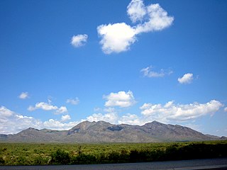
Mount Taylor is an inactive stratovolcano in northwest New Mexico, northeast of the town of Grants. It is the high point of the San Mateo Mountains and the highest point in the Cibola National Forest. It was named in 1849 for then president Zachary Taylor. Prior to that, it was called Cebolleta by the Spanish; the name persists as one name for the northern portion of the San Mateo Mountains, a large mesa. Mount Taylor is largely forested, rising like a blue cone above the desert below. Its slopes were an important source of lumber for neighboring pueblos.

The Zuni (Zuñi) River is a tributary of the Little Colorado River in the southwestern United States. It has its origin in Cibola County, New Mexico, in the Zuñi Mountains at the Continental Divide. The river flows off the western slopes of the Zuñi Mountains in a generally southwesterly direction through the Zuni Indian Reservation to join the Little Colorado River in eastern Arizona. The Zuni River is approximately 90 miles (140 km) long, and has a drainage basin in New Mexico of approximately 1,300 square miles (3,400 km2).

Mount Sedgwick is a mountain located within the West Coast Range, in the West Coast region of Tasmania, Australia.

Baldy Mountain, Baldy Peak, Mount Baldy, or Old Baldy is the highest peak in the Cimarron Range, a subrange of the Sangre de Cristo Mountains of New Mexico. It is located in Colfax County, about 6 miles (10 km) northeast of Eagle Nest. It rises abruptly, with 3,640 feet (1,110 m) of vertical relief, from the Moreno Valley to the west and has a total elevation of 12,441 feet (3,792 m).

Big Hatchet Peak is the high point of the Big Hatchet Mountains, a small but rugged range in the southwest corner of New Mexico, in the United States. The mountains are located in southeast Hidalgo County, about 50 miles (80 km) southwest of Deming. The range runs roughly northwest-southeast, and is about 12 miles (19 km) long; the southeastern edge of the range is within 3.5 miles (6 km) of the border with Mexico. They lie primarily on BLM land.

The Zuni Indian Reservation, also known as Pueblo of Zuni, is the homeland of the Zuni tribe of Native Americans.

Manzano Peak is the highest peak in the Manzano Mountains, a mountain range in the central part of the US State of New Mexico. It lies 7 miles (11 km) southwest of the town of Manzano and 18 miles (29 km) east-southeast of the town of Belen, in the Manzano Wilderness Area, part of the Mountainair Ranger District of the Cibola National Forest. It forms the striking southern anchor of the range, rising 3,900 feet (1,189 m) in 3 miles (5 km) above its western base. The summit is below the tree line, but has views to the east, south, and west.
Whitewater Baldy is the highest point of the Mogollon Mountains and the 3rd highest mountain in Southern New Mexico, after Sierra Blanca Peak and Lincoln County's Lookout Mountain. It is located in Catron County in the Gila Wilderness, part of the Gila National Forest. It lies about 15 miles (24 km) east of the town of Glenwood.
West Blue Mountain is the highest peak in the San Mateo Mountains of southwestern New Mexico, in the United States. It rises in the southern half of the range, far from any paved road, making access difficult and traffic on the surrounding trails very light. Its summit is the highest point in the Apache Kid Wilderness of the Cibola National Forest.
The San Mateo Mountains are a small mountain range in Cibola and McKinley counties of New Mexico, in the southwestern United States. The highest point in the range is Mount Taylor, at 11,301 ft. The range lies just northeast of the community of Grants, and about 60 miles (100 km) west of Albuquerque. This range should not be confused with the identically named range in Socorro County, south of this range.
Salinas Peak is the highest point in the San Andres Mountains of south-central New Mexico, in the United States. It lies near the northern end of the range, about 50 miles (80 km) northwest of Alamogordo and 50 miles (80 km) southeast of Socorro. To the east lies the Tularosa Basin, while to the west is the Jornada del Muerto.
Ladrón Peak is an isolated, highly visible peak in central New Mexico, lying about 50 mi (80 km) southwest of Albuquerque. Ladron Peak is the only major peak in the compact range known as the Sierra Ladrones, which lies between the Rio Puerco to the east and the Rio Salado to the southwest.


