
The South Platte River is one of the two principal tributaries of the Platte River. Flowing through the U.S. states of Colorado and Nebraska, it is itself a major river of the American Midwest and the American Southwest/Mountain West. Its drainage basin includes much of the eastern flank of the Rocky Mountains in Colorado, much of the populated region known as the Colorado Front Range and Eastern Plains, and a portion of southeastern Wyoming in the vicinity of the city of Cheyenne. It joins the North Platte River in western Nebraska to form the Platte, which then flows across Nebraska to the Missouri. The river serves as the principal source of water for eastern Colorado. In its valley along the foothills in Colorado, it has permitted agriculture in an area of the Colorado Piedmont and Great Plains that is otherwise arid.

Guadalupe Mountains National Park is a national park of the United States in the Guadalupe Mountains, east of El Paso, Texas. The mountain range includes Guadalupe Peak, the highest point in Texas at 8,751 feet (2,667 m), and El Capitan used as a landmark by travelers on the route later followed by the Butterfield Overland Mail stagecoach line. The ruins of a stagecoach station stand near the Pine Springs visitor center. The restored Frijole Ranch contains a small museum of local history and is the trailhead for Smith Spring. The park covers 86,367 acres in the same mountain range as Carlsbad Caverns National Park, about 25 miles (40 km) to the north in New Mexico. The Guadalupe Peak Trail winds through pinyon pine and Douglas-fir forests as it ascends over 3,000 feet (910 m) to the summit of Guadalupe Peak, with views of El Capitan and the Chihuahuan Desert.

The Guadalupe Mountains are a mountain range located in West Texas and southeastern New Mexico. The range includes the highest summit in Texas, Guadalupe Peak, 8,751 ft (2,667 m), and the "signature peak" of West Texas, El Capitan, both of which are located within Guadalupe Mountains National Park. The Guadalupe Mountains are bordered by the Pecos River valley and Llano Estacado to the east and north, Delaware Mountains to the south, and Sacramento Mountains to the west. One of the clearest exposures of a prehistoric reef is preserved in the mountain range's bedrock geology. Bedrock contains fossils of reef-dwelling organisms from the Permian period, and the geology is widely studied, mostly by stratigraphers, paleontologists, and Paleoecologists.

Mount Wrightson is a 9,456-foot (2,882 m) peak in the Santa Rita Mountains within the Coronado National Forest, in southern Arizona, United States.

The Sierra Blanca is an ultra-prominent range of volcanic mountains in Lincoln and Otero counties in the south-central part of the U.S. state of New Mexico. The range is about 40 miles (64 km) from north to south and 20 miles (32 km) wide.

Apache Pass, also known by its earlier Spanish name Puerto del Dado, is a historic mountain pass in the U.S. state of Arizona between the Dos Cabezas Mountains and Chiricahua Mountains at an elevation of 5,110 feet (1,560 m). It is approximately 20 miles (32 km) east-southeast of Willcox, Arizona, in Cochise County.

Franklin Mountains State Park is a state park in El Paso, Texas, United States. The park is named after the Franklin Mountains, a mountainous range that extends 23 mi (37 km) from El Paso to New Mexico. Its headquarters are located at an elevation of 5,426 feet (1,654 m) with the highest peak, North Franklin Mountain, reaching 7,192 feet (2,192 m). Covering 24,247.56 acres (9,813 ha), it is one of the largest urban parks in the U.S. lying completely within city limits. The park is open year-round for recreational activities such as hiking, mountain biking, picnicking, and scenic driving.
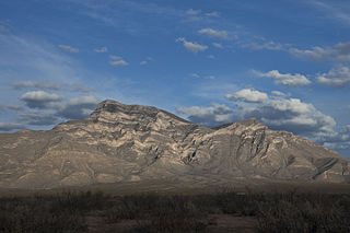
Big Hatchet Peak is the high point of the Big Hatchet Mountains, a small but rugged range in the southwest corner of New Mexico, in the United States. The mountains are located in southeast Hidalgo County, about 50 miles (80 km) southwest of Deming. The range runs roughly northwest-southeast, and is about 12 miles (19 km) long; the southeastern edge of the range is within 3.5 miles (6 km) of the border with Mexico. They lie primarily on BLM land.

Steins is a ghost town in Stein's Pass of Hidalgo County, New Mexico. It was originally called Stein's Pass after the nearby pass through the Peloncillo Mountains. The pass was named after United States Army Major Enoch Steen, who camped nearby in 1856, as he explored the recently acquired Gadsden Purchase.
McKnight Mountain is the highest peak in the Black Range of southwestern New Mexico, in the southwestern United States. It is located about 30 miles (48 km) northeast of Silver City, in the Aldo Leopold Wilderness of the Gila National Forest.

Salinas Peak is the highest point in the San Andres Mountains of south-central New Mexico, in the United States. It lies near the northern end of the range, about 50 miles (80 km) northwest of Alamogordo and 50 miles (80 km) southeast of Socorro. To the east lies the Tularosa Basin, while to the west is the Jornada del Muerto.

Arizona is a landlocked state situated in the southwestern region of the United States of America. It has a vast and diverse geography famous for its deep canyons, high- and low-elevation deserts, numerous natural rock formations, and volcanic mountain ranges. Arizona shares land borders with Utah to the north, the Mexican state of Sonora to the south, New Mexico to the east, and Nevada to the northwest, as well as water borders with California and the Mexican state of Baja California to the southwest along the Colorado River. Arizona is also one of the Four Corners states and is diagonally adjacent to Colorado.
Doubtful Canyon was the name of two canyons in the Peloncillo Mountains, once considered in the 19th century as one canyon that served as the pass through those mountains.
The Butterfield Overland Mail was a transport and mail delivery system that employed stagecoaches that travelled on a specific route between St. Louis, Missouri and San Francisco, California and which passed through the New Mexico Territory. It was created by the United States Congress on March 3, 1857, and operated until March 30, 1861. The route that was operated extended from where the ferry across the Colorado River to Fort Yuma Station, California was located, through New Mexico Territory via Tucson to the Rio Grande and Mesilla, New Mexico then south to Franklin, Texas, midpoint on the route. The New Mexico Territory mail route was divided into two divisions each under a superintendent. Tucson was the headquarters of the 3rd Division of the Butterfield Overland Mail Company. Franklin Station in the town of Franklin,, was the headquarters of the 4th Division.

Enoch Steen was a United States military officer and western explorer. He joined the United States Army in 1832, serving at posts throughout the United States, including many remote locations in the west. During his military service, Steen explored parts of the western United States including large areas of southern New Mexico and southeastern Oregon. He served as the commander of several Union Army forts during the American Civil War. Today, there are landmarks in Oklahoma, Oregon, and New Mexico named in his honor; however, many of the place names are misspelled as Stein.
West Doubtful Canyon was the name of one of two canyons in the Peloncillo Mountains, once considered in the 19th century as one canyon "Doubtful Canyon" that served as the pass through those mountains. Today the canyon bearing the name Doubtful Canyon, is mostly in Cochise County, Arizona, United States, near the New Mexico border. It descends to the east into the Animas Valley past Steins Peak it is in Hidalgo County, New Mexico. The western canyon is now called West Doubtful Canyon and it descends into the San Simon Valley, in Cochise County, Arizona.
Stein's Peak Station, was one of the original stage stations of the Butterfield Overland Mail. Its ruins are still to be seen in Doubtful Canyon, at an elevation of 4652 feet, northeast of Stein's Peak in Hidalgo County, New Mexico. Stein's Peak Station, was 35 miles (56 km) east of Apache Pass Station and 42 miles (68 km) west of Soldier's Farewell Stage Station. Later stations were located midway between these stations to provide water and changes of horse teams in the hot, arid climate. These were San Simon Station to the west and Mexican Springs Station to the east of Lordsburg, New Mexico.

San Simon River is an ephemeral river, or stream running through the San Simon Valley in Graham and Cochise County, Arizona and Hidalgo County, New Mexico. Its mouth is at its confluence with the Gila River at Safford in Graham County. Its source is located at 31°51′21″N109°01′27″W.
Stein's Pass, is a gap or mountain pass through the Peloncillo Mountains of Hidalgo County, New Mexico. The pass was named after United States Army Major Enoch Steen, who camped nearby in 1856, as he explored the recently acquired Gadsden Purchase. The pass is in the form of a canyon cut through the mountains through which Steins Creek flows to the west just west of the apex of the pass to the canyon mouth at 32°13′19″N109°01′48″W.
Massacre Peak, a summit at an elevation of 5,667 feet (1,727 m) in the Cookes Range in Luna County, New Mexico.
