History
Placer mining for gold in the Ortiz Mountains was carried out by the early Spanish using Indian slave labor, but the first significant placer workings began in 1821. The underground Ortiz Mine was opened in 1822. By 1832, several gold-bearing veins had been discovered. The first gold lode mine in the West was in the Ortiz, as well as the first railroad in New Mexico. The gold separation mill was the work of Thomas Edison. But following World War I, mining costs had risen and the low grade ores and relative lack of water resulted in the last mines being closed.
In 1973, Consolidated Gold Fields opened an open pit on the Cunningham Hill deposit, the same deposit that the Ortiz Mine had worked. Using the heap and leach method, they extracted approximately 250,000 ounces of gold before closing in 1986. A joint venture of LAC Minerals and Pegasus Gold Corporation [10] did exploratory work beginning in 1989 primarily investigating the Carache Canyon and Lucas Canyon deposits. They did open a new adit into the Carache Canyon deposit, but stopped after 1719 feet due to regulatory issues, lawsuits and a declining gold price.
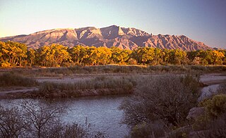
The Sandia Mountains are a mountain range located in Bernalillo and Sandoval counties, immediately to the east of the city of Albuquerque in New Mexico in the southwestern United States. The mountains are just due south of the southern terminus of the Rocky Mountains, and are part of the Sandia–Manzano Mountains. This is largely within the Cibola National Forest and protected as the Sandia Mountain Wilderness. The highest point is Sandia Crest, 10,678 feet (3,255 m).

The Sevier River is a 400-mile (640 km)-long river in the Great Basin of southwestern Utah in the United States. Originating west of Bryce Canyon National Park, the river flows north through a chain of high farming valleys and steep canyons along the west side of the Sevier Plateau before turning southwest and terminating in the endorheic basin of Sevier Lake in the Sevier Desert. It is used extensively for irrigation along its course, with the consequence that Sevier Lake is usually dry.

The Pah Rah Range is a mountain range located in western Nevada in Washoe County just to the northeast of Reno. It is a hook shaped range with the main eastern portion oriented northwest–southeast, approximately 20 miles (32 km) long. The northwest flowing Cottonwood Creek in Warm Springs Valley is bounded on three sides by the range. To the south and east the Truckee River forms the boundary and Pyramid Lake is at the northeast. Spanish Springs Valley north of Reno forms the southwest margin. To the north, the narrow Mullen Pass separates the Pah Rah Range from the Virginia Mountains.
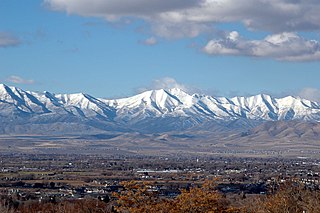
The Oquirrh Mountains is a mountain range that runs north–south for approximately 30 miles (50 km) to form the west side of Utah's Salt Lake Valley, separating it from Tooele Valley. The range runs from northwestern Utah County–central & eastern Tooele County, to the south shore of the Great Salt Lake. The highest elevation is Flat Top Mountain at 10,620 ft. The name Oquirrh was taken from the Goshute word meaning "wood sitting."

Porphyry copper deposits are copper ore bodies that are formed from hydrothermal fluids that originate from a voluminous magma chamber several kilometers below the deposit itself. Predating or associated with those fluids are vertical dikes of porphyritic intrusive rocks from which this deposit type derives its name. In later stages, circulating meteoric fluids may interact with the magmatic fluids. Successive envelopes of hydrothermal alteration typically enclose a core of disseminated ore minerals in often stockwork-forming hairline fractures and veins. Because of their large volume, porphyry orebodies can be economic from copper concentrations as low as 0.15% copper and can have economic amounts of by-products such as molybdenum, silver, and gold. In some mines, those metals are the main product.

A polymetallic replacement deposit, also known as carbonate replacement deposit or high-temperature carbonate-hosted Ag-Pb-Zn deposit, is an orebody of metallic minerals formed by the replacement of sedimentary, usually carbonate rock, by metal-bearing solutions in the vicinity of igneous intrusions. When the ore forms a blanketlike body along the bedding plane of the rock, it is commonly called a manto ore deposit. Other ore geometries are chimneys and veins. Polymetallic replacements/mantos are often stratiform wall-rock replacement orebodies distal to porphyry copper deposits, or porphyry molybdenum deposits. The term manto is derived from the Spanish word manto, meaning "mantle" or "cloak".

In the United States, gold mining has taken place continually since the discovery of gold at the Reed farm in North Carolina in 1799. The first documented occurrence of gold was in Virginia in 1782. Some minor gold production took place in North Carolina as early as 1793, but created no excitement. The discovery on the Reed farm in 1799 which was identified as gold in 1802 and subsequently mined marked the first commercial production.

The Caballo Mountains, are a mountain range located in Sierra and Doña Ana Counties, New Mexico, United States. The range is located east of the Rio Grande and Caballo Lake, and west of the Jornada del Muerto; the south of the range extends into northwest Doña Ana County. The nearest towns are Truth or Consequences and Hatch.
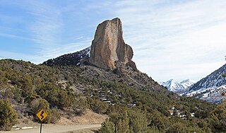
Needle Rock Natural Area is located at the western edge of the West Elk Mountains of Colorado. The surrounding terrain is characterized by laccolithic mountains flanked by precipitous cliffs, extensive talus aprons, forested mesas, canyons, and spacious, well-watered intermontane basins. Needle Rock is an intrusive plug of monzonite porphyry cropping out 3.5 miles (5.6 km) east-northeast of the Town of Crawford in Delta County, Colorado, United States. With an elevation of 7,797 feet (2,377 m), the towering rock spire stands 800 feet (240 m) tall above the floor of the Smith Fork of the Gunnison River valley. The massive rock feature originated in the Oligocene geological epoch when magma intruded between existing sedimentary rocks as the crown of a buried laccolith or possibly the underlying conduit of a laccolith. Subsequent erosion has exposed the prominent rock formation seen in the natural area today.

The Temescal Mountains, also known as the Sierra Temescal, are one of the northernmost mountain ranges of the Peninsular Ranges in western Riverside County, in Southern California in the United States. They extend for approximately 25 mi (40 km) southeast of the Santa Ana River east of the Elsinore Fault Zone to the Temecula Basin and form the western edge of the Perris Block.

The geology of Namibia encompasses rocks of Paleoproterozoic, Mesoproterozoic and Neoproterozoic and Paleozoic to Cenozoic age. About 46% of the countryʼs surface are bedrock exposure, while the remainder is covered by the young overburden sediments of the Kalahari and Namib deserts.

The geology of Arizona began to form in the Precambrian. Igneous and metamorphic crystalline basement rock may have been much older, but was overwritten during the Yavapai and Mazatzal orogenies in the Proterozoic. The Grenville orogeny to the east caused Arizona to fill with sediments, shedding into a shallow sea. Limestone formed in the sea was metamorphosed by mafic intrusions. The Great Unconformity is a famous gap in the stratigraphic record, as Arizona experienced 900 million years of terrestrial conditions, except in isolated basins. The region oscillated between terrestrial and shallow ocean conditions during the Paleozoic as multi-cellular life became common and three major orogenies to the east shed sediments before North America became part of the supercontinent Pangaea. The breakup of Pangaea was accompanied by the subduction of the Farallon Plate, which drove volcanism during the Nevadan orogeny and the Sevier orogeny in the Mesozoic, which covered much of Arizona in volcanic debris and sediments. The Mid-Tertiary ignimbrite flare-up created smaller mountain ranges with extensive ash and lava in the Cenozoic, followed by the sinking of the Farallon slab in the mantle throughout the past 14 million years, which has created the Basin and Range Province. Arizona has extensive mineralization in veins, due to hydrothermal fluids and is notable for copper-gold porphyry, lead, zinc, rare minerals formed from copper enrichment and evaporites among other resources.

The geology of New Mexico includes bedrock exposures of four physiographic provinces, with ages ranging from almost 1800 million years (Ma) to nearly the present day. Here the Great Plains, southern Rocky Mountains, Colorado Plateau, and Basin and Range Provinces meet, giving the state great geologic diversity.

The Espinaso Formation is a geologic formation in New Mexico. It has a radiometric age of 34.6 to 26.9 million years, corresponding to the late Eocene through Oligocene epochs.

The Santa Fe Group is a group of geologic formations in New Mexico and Colorado. It contains fossils characteristic of the Oligocene through Pleistocene epochs. The group consists of basin-filling sedimentary and volcanic rocks of the Rio Grande rift, and contains important regional aquifers.

The geology of California is highly complex, with numerous mountain ranges, substantial faulting and tectonic activity, rich natural resources and a history of both ancient and comparatively recent intense geological activity. The area formed as a series of small island arcs, deep-ocean sediments and mafic oceanic crust accreted to the western edge of North America, producing a series of deep basins and high mountain ranges.

The Ortiz porphyry belt is a cluster of small mountain ranges in Santa Fe County, New Mexico. The mountains are laccoliths formed by intrusion of magma into the upper layers of the Earth's crust. This took place during the late Eocene through early Oligocene, from 36.2 to 31.4 million years ago (Ma.

The Tuerto Formation is a geologic formation exposed around the Ortiz Mountains of New Mexico. It is estimated to be of Pliocene to Pleistocene age, and forms the gravel cap of the Ortiz surface, one of the first pediment surfaces recognized by geologists.
The Blackshare Formation is a geologic formation exposed in the Hagan Basin west of the Ortiz Mountains of New Mexico. It is estimated be to of Miocene age.
