Eastern New Mexico

Last updated
Eastern New Mexico
Region
Curry County Eastern New Mexico 2010.jpg
Windmill north of Bellview, New Mexico
LlanoEstacadoShadedRelief.jpg
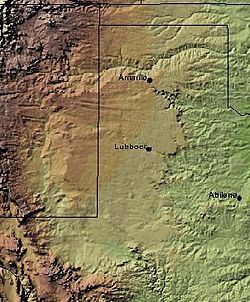
Shaded relief image of the Llano Estacado including the portion in Eastern New Mexico
CountryFlag of the United States.svg  United States
StateFlag of New Mexico.svg  New Mexico
Region Llano Estacado
Website Llano Estacado

Eastern New Mexico is a physiographic subregion within the U.S. state of New Mexico. The region is sometimes called the "High Plains," or "Eastern Plains (of New Mexico)," and was historically referred to as part of the "Great American Desert". The region is largely coterminous with the portion of the Llano Estacado in New Mexico. Portions of Eastern New Mexico's elevation extend to over 4,000 ft (1,200 m). The region is characterized by flat, largely featureless terrain with the exception of the Pecos River valley and the abrupt breaks along the Mescalero Ridge and northern caprock escarpments of the Llano Estacado. The region typically lacks the high relief of central and northern New Mexico, such as that in the Sangre de Cristo and Sandia mountain ranges. The climate is semi-arid with hot summers and is characterized by significant wind and dust storms in the springtime.

Contents

Like much of the Llano Estacado region, Eastern New Mexico is largely rural and agricultural, and resembles West Texas in geography, economy, and demographics. The population is sparse as compared to the rest of the country. The region includes portions of the counties of Curry, De Baca, Guadalupe, Lea, Quay, and Roosevelt. It is served by Eastern New Mexico University, a state university located in Portales, and the Blackwater Draw archaeological site is located there.

Cities in Eastern New Mexico

The largest cities in Eastern New Mexico are:

CityPopulation (2020)
Roswell 48,422
Hobbs 40,508
Clovis 38,567
Carlsbad 32,238
Portales 12,137
Tucumcari 5,278

See also


Related Research Articles

<span class="mw-page-title-main">Pecos River</span> River in New Mexico and Texas, United States

The Pecos River originates in north-central New Mexico and flows into Texas, emptying into the Rio Grande. Its headwaters are on the eastern slope of the Sangre de Cristo mountain range in Mora County north of Pecos, New Mexico, at an elevation of over 12,000 feet (3,700 m). The river flows for 926 miles (1,490 km) before reaching the Rio Grande near Del Rio. Its drainage basin encompasses about 44,300 square miles (115,000 km2).

<span class="mw-page-title-main">Texas Panhandle</span> Region in Texas, United States

The Texas Panhandle is a region of the U.S. state of Texas consisting of the northernmost 26 counties in the state. The panhandle is a square-shaped area bordered by New Mexico to the west and Oklahoma to the north and east. It is adjacent to the Oklahoma Panhandle, land which Texas previously claimed. The 1820 Missouri Compromise declared no slavery would be allowed in states admitted from the Louisiana Purchase above 36°30′ north latitude. Texas was annexed in 1845 from still more westerly land. The Compromise of 1850 removed territory north of this line from Texas, and set the border between the Texas Pandhandle and the New Mexico Territory at the 103rd meridian west. The eastern border at the 100th meridian west was inherited from the Adams–Onís Treaty of 1819, which defined the border between the United States and New Spain. The Handbook of Texas defines the southern border of Swisher County as the southern boundary of the Texas Panhandle region.

<span class="mw-page-title-main">Llano Estacado</span> Southwestern United States in New Mexico and Texas

The Llano Estacado, sometimes translated into English as the Staked Plains, is a region in the Southwestern United States that encompasses parts of eastern New Mexico and northwestern Texas. One of the largest mesas or tablelands on the North American continent, the elevation rises from 3,000 feet (900 m) in the southeast to over 5,000 feet (1,500 m) in the northwest, sloping almost uniformly at about 10 feet per mile (2 m/km).

<span class="mw-page-title-main">West Texas</span> Region in Texas, United States

West Texas is a loosely defined region in the U.S. state of Texas, generally encompassing the arid and semiarid lands west of a line drawn between the cities of Wichita Falls, Abilene, and Del Rio.

<span class="mw-page-title-main">South Plains</span> Region in Texas, United States

The South Plains is a region in northwest Texas, consisting of 24 counties. The main crop is cotton.

<span class="mw-page-title-main">Mescalero</span> Native American tribe in New Mexico

Mescalero or Mescalero Apache is an Apache tribe of Southern Athabaskan–speaking Native Americans. The tribe is federally recognized as the Mescalero Apache Tribe of the Mescalero Apache Reservation, located in south-central New Mexico.

<span class="mw-page-title-main">Mescalero Ridge</span> Geographical transition in New Mexico and Texas, the Llano Estacados western border

The Mescalero Ridge forms the western edge of the great Llano Estacado, a vast plateau or tableland in the southwestern United States in New Mexico and Texas. It is the western equivalent of the Caprock Escarpment, which defines the eastern edge of the Llano Estacado.

<span class="mw-page-title-main">High Plains (United States)</span> Subregion of the Great Plains, mainly in the Western United States

The High Plains are a subregion of the Great Plains, mainly in the Western United States, but also partly in the Midwest states of Nebraska, Kansas, and South Dakota, generally encompassing the western part of the Great Plains before the region reaches the Rocky Mountains. The High Plains are located in eastern Montana, southeastern Wyoming, southwestern South Dakota, western Nebraska, eastern Colorado, western Kansas, eastern New Mexico, the Oklahoma Panhandle, and the Texas Panhandle. The southern region of the Western High Plains ecology region contains the geological formation known as Llano Estacado which can be seen from a short distance or on satellite maps. From east to west, the High Plains rise in elevation from around 1,800 to 7,000 ft.

<span class="mw-page-title-main">Caprock Escarpment</span> Geographical transition in Texas and New Mexico

The Caprock Escarpment is a term used in West Texas and Eastern New Mexico to describe the geographical transition point between the level High Plains of the Llano Estacado and the surrounding rolling terrain. In Texas, the escarpment stretches around 200 mi (320 km) south-southwest from the northeast corner of the Texas Panhandle near the Oklahoma border. The escarpment is especially notable, from north to south, in Briscoe, Floyd, Motley, Crosby, Dickens, Garza, and Borden Counties. In New Mexico, a prominent escarpment exists along the northernmost extension of the Llano Estacado, especially to the south of San Jon and Tucumcari, both in Quay County, New Mexico. Along the western edge of the Llano Estacado, the portion of the escarpment that stretches from Caprock to Maljamar, New Mexico, is called the Mescalero Ridge.

<span class="mw-page-title-main">Geography of Texas</span> Geographical features of Texas

The geography of Texas is diverse and large. Occupying about 7% of the total water and land area of the U.S., it is the second largest state after Alaska, and is the southernmost part of the Great Plains, which end in the south against the folded Sierra Madre Oriental of Mexico. Texas is in the South Central United States of America, and is considered to form part of the U.S. South and also part of the U.S. Southwest.

<span class="mw-page-title-main">Tucumcari Mountain</span>

Tucumcari Mountain, once referred to as Tucumcari Peak or Mesa Tucumcari, is a mesa situated just outside Tucumcari, New Mexico.

<span class="mw-page-title-main">Southland, Texas</span> Unincorporated community in Texas, United States

Southland is an unincorporated community in Garza County, Texas, United States. It lies along the eastern edge of the Llano Estacado on U.S. Route 84, twenty miles northwest of Post.

<span class="mw-page-title-main">Blanco Canyon</span>

Blanco Canyon is a canyon located in the U.S. state of Texas. Eroded by the White River into the Caprock Escarpment on the east side of the Llano Estacado, the canyon runs for 34 miles (55 km) in a southeasterly direction, gradually widening from its beginning in southwestern Floyd County to 10 miles (16 km) across at its mouth in southeastern Crosby County. It also gradually deepens from 50 feet (15 m) at its beginning to 300 to 500 feet at its mouth. One side canyon, 5-mile long Crawfish Canyon, was cut by Crawfish Creek as it feeds into the White River from the west.

<span class="mw-page-title-main">Monahans Sandhills State Park</span> State park in Texas, United States

The Monahans Sandhills State Park is a 3,840-acre (1,550 ha) state park located in the southern Llano Estacado in Ward County and Winkler County, Texas. The closest major town is Monahans, Texas, and the closest limited-access highway ingress is Exit 86 on Interstate 20.

The Comanche Trail, sometimes called the Comanche War Trail or the Comanche Trace, was a travel route in Texas established by the nomadic Comanche nation.

<span class="mw-page-title-main">Salt Fork Brazos River</span> River

The Salt Fork Brazos River is a braided, highly intermittent stream about 150 mi (240 km) long, heading along the edge of the Llano Estacado about 26 mi (42 km) east-southeast of Lubbock, Texas. From its source, it flows generally east-southeastward to join the Double Mountain Fork to form the Brazos River about 18 mi (29 km) west-northwest of Haskell, Texas. The Salt Fork stretches across portions of Crosby, Garza, Kent, and Stonewall counties of West Texas.

<span class="mw-page-title-main">Mushaway Peak</span>

Mushaway Peak is a small but conspicuous butte located 4 mi (6.4 km) southeast of Gail in central Borden County, Texas. It is one of the region's most venerable landmarks.

<span class="mw-page-title-main">Little Red River (Texas)</span> River

The Little Red River is an intermittent stream about 30 mi (48 km) long, formed at the confluence of the North Prong and South Prong Little Red River in Briscoe County, Texas, and flowing east-northeastward to join the Prairie Dog Town Fork Red River in Hall County, Texas.

<span class="mw-page-title-main">McDonald Creek (Salt Fork Brazos River tributary)</span> River in the United States

McDonald Creek is an intermittent stream, about 25 mi (40 km) long, heading about 10 mi (16 km) south-southwest of Crosbyton, Texas, and trending generally southeast to join the Salt Fork Brazos River near the community of Verbena, Texas.

<span class="mw-page-title-main">Whiteflat, Texas</span> Ghost Town in Texas, United States

Whiteflat is a ghost town in Motley County, Texas, United States. The population was estimated to be 3 at the 2000 census.