The primary non-government industries of Farmington are the production of petroleum, natural gas, and coal and its function as a major retail hub. Outside of Farmington, the Navajo Mine (coal), operated by the Navajo Transitional Energy Company (NTEC), is used entirely for fuel for the nearby Four Corners Generating Station to produce electric power.
History
The area that is now Farmington was settled by Ancestral Pueblo people in the 7th Century. Ruins can be visited at nearby Salmon Ruins and at the Aztec Ruins.[8] When the Ancestral Puebloans left the area, the Navajos, Jicarilla Apaches, and Utes moved into the area. A key part of the region was known in Navajo as Tóta' which means "where three rivers meet".[9]
Although Spanish and American mineral prospecting happened in the area, there were few permanent settlements. In 1868, the Navajo Nation was created, taking up the western half of San Juan County. Six years later, the U.S. government offered territory in the rest of San Juan County to the Jicarilla Apache but they refused. As a result, the area was opened for settlement and a number of settlers moved into the region from Southern Colorado.[8] The area was originally known as "Junction City" because of the access to the three rivers.[9]
In 1901 the town was incorporated and named Farmington with a population of 548.[8] By September 19, 1905, the railroad was finished connecting Farmington to Durango, Colorado, expanding economic and settlement opportunities. It was unusual in that it was a standard-gauge railway that connected to the Denver & Rio Grande Western Railroadnarrow-gauge lines of southwestern Colorado. The railroad converted the line to narrow gauge in 1923. The line was abandoned in 1968 and dismantled to Durango in 1969.[10] In addition, in the 1920s there was significant investment in natural gas and oil in the area, although actual production remained low until the 1950s.
On March 18, 1950, Farmington was the site of a mass UFO sighting in which over half the town's population was reported to have seen large saucers in the sky flying at rapid speeds.[9] The population was expanding rapidly after the 1940s construction of a developed road connecting Farmington to U.S. Route 66 and Albuquerque and the San Juan Basin Natural Gas Pipeline in 1953, led by Tom Bolack.[8] However, the significant connection to the energy industry made the economics of the town largely vulnerable to international market fluctuations during the 1970s energy crisis and resulted in some economic diversification.[8]
In 1967, as part of a joint U.S. Government-El Paso Electric operation, an underground nuclear detonation occurred 50 miles (80km) east of Farmington and about 25 miles (40km) south of Dulce, New Mexico in present-day Carson National Forest. This pilot project of Operation Plowshare, code-named Project Gasbuggy, was an attempt to fracture a large volume of underground bedrock to make more natural gas available for extraction by gas wells.[11]
The people of Farmington have been the subject of several civil rights investigations, including the 2005 report, The Farmington Report: Civil Rights for Native Americans 30 Years Later.[12]
Geography
According to the U.S. Census Bureau, Farmington has a total area of 32.0 square miles (83km2), of which 31.5 square miles (82km2) is land and 0.5 square miles (1.3km2) is water.
Climate
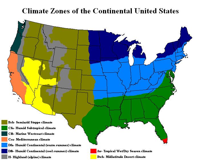
Farmington has a semi-arid climate.[13] Despite its altitude of 5,473 feet (1,668m), the city can experience hot summers and cold winters with low precipitation throughout the year. The average annual snowfall is 12.3 inches (31cm).[14]
Climate data for Farmington, New Mexico, 1991–2020 normals, extremes 1978–present
As of the census[18] of 2010, there were 45,895 people and 17,548 housing units in Farmington. The racial makeup of the city was 62.8% White (including 52.4% White non-Hispanic), 1.0% African American, 22.2% Native American, 0.6% Asian, 0.1% Pacific Islander, and 4.2% from two or more races. Hispanic or Latino of any race were 22.4% of the population.
There were 16,466 households, out of which 33.4% had children under the age of 18 living with them, 49% were married couples living together, 13.6% had a female householder with no husband present, and 30.1% were non-families. 21.7% of all households were made up of individuals, and 8% had someone living alone who was 65 years of age or older. The average household size was 2.7 and the average family size was 3.19.
A.F. Miller store and home, c.1885, the first store in Farmington
Arts and culture
Farmington has been the home of the Connie Mack World Series baseball tournament, played in August every year at Ricketts Park (capacity 5,072), since 1965 (except in 2020, when it was cancelled due to the COVID-19 pandemic). Connie Mack league regular season play includes players age 16 to 18. The Connie Mack World Series consists of 10 or more teams from various regions around the United States, including Puerto Rico.[19][20]
Farmington holds a riverfest once a year. Area rivers are celebrated with a festival of music, fine arts, food, entertainment, a 10K and 5K run and walk, riverside trail walks, and river raft rides.
Piñon Hills Golf Course, designed by Ken Dye, in Farmington is one of the United States' Top Municipal Golf Courses. Owned and operated by the City of Farmington, Pinon Hills has been ranked in the Top Municipal Golf Courses by Golfweek Magazine for several years.[21]
Fishing, fly and reel, is a very popular activity in Farmington. Fishing is permitted on the San Juan River, Navajo Lake, Lake Farmington, Morgan Lake, the Animas River, Jackson Lake and Cutter Dam.
San Juan College is a public two-year college with - as of Fall 2021 - a per-semester headcount of almost 6,000 persons, and a full time equivalent (FTE) enrollment of just over 3,000.[28][29]
Farmington Public Library moved into a new building in 2003 and holds about 200,000 items in its collection. There was a branch library in Shiprock that is currently closed.
U.S. Highway 550 does not run through Farmington (nearby in Bloomfield and Aztec), but is a commonly referenced arterial by Farmington as a means to connect with central New Mexico, Interstate 25, Albuquerque, and (via I-25) the capital city of Santa Fe.
Intercity bus
There is intercity bus service in Farmington, The Red Apple Transit.
The Farmington Electric Utility System (FEUS) is owned and operated by the City of Farmington, serving approximately 46,000 metered customers. Its service territory covers 1,718 square miles and encompasses the city, much of San Juan County, and a small portion of Rio Arriba County.
As of June 2021, the City generates approximately 36% of its consumed power from its own gas-fired generation facilities, 17% from the Navajo Dam hydroelectric facility, and the remainder purchased from third party generation resources.
Aside from Navajo Lake (where generation facilities were established in 1988), a nominal amount of expansion of its owned generation facilities has been using renewable resources. Renewable energy is predominantly sourced from external third parties or via purchasing agreements with net metered facilities in its service area.[31]
Water and wastewater
The city's water comes from Farmington Lake, which is sourced from and fed using pumps located on the Animas River. Water and wastewater treatment facilities, operations, and management are all contracted by the city to Jacobs Engineering Solutions.[32]
Solid waste
The City contracts all solid waste operations to Waste Management (of New Mexico) Inc., including general solid waste, recycling facilities and operations, and hazardous waste disposal. Disposal of City waste is done at the San Juan County Landfill, owned by the county and also operated by Waste Management of New Mexico.[33][34]
Telecommunications
Cable service (television and Internet) is provided by Xfinity.
Mobile service (telephone and Internet) is provided by all major carriers. As of October 2023, 5G cellular service is made available via T-mobile and other major cellular providers.
Politics
As of August 2022, Farmington had approximately 28,548 active registered voters. There were 24.4% unaffiliated with a party, 51.0% Republican, 22.2% Democratic, 1.2% Libertarian, and 1.2% various other parties. Like the rest of San Juan County, it is a politically conservative community surrounded by generally more liberal counties, and situated within an overall more liberal/left-leaning state.[35][36]
Voting has historically strongly favored conservative ideals and candidates, although state and local government bonds and other tax-imposing initiatives are almost always approved by the electorate.[37]
Notable people
Tom Bolack (1918–1998) — Governor and Lieutenant Governor of New Mexico; Mayor of Farmington; oilman; rancher
↑Bureau of Indian Affairs, Division of Education, United States Department of the Interior (1958). "Navajo-English Dictionary". digscholarship.unco.edu. p.60.{{cite web}}: CS1 maint: multiple names: authors list (link)
This page is based on this Wikipedia article Text is available under the CC BY-SA 4.0 license; additional terms may apply. Images, videos and audio are available under their respective licenses.


