History
The area now known as Fruitland was traditional Navajo territory. This place is called Bááh Díílid in Navajo.
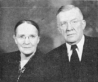
Euro-American settlers were allowed in 1877, and members of the Church of Jesus Christ of Latter-day Saints first settled in the area in 1878 and an organized group of settlers was sent there by the church in 1881 with Luther C. Burnham being prominent among them. Burnham was made bishop of the LDS ward there in 1883, which was named the Burnham Ward. From this time until the 1930s most of the residents called the area Burnham instead of Fruitland. [4]
For a time Brigham Young, Jr. maintained one of his residences at Fruitland. [5]
In 1930 the Burnham Ward had 718 members, including unbaptized children under age eight. [6]
The Young Stake was organized with headquarters at Burnham in 1912. By the 1970s the stake headquarters was Farmington. [7] In 1982 a Kirtland Stake was formed, which today covers from Kirtland west to Shiprock, New Mexico, and beyond. [8]
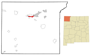
San Juan County is a county located in the U.S. state of New Mexico. As of the 2020 census, the population was 121,661 making it the fifth-most populous county in New Mexico. Its county seat is Aztec. The county was created in 1887.

Pima is a town in Graham County, Arizona, United States. As of the 2010 census, the population of the town was 2,387, up from 1,989 in 2000. The estimated population in 2018 was 2,512. Pima is part of the Safford Micropolitan Statistical Area.

Farmington is a city in San Juan County in the U.S. state of New Mexico. As of the 2020 census, the city had a population of 46,624 people. Farmington makes up one of the four metropolitan statistical areas (MSAs) in New Mexico.

Kirtland is a town, made up of part of the former census-designated place (CDP) of the same name in San Juan County, New Mexico, United States. The population of the former CDP was 6,190 at the 2000 census. It is part of the Farmington Metropolitan Statistical Area.

Nenahnezad is a census-designated place (CDP) in San Juan County, New Mexico, United States. The population was 726 at the 2000 census. Nenahnezad is a chapter community just to the south of Fruitland, between the towns of Farmington and Shiprock. It is part of the Farmington Metropolitan Statistical Area.

Shiprock is an unincorporated community on the Navajo reservation in San Juan County, New Mexico, United States. The population was 7,718 people in the 2020 census. For statistical purposes, the United States Census Bureau has defined Shiprock as a census-designated place (CDP). It is part of the Farmington Metropolitan Statistical Area.
Upper Fruitland is a census-designated place (CDP) in San Juan County, New Mexico, United States. The population was 1,664 at the 2000 census. It is part of the Farmington Metropolitan Statistical Area.

Monticello is a city located in San Juan County, Utah, United States and is the county seat. It is the second most populous city in San Juan County, with a population of 1,972 at the 2010 census. The Monticello area was settled in July 1887 by pioneers from the Church of Jesus Christ of Latter-day Saints. Monticello, named in honor of Thomas Jefferson's estate, became the county seat in 1895 and was incorporated as a city in 1910.

Brigham Young Jr. served as president of the Quorum of the Twelve Apostles of the Church of Jesus Christ of Latter-day Saints from 1899 until his death. His tenure was interrupted for one week in 1901 when Joseph F. Smith was the president of the Quorum.
Rezball, short for "reservation ball," is a style of basketball associated with Native Americans, particularly at the high school level in the Southwestern United States, where many of the Indian reservations were created in the country.

Andrew Jenson, born Anders Jensen, was a Danish immigrant to the United States who acted as an Assistant Church Historian of the Church of Jesus Christ of Latter-day Saints for much of the early-20th century. Jenson also served the church as president of the Scandinavian Mission.

John Pack was a member of the Council of Fifty and a missionary in the early days of the Church of Jesus Christ of Latter-day Saints.

The Bisti/De-Na-Zin Wilderness is a 45,000-acre (18,000 ha) wilderness area located in San Juan County in the U.S. state of New Mexico. Established in 1984, the Wilderness is a desolate area of steeply eroded badlands managed by the Bureau of Land Management, except three parcels of private Navajo land within its boundaries. The John D. Dingell, Jr. Conservation, Management, and Recreation Act, signed March 12, 2019, expanded the Bisti/De-Na-Zin Wilderness by approximately 2,250 acres.
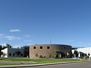
Central Consolidated Schools is a public school district based in Shiprock, New Mexico, United States.

The Church of Jesus Christ of Latter-day Saints in New Mexico refers to the Church of Jesus Christ of Latter-day Saints and its members in New Mexico. The first congregation of the Church in New Mexico was organized in 1895. It has since grown to 69,055 members in 137 congregations.
Oscar Walter McConkie was a Utah State Senator and leader in the Church of Jesus Christ of Latter-day Saints. He was the father of Bruce R. McConkie, a member of the Quorum of the Twelve Apostles of the LDS Church. A second son, Oscar W. McConkie, Jr., was a member of the Utah State Senate.

Woodruff is an unincorporated community in Navajo County, Arizona, United States. Woodruff is 10.5 miles (16.9 km) southeast of Holbrook. Woodruff has a post office with ZIP code 85942.

Ammon Meshach Tenney was an American Mormon missionary in Arizona, New Mexico and Mexico, who taught the message of the Church of Jesus Christ of Latter-day Saints to peoples of the Zuni and the Isleta Pueblos, baptizing hundreds. He also was the first president of the Mexican Mission after it was reorganized in 1901.

Waterflow is an unincorporated community and census-designated place in San Juan County, New Mexico, United States on the north side of the San Juan River. It is immediately west of Fruitland and north across the river from the Navajo Nation. It is east of Shiprock.

Silas Sanford Smith was a Mormon pioneer, a politician in the Utah Territory, and the leader of the San Juan Expedition that settled San Juan County, Utah.


