Glen Haven, Colorado

Last updated
Glen Haven, Colorado
GlenHavenStore.JPG
General store on the main street of Glen Haven, Colorado.
USA Colorado location map.svg
Red pog.svg
Glen Haven
Usa edcp location map.svg
Red pog.svg
Glen Haven
Coordinates: 40°27′13″N105°26′56″W / 40.45361°N 105.44889°W / 40.45361; -105.44889 Coordinates: 40°27′13″N105°26′56″W / 40.45361°N 105.44889°W / 40.45361; -105.44889
Country Flag of the United States.svg  United States
State Flag of Colorado.svg  Colorado
Counties Larimer [1]
Elevation
[1]
7,200 ft (2,200 m)
Time zone UTC-7 (MST)
  Summer (DST) UTC-6 (MDT)
ZIP code [2]
80532
Area code(s) 970

Glen Haven is an unincorporated community and a U.S. Post Office in Larimer County, Colorado, United States. The Glen Haven Post Office has the ZIP Code 80532. [2]

Contents

Geography

Glen Haven is located at 40°27′13″N105°26′56″W / 40.45361°N 105.44889°W / 40.45361; -105.44889 (40.453740,-105.448837). Situated in Roosevelt National Forest east of Rocky Mountain National Park, Fox Creek and West Creek join the North Fork Big Thompson River near downtown Glen Haven, which then flows through Devil's Gulch, receiving Miller Fork, and joins the Big Thompson River at Drake. Larimer County Road 43, the only road access to Glen Haven, takes a northeasterly route out of Estes Park, turning to the southeast near Glen Haven and then follows the North Fork downstream to Drake, where it terminates at US Highway 34. Many of the roads off County Road 43, called Devil's Gulch Road, are privately owned. [3]

History

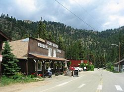
In the early 1890s, the Knapp family from Illinois built a sawmill near Harding Heights, then moved it first to Miller Fork and then to the point now known as Glen Haven in 1897. The Boulder Presbytery, with assistance from the Knapp family, formed an association in 1903 and sold lots for a summer resort called Glen Haven. The association built the Glen Haven General Store in 1921. [4] Under the direction of Ira Knapp, a lodge-style hotel was built called The Homestead, and opened in 1938. The Homestead became known as the Inn at Glen Haven and was mentioned in a Los Angeles Times travel article in 1986. [5] The Trail's End camps of Cheley Colorado Camps are also located near Glen Haven. [6]

Glen Haven's location in a narrow valley puts the area at risk for flooding. The Big Thompson Flood of 1976 moved the town hall several feet off its foundation. [7] In September 2013, approximately 80 percent of Glen Haven's downtown was destroyed in the 2013 Colorado floods. [8] [9] Access to the town was cut off by the destruction of Larimer County Road 43 on both sides of town; the section connecting to the town of Drake and US 34 was reopened on December 6, 2013. [10]

Further reading

Related Research Articles

Larimer County, Colorado County in Colorado, United States

Larimer County is a county located in the U.S. state of Colorado. As of the 2020 census, the population was 359,066. The county seat and most populous city is Fort Collins. The county was named for William Larimer, Jr., the founder of Denver.

Gold Hill, Colorado Census Designated Place in Colorado, United States

Gold Hill is an unincorporated community and a census-designated place (CDP) located in and governed by Boulder County, Colorado, United States. The CDP is a part of the Boulder, CO Metropolitan Statistical Area. The population of the Gold Hill CDP was 230 at the United States Census 2010. The Boulder post office serves the area.

Estes Park, Colorado Town in Colorado, United States

Estes Park is a statutory town in Larimer County, Colorado, United States. The town population was 5,904 at the 2020 United States Census. Estes Park is a part of the Fort Collins, CO Metropolitan Statistical Area and the Front Range Urban Corridor. A popular summer resort and the location of the headquarters for Rocky Mountain National Park, Estes Park lies along the Big Thompson River. Landmarks include The Stanley Hotel and The Baldpate Inn. The town overlooks Lake Estes and Olympus Dam.

Loveland, Colorado City in Colorado, United States

The City of Loveland is the home rule municipality that is the second most populous municipality in Larimer County, Colorado, United States. Loveland is situated 46 miles (74 km) north of the Colorado State Capitol in Denver and is the 14th most populous city in Colorado. As of the 2020 census the population of Loveland was 76,378. The city forms part of the Fort Collins-Loveland Metropolitan Statistical Area and the Front Range Urban Corridor. The city's public schools are part of the Thompson R2-J School District.

Big Thompson River

The Big Thompson River is a tributary of the South Platte River, approximately 78 miles (123 km) long, in the U.S. state of Colorado. It originates in Forest Canyon into Lake Estes, in Estes Park, CO. It includes four crossings/bridges which are listed on the U.S. National Register of Historic Places.

Trail Ridge Road Colorado Scenic and Historic Byway

Trail Ridge Road is the name for the 48-mile (77 km) stretch of U.S. Highway 34 that traverses Rocky Mountain National Park from Estes Park, Colorado in the east to Grand Lake, Colorado in the west. Together with the connecting 6.9-mile (11 km) Beaver Meadow Road, Trail Ridge Road forms the 55-mile (89 km) Trail Ridge Road/Beaver Meadow National Scenic Byway, an All-American Road. With a high point at 12,183 feet (3,713 m) elevation, Trail Ridge Road is the highest continuous paved road in North America. The higher portion of Trail Ridge Road is closed from October to May.

Mummy Range

The Mummy Range is a mountain range in the Rocky Mountains of northern Colorado in the United States. The range is a short subrange of the Front Range located in southwestern Larimer County northwest of the town of Estes Park. It is located largely within Rocky Mountain National Park, extending north from Trail Ridge Road approximately 15 miles (24 km). The Arapaho name is "nooku-bee3ei-no," which translates to "White Owls."

Lawn Lake Dam

Lawn Lake Dam was an earthen dam in Rocky Mountain National Park, United States that failed on July 15, 1982, at about 6 a.m., in an event known as the flood of 1982. The sudden release of 30 million cubic feet of water resulted in a flash flood that killed three people camping in the park and caused $31 million in damage to the town of Estes Park, Colorado and other downstream areas.

Camp Collins was a 19th-century outpost of the United States Army in the Colorado Territory. The fort was commissioned in the summer of 1862 to protect the Overland Trail from attacks by Native Americans in a conflict that later became known as the Colorado War. Located along the Cache la Poudre River in Larimer County, it was relocated from its initial location near Laporte after a devastating flood. Its second location downstream on the Poudre was used until 1866 and became the nucleus around which the City of Fort Collins was founded.

North Central Colorado Urban Area Metropolitan area of Colorado

The North Central Colorado Urban Area comprises the four contiguous metropolitan statistical areas in the north central region of the State of Colorado: the Denver–Aurora Metropolitan Statistical Area, the Boulder Metropolitan Statistical Area, the Fort Collins-Loveland Metropolitan Statistical Area, and the Greeley Metropolitan Statistical Area. With the exception of southeastern Elbert County, southeastern Park County, and tiny portions of southern Douglas County, the entire North Central Colorado Urban Area is drained by the South Platte River and its tributaries. The North Central Colorado Urban Area is the central, and the most populous, of the three primary subregions of the Front Range Urban Corridor.

The Trail Ridge Road/Beaver Meadow National Scenic Byway is a 55-mile (89 km) All-American Road and Colorado Scenic and Historic Byway located in Rocky Mountain National Park in Larimer and Grand counties, Colorado, USA. The byway consists of the 48-mile (77 km) Trail Ridge Road and the connecting 6.9-mile (11 km) Beaver Meadow Road. With a high point at 12,183 feet (3,713 m) elevation, Trail Ridge Road is the highest continuous paved road in North America. The higher portion of Trail Ridge Road is closed from October to May. The Rocky Mountain National Park Administration Building is a National Historic Landmark.

U.S. Highway 36 is a major east–west route in the U.S. state of Colorado, extending from Rocky Mountain National Park to the Kansas state line.

Salina, Colorado

Salina is a former mining town in Boulder County, Colorado, United States approximately 7 miles (11 km) west of Boulder. Established in 1874, after Colorado's first gold discovery in 1859, Salina was founded by miners who migrated to Boulder from Salina, Kansas. It is located at the junction of Four Mile Canyon and Gold Run roads. The mining camp was originally accessible only by horseback or wagons pulled by mules but later became part of Colorado's Switzerland Trail when the Greeley, Salt Lake, & Pacific narrow gauge railroad was built in the early 1880s. Today, most of Salina's original structures still stand, including the one-room schoolhouse, Salina School, and church, the Little Church in the Pines, despite some impact from the Fourmile Canyon wildfire in 2010 and historic flooding during the 2013 Colorado floods.

2012 Colorado wildfires

The 2012 Colorado wildfires were an unusually devastating series of Colorado wildfires, including several separate fires that occurred throughout June, July, and August 2012. At least 34,500 residents were evacuated in June.

2013 Colorado floods

The 2013 Colorado floods were a series of natural disasters occurring in the U.S. state of Colorado. Starting on September 11, 2013, a slow-moving cold front stalled over Colorado, clashing with warm humid monsoonal air from the south. This resulted in heavy rain and catastrophic flooding along Colorado's Front Range from Colorado Springs north to Fort Collins. The situation intensified on September 11 and 12. Boulder County was worst hit, with 9.08 inches (231 mm) recorded September 12 and up to 17 inches (430 mm) of rain recorded by September 15, which is comparable to Boulder County's average annual precipitation. This event has also been referred to as the 2013 Colorado Front Range Flood, reflecting a more precise geographic extent in and along the Colorado Front Range mountains.

History of Rocky Mountain National Park began when Paleo-Indians traveled along what is now Trail Ridge Road to hunt and forage for food. Ute and Arapaho people subsequently hunted and camped in the area. In 1820, the Long Expedition, led by Stephen H. Long for whom Longs Peak was named, approached the Rockies via the Platte River. Settlers began arriving in the mid-1800s, displacing the Native Americans who mostly left the area voluntarily by 1860, while others were removed to reservations by 1878.

Horseshoe Park

Horseshoe Park is a flat at 8,524 feet (2,598 m) in elevation in Larimer County, Colorado. It is within the Rocky Mountain National Park, which lies between Estes Park to the east and Grand Lake, Colorado on the west. Horseshoe Park is home to bighorn sheep, elk and other wildlife, and it is a wetland sanctuary for wide variety of birds. Recreational activities include picnicking, hiking, cross-country skiing and snowshoeing. Roaring River, Lawn Lake and Crystal Lake are located here.

Cameron Peak Fire

The Cameron Peak fire was a wildfire that started near Chambers Lake, Colorado, 25 miles (40.2km) east of Walden and 15 miles (24.1km) southwest of Red Feather Lakes near Cameron Pass on August 13, 2020, and was declared 100% contained on December 2, 2020. The fire burnt 208,663 acres through the Arapaho and Roosevelt National Forests in Larimer and Jackson Counties and Rocky Mountain National Park. At its peak, the fire forced the evacuation of over 6,000 residents in Estes Park, Chambers Lake, Rustic, Glacier View Meadows, Red Feather Lakes, Masonville, Glen Haven, Spring Canyon, various small communities along Highway 14, Stove Prairie Landing Road, as well as the Colorado State University Mountain Campus and had over 1,000 personnel fighting the fire. 469 structures were destroyed by the fire, including 220 outbuildings and 42 primary residences. The fire became the largest wildfire in Colorado history, surpassing the Pine Gulch Fire, which had set the same mark just seven weeks prior.

Cheley Colorado Camps is a traditional, residential summer camp, in the Estes Park Valley. Cheley is located at three unique sites: Land O'Peaks Ranch in Estes Park, Colorado, which houses three girls' units and three boys' units, and Trail's End Ranch for Boys and Trail's End Ranch for Girls in Glen Haven, Colorado. Since 1921, Cheley Colorado Camps has welcomed more than 50,000 young people from every state and more than a dozen countries, including many second, third, and fourth generation Cheley campers. Offering two traditional 4-week terms for 9-17-year-olds, a 5-night program for 7-10-year-old campers, a family camp, and more, Cheley hosts over 1,200 campers each summer. Often appearing on "best summer camps" lists, it is internationally renowned.

References

  1. 1 2 "US Board on Geographic Names". United States Geological Survey. 2007-10-25. Retrieved 2008-01-31.
  2. 1 2 "ZIP Code Lookup". United States Postal Service. December 15, 2006. Archived from the original (JavaScript/HTML) on November 22, 2010. Retrieved December 15, 2006.
  3. David, Olinger (1 Jan 2014). "Many Glen Haven homeowners still homeless months after flood". Denver Post. Retrieved 24 Mar 2014. But the seemingly insurmountable problem is access to the network of dirt roads linking hundreds of houses in the woods.... The town needs at least $2 million to rebuild private roads that ran along two creeks.
  4. Sumonia, Duke (16 Aug 1990). "The Inn of Glen Haven" (PDF). Estes Valley Library. Archived from the original (PDF) on 25 March 2014. Retrieved 24 Mar 2014.
  5. Hulse, Jerry (7 Sep 1986). "Memories Live On at Inns Gracing the Hillsides of Rocky Mountain Village". Los Angeles Times. Retrieved 24 Mar 2014.
  6. "Program On Cheley Camp At Estes Park Museum". Estes Park News. 26 Jul 2013. p. 7. Retrieved 24 Mar 2014. Trail's End for Boys and Trail's End for Girls camps near Glen Haven began in 1937 and 1941, respectively, and are focused on horsemanship.
  7. Hughes, Trevor (24 Sep 2013). "Glen Haven community recovering after severe flood damage". The Coloradan. Retrieved 24 Mar 2014.
  8. David, Olinger (3 Oct 2013). "Three weeks after Colorado floods, tiny Glen Haven waits for help". Denver Post. Retrieved 24 Mar 2014.
  9. Dokoupil, Tony (18 Oct 2013). "Colorado floods: A month later, mountain towns 'spooky' and deserted". NBC News. Retrieved 24 Mar 2014.
  10. Young, Craig (19 Dec 2013). "Glen Haven chips away at obstacles after the flood". Estes Park Trail Gazette. Retrieved 24 Mar 2014.