Lovelaceville, Kentucky

Last updated

Lovelaceville, Kentucky
USA Kentucky location map.svg
Red pog.svg
Lovelaceville, Kentucky
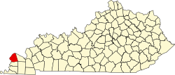
Location within the state of Kentucky
Coordinates: 36°58′3″N88°49′55″W / 36.96750°N 88.83194°W / 36.96750; -88.83194
Country United States
State Kentucky
County Ballard
Area
[1]
  Total
0.51 sq mi (1.32 km2)
  Land0.51 sq mi (1.31 km2)
  Water0.01 sq mi (0.01 km2)
Elevation
374 ft (114 m)
Population
 (2020)
  Total
124
  Density245.54/sq mi (94.81/km2)
Time zone UTC-6 (Central (CST))
  Summer (DST) UTC-5 (CST)
ZIP code
42060
Area code(s) 270 & 364
FIPS code 21-48072
GNIS feature ID2629642 [2]

Lovelaceville is a census-designated place (CDP) in Ballard County, Kentucky, United States. The population was 124 at the 2020 census. [3] The town is named after Elias and Andrew Lovelace who settled and raised their families there back around 1830. The Lovelace family came from North and South Carolina, after immigrating from England.

Contents

Demographics

Historical population
CensusPop.Note
2020 124
U.S. Decennial Census [4]

As of the 2010 census, there were 373 households with a population density of 48. The average household size was 2.53, [5] with 94.11% of the population of white, 2.27% black, 0.31% Asian, 0.31% Native American, and 3% claiming 'Other' ethnicity and 3.93% of the people in Lovelaceville claiming Hispanic ethnicity. [6]

Climate

The climate in this area is characterized by hot, humid summers and generally mild to cool winters. According to the Köppen Climate Classification system, Lovelaceville has a humid subtropical climate, abbreviated "Cfa" on climate maps. [7]

Related Research Articles

<span class="mw-page-title-main">Woodville, Florida</span> CDP in Florida, United States

Woodville is a census-designated place in Leon County, Florida, United States, just south of Tallahassee, Florida. The population was 4,097 at the 2020 census, up from 2,978 at the 2010 census. It is part of the Tallahassee, Florida Metropolitan Statistical Area. The American Civil War Battle of Natural Bridge, in March 1865, occurred in what is now Woodville, at the Natural Bridge. This is where the St. Marks River drops into a sinkhole, the Natural Bridge Sink and flows underground, reemerging .25 miles (0.40 km) later.

Fort Campbell North is a census-designated place (CDP) in Christian County, Kentucky, United States. It contains most of the housing for the Fort Campbell Army base within the Kentucky portion of the base. The population was 12,825 as of the 2020 census, down from 13,685 in the 2010 census.

Fairdale is a former census-designated place in southern Jefferson County, Kentucky, United States. The population was 7,658 at the 2000 census. In 2003, the area was annexed to the city of Louisville due to a merger between the city and Jefferson County's unincorporated community. Fairdale is now a neighborhood within the city limits of Louisville. The ZIP Code for Fairdale is 40118.

<span class="mw-page-title-main">Hodgenville, Kentucky</span> City in Kentucky, United States

Hodgenville is a home rule-class city in LaRue County, Kentucky, United States. It is the seat of its county. Hodgenville sits along the North Fork of the Nolin River. The population was 3,206 at the 2010 census. It is included in the Elizabethtown metropolitan area.

<span class="mw-page-title-main">Hyden, Kentucky</span> City in Kentucky, United States

Hyden is a home rule-class city in and the county seat of Leslie County, Kentucky, United States. The population was 365 at the 2010 census. It is located at the junction of U.S. Route 421 and Kentucky Route 80, along the Middle Fork of the Kentucky River.

<span class="mw-page-title-main">Kuttawa, Kentucky</span> City in Kentucky, United States

Kuttawa is a home rule-class city in Lyon County, Kentucky, in the United States. The population was 649 as of the 2010 census, up from 596 in 2000.

<span class="mw-page-title-main">Stearns, Kentucky</span> Census-designated place in Kentucky, United States

Stearns is an unincorporated community and census-designated place (CDP) in McCreary County, Kentucky, United States. The population was 1,365 at the 2020 census. It was founded by Justus Smith Stearns.

<span class="mw-page-title-main">Calhoun, Kentucky</span> City in Kentucky, United States

Calhoun is a home rule-class city in McLean County, Kentucky, United States. The population was 725 at the 2020 census. It is the county seat of McLean County. It is included in the Owensboro, Kentucky Metropolitan Statistical Area.

<span class="mw-page-title-main">Springfield, Kentucky</span> City in Kentucky, United States

Springfield is a home rule-class city in and the county seat of Washington County, Kentucky, United States. The population was 2,846 at the 2020 census.

<span class="mw-page-title-main">Atlanta, Michigan</span> Census-designated place in Michigan, United States

Atlanta is a census-designated place and unincorporated community in the U.S. state of Michigan. It is the county seat of Montmorency County. The community had a population of 720 at the 2020 census, down from 827 in 2010. Atlanta has been nicknamed the "Elk Capital of Michigan".

<span class="mw-page-title-main">Hickory Flat, Mississippi</span> Town in Mississippi, United States

Hickory Flat is a town in Benton County, Mississippi, United States. The population was 601 at the 2010 census.

Horsham is a census-designated place in Horsham Township, Montgomery County, Pennsylvania, United States. The population was 15,193 at the 2020 census. It is home to the Biddle Air National Guard Base at the former site of Naval Air Station Joint Reserve Base Willow Grove.

<span class="mw-page-title-main">Frankston, Texas</span> Town in Texas, United States

Frankston is a town in Anderson County, Texas, United States. With a population of 1,126 at the 2020 United States census, it is one of the most populous communities of the county area.

<span class="mw-page-title-main">New Summerfield, Texas</span> City in Cherokee County, Texas, United States

New Summerfield is a city in Cherokee County, Texas, United States. The population was 843 at the 2020 U.S. census.

<span class="mw-page-title-main">Italy, Texas</span> Town in Texas, United States

Italy is a town in Ellis County, Texas, United States. Its population was 1,926 in 2020. The community was named after Italy by a settler who had visited the European country.

<span class="mw-page-title-main">Grapeland, Texas</span> City in Texas, United States

Grapeland is a city in Houston County, Texas, United States. Its population was 1,465 as of the 2020 census.

<span class="mw-page-title-main">Emory, Texas</span> City in Texas, United States

Emory is a city in Rains County, Texas, United States. The population was 1,239 at the 2010 census. It is the county seat of Rains County. Previously known as Springville, the city and county are named after Emory Rains, who was a legislator from the area. Rains was the author of the Homestead Law of Texas, which was later used as a model for the protection of homesteads throughout the United States. Special legislation passed to create Rains County called for the citizens to vote on the location of the county seat and for that selected town to be named Emory.

<span class="mw-page-title-main">Tye, Texas</span> City in Texas, United States

Tye is a city in Taylor County, Texas, United States. Its population was 1,176 at the 2020 census. It is part of the Abilene, Texas metropolitan statistical area.

<span class="mw-page-title-main">Woodville, Texas</span> Town in and county seat of Tyler County, Texas, United States

Woodville is a town in and the county seat of Tyler County, Texas, United States. The town is intersected by three U.S. Numbered Highways: U.S. Route 69, U.S. Route 190, and U.S. Route 287. The population was 2,403 at the 2020 census. It is the county seat of Tyler County. The town was named after George Tyler Wood, governor of Texas from 1847 to 1849.

<span class="mw-page-title-main">Lake Bridgeport, Texas</span> City in Texas, United States

Lake Bridgeport is a city in Wise County, Texas, United States. The population was 339 in 2020.

References

  1. "2020 U.S. Gazetteer Files". United States Census Bureau. Retrieved March 18, 2022.
  2. U.S. Geological Survey Geographic Names Information System: Lovelaceville, Kentucky
  3. "Lovelaceville CDP, Kentucky". www.census.gov. Retrieved November 10, 2023.
  4. "Census of Population and Housing". Census.gov. Retrieved June 4, 2016.
  5. "2010 Census Gazetteer Files". www.census.gov. Archived from the original on February 20, 2011. Retrieved June 6, 2022.
  6. "Census.gov". www.census.gov. United States Census Bureau.
  7. "Lovelaceville, Kentucky Köppen Climate Classification (Weatherbase)". Weatherbase.