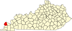
Ceredo | |
---|---|
Unincorporated community | |
Coordinates: 37°2′28″N88°52′1″W / 37.04111°N 88.86694°W Coordinates: 37°2′28″N88°52′1″W / 37.04111°N 88.86694°W | |
Country | United States |
State | Kentucky |
County | Ballard |
Elevation | 423 ft (129 m) |
Time zone | Central (CST) (UTC-6) |
• Summer (DST) | CST (UTC-5) |
GNIS feature ID | 507681 [1] |
Ceredo is an unincorporated community located in Ballard County, Kentucky, United States.
In law, an unincorporated area is a region of land that is not governed by a local municipal corporation; similarly an unincorporated community is a settlement that is not governed by its own local municipal corporation, but rather is administered as part of larger administrative divisions, such as a township, parish, borough, county, city, canton, state, province or country. Occasionally, municipalities dissolve or disincorporate, which may happen if they become fiscally insolvent, and services become the responsibility of a higher administration. Widespread unincorporated communities and areas are a distinguishing feature of the United States and Canada. In most other countries of the world, there are either no unincorporated areas at all, or these are very rare; typically remote, outlying, sparsely populated or uninhabited areas.
Ballard County is a county located in the U.S. state of Kentucky. As of the 2010 census, the population was 8,249. Its county seat is Wickliffe. The county was created by the Kentucky State Legislature in 1842 and is named for Captain Bland Ballard, a soldier, statesman, and member of the Kentucky General Assembly. Ballard is now as of late 2017 a wet county
Kentucky, officially the Commonwealth of Kentucky, is a state located in the east south-central region of the United States. Although styled as the "State of Kentucky" in the law creating it, (because in Kentucky's first constitution, the name state was used) Kentucky is one of four U.S. states constituted as a commonwealth. Originally a part of Virginia, in 1792 Kentucky became the 15th state to join the Union. Kentucky is the 37th most extensive and the 26th most populous of the 50 United States.
Wayne County is the westernmost county in the U.S. state of West Virginia. As of the 2010 census, the population was 42,481. Its county seat is Wayne. The county was founded in 1842 and named for General "Mad" Anthony Wayne.
Johnson County is a county located in the U.S. state of Kentucky. As of the 2010 census, the population was 23,356. Its county seat is Paintsville. The county was formed in 1843 and named for Richard Mentor Johnson, War of 1812 general, United States Representative, Senator, and Vice President of the United States. Johnson County is classified as a moist county, which is a county in which alcohol sales are not allowed, but containing a "wet" city, in this case Paintsville, where alcoholic beverage sales are allowed.
Paintsville is a home rule-class city along Paint Creek in Johnson County, Kentucky, in the United States. It is the seat of its county. The population was 3,459 during the 2010 U.S. Census.
Ceredo is a town in Wayne County, West Virginia, United States, along the Ohio River. The population was 1,450 at the 2010 census. Ceredo is a part of the Huntington-Ashland, WV-KY-OH Metropolitan Statistical Area (MSA). As of the 2000 census, the MSA had a population of 288,649.
Kenova is a city in Wayne County, West Virginia, at the confluence of the Ohio and Big Sandy Rivers. Located near a tristate border, the city's name is a portmanteau of Kentucky, Ohio, and Virginia (Va). Founded in 1859 but not incorporated until 1894, the town's early history and development was centered on the railroad industry. It is home to a major Norfolk Southern Ohio River Bridge. CSX Transportation's former Chesapeake and Ohio Kanawha Subdivision travels through the town as well.
Wayne is a town in Wayne County, West Virginia, United States. The population was 1,413 at the 2010 census. It is the county seat of Wayne County. Wayne is a part of the Huntington-Ashland, WV-KY-OH, Metropolitan Statistical Area. As of 2015, the MSA had a population of 361,580.
Eli Thayer was a member of the United States House of Representatives from 1857 to 1861. He was born in Mendon, Massachusetts. He graduated from Worcester Academy in 1840, from Brown University in 1845, and in 1848 founded Oread Institute, a school for young women in Worcester, Massachusetts. He is buried at Hope Cemetery, Worcester.
Ceredo may refer to:
Sant'Anna d'Alfaedo is a comune (municipality) in the Province of Verona in the Italian region Veneto, located about 110 kilometres (68 mi) west of Venice and about 20 kilometres (12 mi) north of Verona. As of 31 December 2004, it had a population of 2,544 and an area of 43.7 square kilometres (16.9 sq mi).
The 5th West Virginia Volunteer Infantry Regiment was an infantry regiment that served in the Union Army during the American Civil War.
Mitch Stadium is a baseball field located on the boundary line between the Town of Ceredo and the City of Kenova in West Virginia. It is home to the Ceredo-Kenova Little League and numerous annual community events. The stadium was created in 1955 and is named in honor of Elmer "Big Mitch" Mitchell, who served as groundskeeper at the facility for 27 years until his death in 1981. The facility at Mitch Stadium has previously hosted concerts, youth football and soccer events, and community carnivals and festivals. "The Mitch" has hosted 7 West Virginia Little League State Tournaments, the 1965 Little League Divisional Tournament, the 2009 Little League 2009 Little League Southeast Regional Baseball and Softball Tournaments, and serves as the host of the Little League 9-10 Year-Old Tournament of State Champions.
Thomas Edward Dandelet was an American football and basketball coach. He served as the head football coach at college football coach at the First District Agricultural School—now known as Arkansas State University—from 1922 to 1923 and at Marshall College—now known as Marshall University—from 1931 to 1934, compiling a career college football record of 18–29–3. Dandelet was also the head basketball coach at Marshall from 1931 to 1935, tallying a mark of 43–35.
Charles Brooks Hoard was a U.S. Representative from New York.
The Huntington–Ashland metropolitan area is the largest metropolitan statistical area in West Virginia and includes seven counties across three states: West Virginia, Kentucky, and Ohio. New definitions from February 28, 2013 placed the population at 361,580. The MSA is nestled along the banks of the Ohio River within the Appalachian Plateau region. The area is referred to locally as the "Tri-State area". In addition, the three largest cities are referred to as the River Cities.
The Tournament of State Champions (TOSC) is an annual Little League Baseball tournament featuring 8-10-year-old and 9-11-year-old state champions. The 8-10 tournament was first held in August 2005 at Mitch Stadium, located upon the town borders of Ceredo, West Virginia and Kenova, West Virginia. The 9-11 tournament was first held in August 2010 at Elm Street Park, located in Greenville, NC. The fifteenth annual 8-10 Tournament of State Champions is scheduled to be held in Greenville, North Carolina in 2019. The tenth annual 9-11 Tournament of State Champions is scheduled to be held in Greenville, North Carolina in 2019.
Wayne Bromley "Rasty" Wright was a professional baseball pitcher. He played all or part of five seasons in Major League Baseball for the St. Louis Browns between 1917 and 1923.
The Tri-State Bruisers were a women's semi-professional football team based in the Huntington–Ashland, WV–KY–OH, Metropolitan Statistical Area. As members of the Women's Spring Football League, the Bruisers play their home games at the historic Ward-Craycraft Stadium in Kenova, West Virginia, former home of the Ceredo-Kenova Wonders, a 12-time state Class AA Champion. They will be sharing their home field with the Ceredo-Kenova Crash, a men's semi-professional team.
The Tri-State Transit Authority (TTA), which markets itself as "THE Transit Authority, is the city bus system in Huntington, West Virginia, and Ironton, Ohio, as well as its suburbs. Its buses range, on the West Virginia side from 21st Street in Kenova, WV to Milton, West Virginia, about 20 miles to the east. On the Ohio side the buses range from downtown Ironton to the Huntington suburb of Proctorville, Ohio, which is also a range of about 20 miles. Interchange buses provide links between Huntington and Chesapeake, Ohio, and between Ironton and Ashland, Kentucky, where transfers are available to the Ashland Bus System (ABS). However the system does not interchange between the TTA and ABS in Ceredo, West Virginia, even though the buses pass within a few blocks of one another.
Ashland Bus System (ABS) provides the municipal bus service in the City of Ashland, Kentucky and its nearby suburbs. Unlike many such services, it is operated by the city government itself. Its routes also reach the suburbs, including Ceredo, West Virginia and Kenova, West Virginia. This is a result of a dispute between those twin cities, and the West Virginia and Ohio bus system known as the Tri-State Transit Authority, known as TTA.
Z. D. Ramsdell House, also known as The Ramsdell House, is a historic home located at Ceredo, Wayne County, West Virginia, atop a mound claimed to be an Indian burial mound. It was built in 1857-1858, and is a two-story red brick and frame dwelling measuring 30 feet wide and 48 feet deep. It sits on a stone foundation and is in the Greek Revival-style with a gable roof. Zophar D. Ramsdell came to Ceredo at the invitation of the town's founder, and fellow abolitionist, Eli Thayer. He built a shoe and boot factory, served as a Captain and Quartermaster during the American Civil War, served as a postmaster after the war, and served as a legislative representative in the West Virginia State Senate during 1868 and 1869. The home is believed to be one of the last stops of The Underground Railroad before crossing the Ohio River to freedom. It is open as a historic house museum.
This Ballard County, Kentucky state location article is a stub. You can help Wikipedia by expanding it. |