Pennington County is a county in the U.S. state of South Dakota. As of the 2020 census, the population was 109,222, making it the second most populous county in South Dakota. Its county seat is Rapid City. The county was created in 1875, and was organized in 1877. It is named for John L. Pennington, fifth Governor of Dakota Territory, who held office in 1875 when the county was formed.

Fall River County is a county in the U.S. state of South Dakota. As of the 2020 census, the population was 6,973. Its county seat is Hot Springs. The county was founded in 1883. It is named for Fall River which runs through it.

Dewey County is a county in the U.S. state of South Dakota. As of the 2020 census, the population was 5,239. Its county seat is Timber Lake. The county was created in 1883 and organized in 1910. It was named for William P. Dewey, Territorial surveyor-general from 1873 to 1877.

Custer County is a county in the U.S. state of South Dakota. As of the 2020 census, the population was 8,318. Its county seat is Custer. The county was created in 1875, and was organized in 1877. It was named after General George Armstrong Custer.
Corson County is a county in the U.S. state of South Dakota. As of the 2020 census, the population was 3,902. Its county seat is McIntosh. The county was named for Dighton Corson, a native of Maine, who came to the Black Hills in 1876, and in 1877 began practicing law at Deadwood.

Edgemont is a city in Fall River County, South Dakota, United States. The population was 725 at the 2020 census. The city lies on the far southern edge of the Black Hills in southwestern South Dakota.

U.S. Highway 16 (US 16) is an east–west United States Numbered Highway between Rapid City, South Dakota, and Yellowstone National Park in Wyoming. The highway's eastern terminus is at a junction with Interstate 90 (I-90)/US 14, concurrent with I-190, in Rapid City. The western terminus is the east entrance to Yellowstone National Park, concurrent with US 14 and US 20. US 16 used to extend all the way to Michigan but has been truncated in favor of I-90 and I-96.

U.S. Highway 18 (US 18) is an east–west United States Numbered Highway in the Midwestern United States. The western terminus is in Orin, Wyoming, at an interchange with Interstate 25 (I-25). Its eastern terminus is in Downtown Milwaukee, Wisconsin. US 18, however, runs concurrent with other U.S. Highways from its western terminus to Mule Creek Junction, Wyoming. US 18 is one of the original U.S. Highways of 1926. The US 18 designation was originally proposed for a road in Michigan from Grand Haven east to Detroit. This roadway was eventually designated as US 16.

South Dakota Highway 471 (SD 471) is a 21.981-mile (35.375 km) state highway in western Fall River, South Dakota, United States, that connects Highway 71 (SD 71), southeast of Rumford, with U.S. Route 18 (US 18), in Edgemont.
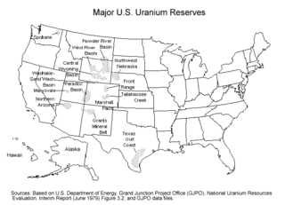
Uranium mining in the United States produced 224,331 pounds (101.8 tonnes) of U3O8 in 2023, 15% of the 2018 production of 1,447,945 pounds (656.8 tonnes) of U3O8. The 2023 production represents 0.4% of the uranium fuel requirements of the US's nuclear power reactors for the year. Production came from five in-situ leaching plants, four in Wyoming (Nichols Ranch ISR Project, Lance Project, Lost Creek Project, and Smith Ranch-Highland Operation) and one in Nebraska (Crowe Butte Operation); and from the White Mesa conventional mill in Utah.

Uranium mining in Colorado, United States, goes back to 1872, when pitchblende ore was taken from gold mines near Central City, Colorado. The Colorado uranium industry has seen booms and busts, but continues to this day. Not counting byproduct uranium from phosphate, Colorado is considered to have the third largest uranium reserves of any US state, behind Wyoming and New Mexico.

Uranium mining in Wyoming was formerly a much larger industry than it is today. Wyoming once had many operating uranium mines, and still has the largest known uranium ore reserves of any state in the U.S. At the end of 2008, the state had estimated reserves dependent on price: 539 million pounds of uranium oxide at $50 per pound, and 1,227 million pounds at $100 per pound.
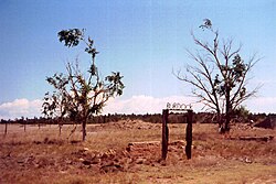
Argentine Township is one of the three townships of Fall River County, South Dakota, United States; most of the rest of the county is unorganized territory. The township lies in the northwestern corner of the county, on the Wyoming border. Burdock lies in the center of the township.
Maverick Junction, South Dakota, United States, is an unincorporated community and census-designated place (CDP) located in Fall River County at the intersection of South Dakota Highway 79 and US Highways 18 and 385, approximately five miles southeast of Hot Springs. The population was 46 at the 2020 census.

Dewey is an unincorporated community near the southwest corner of Custer County, South Dakota, United States, less than one mile from the Wyoming border in a prairie region of the Black Hills. There are approximately five or six homes in town. Dewey has a volunteer fire department in the Edgemont city district.

South Dakota Highway 71 (SD 71) is a 34.535-mile (55.579 km) state highway in Fall River County, South Dakota, United States, that travels from the Nebraska state line to U.S. Route 18 Bypass in Hot Springs. It is part of a triple state highway serving South Dakota, Nebraska, and Colorado.

The Elk Mountains are a small range of mountains in western South Dakota, forming the southwest portion of the Black Hills as part of its west-dipping monocline. They are geologically distinct from the Black Hills, on the other side of a "racetrack" region of red stone. The ridge of the Elk Mountains is formed of harder sandstones. The east face of the Elk Mountains is a 300-to-800-foot high escarpment, but the west portion falls slowly and features many canyons.

U.S. Route 385 (US 385) is a part of the United States Numbered Highway System that travels from Big Bend National Park in Texas to US 85 in Deadwood, South Dakota. Within the state of Nebraska, the highway is known as the Gold Rush Byway, one of nine scenic byways across the state. The highway follows along the old Sidney-Black Hills trail which played a crucial role during the Black Hills Gold Rush in the late 1870s. It served as the primary route to transport gold and mining gear between Sidney, Nebraska and the Black Hills to the north. Today, the highway enters Nebraska in the southeastern portion of the Nebraska Panhandle on the state line with Colorado northeast of Julesburg and continues in a northerly direction to the South Dakota state line north of Chadron.

A yellowcake boomtown also known as a uranium boomtown, is a town or community that rapidly increases in population and economics due to the discovery of uranium ore-bearing minerals, and the development of uranium mining, milling or enrichment activities. After these activities cease, the town "goes bust" and the population decreases rapidly.