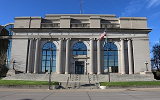
Pennington County is a county in the U.S. state of South Dakota. As of the 2020 census, the population was 109,222, making it the second most populous county in South Dakota. Its county seat is Rapid City. The county was created in 1875, and was organized in 1877. It is named for John L. Pennington, fifth Governor of Dakota Territory, who held office in 1875 when the county was formed.
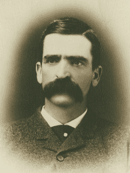
Seth Bullock was a Canadian-American frontiersman, business proprietor, politician, sheriff, and U.S. Marshal. He was a prominent citizen in Deadwood, South Dakota, where he lived from 1876 until his death, operating a hardware store and later a large hotel, the Bullock Hotel.

The Payette River is an 82.7-mile-long (133.1 km) river in southwestern Idaho and is a major tributary of the Snake River.

Rockerville is a small unincorporated community in Pennington County in the Black Hills of the U.S. state of South Dakota. Originally established as a mining camp, it was named for the "rockers" which were used to separate placer gold from stream gravel.
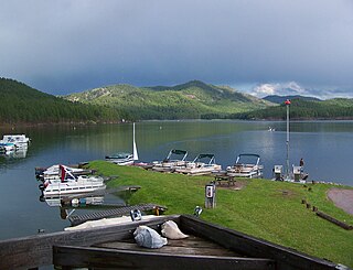
Sheridan Lake, a reservoir, is located on Spring Creek in Pennington County, South Dakota. Built over the site of Sheridan, the first county seat, it is owned and operated by the United States Forest Service and is one of the recreational areas of the Black Hills National Forest.
Three Forks is an unincorporated community in Pennington County, South Dakota, United States. It lies at the intersection of U.S. Routes 16 and 385, just north of Hill City along Spring Creek. A small general store featuring fuel is open year-round; other businesses are open seasonally, including a campground, a motel, a miniature golf-course, and an ice-cream stand. The campground is the site of an annual Octoberfest event, and the area is heavily patronized during the Sturgis Motorcycle Rally in August of each year. In recent years, considerable residential development of the immediate area has swollen its population.

Silver City is an unincorporated community in Pennington County, South Dakota, United States, outside Rapid City. It lies at the head of Pactola Lake on Rapid Creek, and is about 5 miles west of U.S. Route 385 via a paved county road. It is not tracked by the U.S. Census Bureau.
Carbonate, also known as Carbonate Camp, West Virginia, Virginia, and Carbonate City, is a ghost town located in Lawrence County, South Dakota, United States.
Addie Camp, also known as Kennedyville, Addie Spur, or Canadaville, is a ghost town located in Pennington County, South Dakota, United States. It was a mining camp in the Black Hills that was active from the early 1880s until the 1910s.
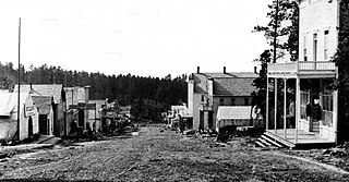
Tigerville or Tiger City (1878–1885) is a ghost town in the Black Hills of Pennington County, South Dakota, United States. The old mining town exemplifies the boom-and-bust fate of many Western towns.
Flatiron, formerly known as Yellow Creek or Flat Iron City, is a ghost town in Lawrence County, South Dakota, United States. It was known for its highly successful gold mining.
Pactola, also known as Camp Crook, (1875–1950s) is a ghost town in Pennington County, South Dakota, United States. It was an early placer mining town and existed into the early 1950s, when it was submerged under Pactola Lake.
Rochford is an unincorporated community in Pennington County, South Dakota, United States. It is not tracked by the U.S. Census Bureau.
Roubaix, formerly known as Perry or Lewisville, is an unincorporated community in Lawrence County, South Dakota, United States. It is not monitored by the U.S. Census Bureau.
Galena is an unincorporated community in Lawrence County, South Dakota, United States. It is often considered to be a ghost town, although a few families still live in the area. It is not tracked by the U.S. Census Bureau.

Terraville is a ghost town in Lawrence County, South Dakota, United States. It was founded in 1877 as a mining camp and later evolved into a town. It was purchased by the Homestake Mining Company and was destroyed in 1982 to make way for a new mine.
The Cripple Creek Gold Rush was a period of gold production in the Cripple Creek area from the late 1800s until the early 1900s. Mining exchanges were in Cripple Creek, Colorado Springs, Pueblo and Victor. Smelting was in Gillett, Florence, and (Old) Colorado City. Mining communities sprang up quickly, but most lasted only as long as gold continued to be produced. Settlements included:

Mystic is a ghost town in Pennington County, South Dakota. It began as a placer mining encampment called Sitting Bull in 1876, later attracting multiple railroads to the area. Its population began to decline in the early 20th century, and it now has few to no permanent residents. The old townsite was added to the National Register of Historic Places in 1986 under the name Mystic Townsite Historic District.

