The Black Hills Flood of 1972,also known as the Rapid City Flood,was the most detrimental flood in South Dakota history,and one of the deadliest floods in U.S. history. The flood took place on June 9–10,1972 [1] in the Black Hills of Western South Dakota. 15 inches (380 mm) of rain in a small area over the Black Hills caused Rapid Creek and other waterways to overflow. Severe flooding of residential and commercial properties in Rapid City occurred when Canyon Lake Dam became clogged with debris and failed in the late evening hours of June 9 resulting in 238 deaths and 3,057 injuries. [2] Over 1,335 homes and 5,000 automobiles were destroyed. The value of property damage was estimated to be over US$160 million in 1972 dollars ($1.17 billion in 2023 dollars [3] ). Flooding also occurred in Battle,Spring,Bear Butte,and Boxelder creeks. [4]
A few days before the Rapid City Flood,"earlier rains had left the soil saturated,increasing the amount of runoff of the flood to come." [4] On the afternoon of June 9,substantial rains fell on the area,caused by "an almost stationary group of thunderstorms." [4]
Additionally,"a strong low-level easterly flow which forced the moist unstable air up-slope on the hills. This sustained orographic effect helped the air to rise,cool,and release its moisture in repeating thunderstorms. Another contributing factor was the unusually light winds at a higher atmospheric levels which did not disperse the moist air nor move the thunderstorms along to prevent an extreme concentration of rainfall." [4]
According to Herbert Thompson the air pattern causing this storm was noticed in big measure over the Great Plains,with a minor scale to the east of the Rockies. There were only what appeared to be light winds,so nothing indicated that there was a huge storm underway. Thompson further indicates that a cold high pressure region was pushed from Canada into the Great Lakes region leading into the western part of South Dakota. A "mesoscale cloud mass" from Colorado also moved towards Rapid City. [5] One of the cloud masses amplified the "mid-level moisture over Rapid City," while the other mass caused the pressure to stay,as the high pressure pushed downward,thus creating the right conditions to produce rainfall. [6] The rainfall from the upper "cloud mass" above the Black Hills formed into new smaller masses downwind which reprocessed the rain allowing for the constant rainfall. [7] The storm was described by Nair,Hjelmfelt,and Pielke as "convective cells of high precipitation efficiency a characteristic of tropical precipitation systems. [1] Cloud seeding experiments being conducted by the Institute of Atmospheric Sciences on clouds west of Rapid City were speculated to have contributed to the unusual amount of rain. However,there is no evidence that the two phenomena were related. [8]
The immense precipitation was based over the "Rapid,Boxelder,Spring,and Battle Creeks," creating run-off,along these creeks which led to flooding throughout the surrounding areas. [1]
The intense rain began on the afternoon of June 9 and continued until after midnight on June 10. The immense amount of rain the Black Hills received during the thunderstorms ranged from 4 to 15 inches,causing Rapid Creek and surrounding creeks to overflow and creating massive amounts of runoff that resulted in flood waters. The run-off carried rubble to the Canyon Lake Dam creating a barrier in front of its spillway. [4] This resulted in the "increase in depth of water behind the dam of 11 to 12 feet," which caused the release of more water adding to the already moving floodwaters. [9] The flash flood hit Rapid City the hardest around midnight on June 9;the flood waters also hit the small town of Keystone nearby. [4]
The flood caused a tremendous amount of damage. Flood waters displaced large rocks,trees,trailers,and vehicles,and carried homes away. [10] In Rapid City the flood resulted in the deaths of "238 including 5 missing," 14 of the deaths were trained professionals. [11] The flood resulted in over 3,000 people being injured. A total of 1,335 homes were ruined,and 2,820 homes were damaged. More than 200 businesses were ruined,and around 5,000 cars were demolished. The damage in Rapid City totaled $66 million in 1972 dollar value. [11] As for Keystone,"eight people were killed and much of the town was washed away." [4] The damage in Keystone totaled around $1.5 million. [11] The total cost of the 1972 Black Hills flood totaled $165 million,including infrastructure and utilities. The total amount of rain the Black Hills received was "800,000 acre feet" equal to "1 billion metric tons of water." [11]
The National Weather Service Office (NWS) in Rapid City in 1972 was taking hourly surface observations,issuing local storm warnings and providing local forecasts to the media. The personnel in Rapid City were not properly trained to make forecasts or use the technologies available to them. [12] They lacked access to vital weather information to warn the area citizens.
The Rapid City National Weather Service is now a forecast office with a full-time staff of meteorologists who issue both forecasts and warnings for northeastern Wyoming and the western third of South Dakota. In 1972, the National Weather Service office in Rapid City did not have a teletype system to broadcast warnings. They instead used a one-way telephone hotline to the media to broadcast the warnings. Today warnings are sent to a regional site where they are sent to the National Oceanic and Atmospheric Administration (NOAA) Weather Wire System satellite. NWS forecasters use the state radio system to notify 9-1-1 dispatchers and emergency personnel. This warning is also passed on to the Emergency Alert System (EAS).
In the aftermath of the 1972 flood, short-term and long-term programs were put into effect. Many businesses were permitted to stay in the flood plain, but houses and motels were either raised or moved due to the likelihood that a flood would occur while a person may be sleeping. The majority of the flood plain was made into large parks, which have increased in number and have been improved and updated on a continuing basis. Canyon Lake Dam and most bridges were redesigned to prevent debris clogs during flooding.
![]() | This section is written like a personal reflection, personal essay, or argumentative essay that states a Wikipedia editor's personal feelings or presents an original argument about a topic.(September 2021) |
Victims lost precious memories as stated in the Rapid City newspaper. An excerpt from the newspaper reads, "Operation Family Treasure' may provide hope for people.' For those who have given up all hope about finding a priceless photo album or sheet of important personal papers there may be a happy ending with "Operation Family Treasure," a clearing house for irreplaceable items run by the Rapid City Jaycees in conjunction with the Office of Civil defense. Flood disaster victims advised on tax breaks." [13] Eldon L. Smith, a South Dakota state senator, was a victim of the flood. [14]
2012 saw the 40 year anniversary of the fateful flood. Survivors remarked on the horrific events. Rita, who was 20 at the time, described the scene, "There was so many [people] in trees and screaming and crying and the sparks were flying from electric wires, houses were on fire, it was just — it was hell," she says. Rita was seven months pregnant at the time of the tragedy. She describes her fears as, "I wouldn't wish that upon nobody," she says. "That's a nightmare and a half to think that you're going to die in water and your mom is gonna go with you and you're trying to do your best to keep your mom alive." Rita and her mother were swept against a building and thankfully rescued. There were others with the same experience while others were worse. Good Samaritans like Alex were left to clean up the mess and search for the less fortunate. He describes a gruesome scene, "I found a boy about 5 years old," Alex says. "He was dead, laying on some debris. I didn't touch him or nothing, I just went back and told the authorities where he was at. Then I quit." [15]
One unidentified resident of Rapid City, which was flooded, spoke to a reporter after the flood. "...the only thing above water is the hilltops. I guess it just ... I guess we gotta couple troubles." [16]
Another survivor said: "My house is no more. You can see it over there, there's the, well, there just isn't anything." [16]
And another unidentified survivor added: "A man knocked at our door and said, 'Get out as fast as you can.' We grabbed the children and my dad's crippled and we picked him up and put him in the car, and just as we drove out the driveway, a big trailer started floating right across the pathway, and we just made it up the hill and that was all it was. Everything was gone." [16]
One source, Sean Potter, Certified Consulting Meteorologist and Certified Broadcast Meteorologist, wrote, "I called my best advisor, Mr. Leonard Swanson, the City Public Works Director, and we met at City Hall. Heavy rains were falling, and Mr. Swanson and I drove to Canyon Lake Park where a city worker and his family lived in the park caretaker's home, immediately below the dam. Swanny ordered the caretaker, a Parks Department employee, to immediately take his family, leave their evening meal on the table and get out of the park. The entire family survived the flood. Not a trace of the home (it was city property) or the contents was ever found. [17]
A flood is an overflow of water that submerges land that is usually dry. In the sense of "flowing water", the word may also be applied to the inflow of the tide. Floods are of significant concern in agriculture, civil engineering and public health. Human changes to the environment often increase the intensity and frequency of flooding. Examples for human changes are land use changes such as deforestation and removal of wetlands, changes in waterway course or flood controls such as with levees. Global environmental issues also influence causes of floods, namely climate change which causes an intensification of the water cycle and sea level rise. For example, climate change makes extreme weather events more frequent and stronger. This leads to more intense floods and increased flood risk.
A thunderstorm, also known as an electrical storm or a lightning storm, is a storm characterized by the presence of lightning and its acoustic effect on the Earth's atmosphere, known as thunder. Relatively weak thunderstorms are sometimes called thundershowers. Thunderstorms occur in a type of cloud known as a cumulonimbus. They are usually accompanied by strong winds and often produce heavy rain and sometimes snow, sleet, or hail, but some thunderstorms produce little precipitation or no precipitation at all. Thunderstorms may line up in a series or become a rainband, known as a squall line. Strong or severe thunderstorms include some of the most dangerous weather phenomena, including large hail, strong winds, and tornadoes. Some of the most persistent severe thunderstorms, known as supercells, rotate as do cyclones. While most thunderstorms move with the mean wind flow through the layer of the troposphere that they occupy, vertical wind shear sometimes causes a deviation in their course at a right angle to the wind shear direction.
Rapid City is a city in South Dakota, United States, and the county seat of Pennington County. It is the second most populous city in the state, after Sioux Falls. It is located on the eastern slope of the Black Hills in western South Dakota and was named after Rapid Creek, where the settlement developed. The population was 74,703 as of the 2020 census.
A flash flood is a rapid flooding of low-lying areas: washes, rivers, dry lakes and depressions. It may be caused by heavy rain associated with a severe thunderstorm, hurricane, or tropical storm, or by meltwater from ice and snow. Flash floods may also occur after the collapse of a natural ice or debris dam, or a human structure such as a man-made dam, as occurred before the Johnstown Flood of 1889. Flash floods are distinguished from regular floods by having a timescale of fewer than six hours between rainfall and the onset of flooding.
The National Severe Storms Laboratory (NSSL) is a National Oceanic and Atmospheric Administration (NOAA) weather research laboratory under the Office of Oceanic and Atmospheric Research. It is one of seven NOAA Research Laboratories (RLs).
This article describes severe weather terminology used by the National Weather Service (NWS) in the United States, a government agency operating within the Department of Commerce as an arm of the National Oceanic and Atmospheric Administration (NOAA).
Hurricane Javier was a powerful tropical cyclone whose remnants brought above-average rainfall totals across the western United States in September 2004. Javier was the tenth named storm, the sixth hurricane and the final major hurricane of the 2004 Pacific hurricane season. Javier was also the strongest hurricane of the 2004 season, with 150 mph (240 km/h) winds and a central pressure of 930 millibars. However, because of high wind shear in the East Pacific, Javier weakened rapidly before making landfall in Baja California as a tropical depression. The remnants of the storm then continued moving northeast through the Southwestern United States. Javier caused no direct fatalities, and the damage in Mexico and the United States was minimal.
A flash flood warning is a severe weather warning product of the National Weather Service that is issued by national weather forecasting agencies throughout the world to alert the public that a flash flood is imminent or occurring in the warned area. A flash flood is a sudden, violent flood after a heavy rain, or occasionally after a dam break. Rainfall intensity and duration, topography, soil conditions, and ground cover contribute to flash flooding.
Floods in the United States are generally caused by excessive rainfall, excessive snowmelt, and dam failure. Below is a list of flood events that were of significant impact to the country during the 20th century, from 1900 through 1999, inclusive.
Tropical Storm Norma was the fourteenth named tropical cyclone of the 1970 Pacific hurricane season. The storm formed off the coast of Mexico and intensified rapidly, peaking as a strong tropical storm on September 3, before starting a weakening trend. It dissipated before making landfall on Baja California.
This article describes severe weather terminology used by the Meteorological Service of Canada, a branch within Environment and Climate Change Canada. The article primarily describes various weather warnings, and their criteria. Related weather scales and general weather terms are also addressed in this article. Some terms are specific to certain regions.
In weather forecasting in the United States, "particularly dangerous situation" (PDS) is enhanced wording used by the National Weather Service to convey special urgency in some watch or warning messages for unusually extreme and life-threatening severe weather events, above and beyond the average severity for the type of event. It is used in the format "This is a particularly dangerous situation..." at the discretion of the issuing forecaster. A watch or warning bearing the phrase is referred to as a PDS watch or PDS warning as shorthand jargon.
The 2003 Melbourne thunderstorm was a severe weather event that occurred over the city of Melbourne, Australia, and surrounding areas of Victoria, from 1 to 6 December 2003. The Australian Bureau of Meteorology called the storm a "once in 100-year event".
Severe weather is any dangerous meteorological phenomenon with the potential to cause damage, serious social disruption, or loss of human life. These vary depending on the latitude, altitude, topography, and atmospheric conditions. High winds, hail, excessive precipitation, and wildfires are forms and effects, as are thunderstorms, downbursts, tornadoes, waterspouts, tropical cyclones, and extratropical cyclones. Regional and seasonal phenomena include blizzards (snowstorms), ice storms, and duststorms.
A flash flood watch is severe weather watch product of the National Weather Service that is issued when conditions are favorable for flash flooding in flood-prone areas, usually when grounds are already saturated from recent rains, or when upcoming rains will have the potential to cause a flash flood. These watches are also occasionally issued when a dam may break in the near future.
A Special Weather Statement is a form of weather advisory. Special Weather Statements are issued by the National Weather Service of the United States (NWS) and the Meteorological Service of Canada (MSC). There are no set criteria for special weather statements in either country.
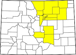
The 2013 Colorado floods were a series of natural disasters occurring in the U.S. state of Colorado. Starting on September 11, 2013, a slow-moving cold front stalled over Colorado, clashing with warm humid monsoonal air from the south. This resulted in heavy rain and catastrophic flooding along Colorado's Front Range from Colorado Springs north to Fort Collins. The situation intensified on September 11 and 12. Boulder County was worst hit, with 9.08 inches (231 mm) recorded September 12 and up to 18 inches (460 mm) of rain recorded by September 15, which is comparable to Boulder County's average annual precipitation. This event has also been referred to as the 2013 Colorado Front Range Flood, reflecting a more precise geographic extent in and along the Colorado Front Range mountains.
Hurricane Linda was a strong tropical cyclone in September 2015 that resulted in heavy rains across portions of Mexico and the Southwestern United States. The seventeenth named storm, eleventh hurricane, and eighth major hurricane of the season, Linda developed southwest of Mexico from a low-pressure area on September 5. Under warm sea surface temperatures and low to moderate wind shear, the system intensified into Tropical Storm Linda by September 6 and a hurricane by the next day. A well-defined eye soon formed within the storm's central dense overcast and Linda reached its peak intensity as a 125 mph (205 km/h) Category 3 major hurricane on the Saffir–Simpson hurricane wind scale on September 8. Thereafter, the storm moved into a stable environment and an area of lower sea surface temperatures, causing rapid weakening. Convective activity dissipated and Linda degenerated into a remnant low on September 10. The lingering system persisted southwest of Baja California, ultimately opening up into a trough on September 14.
A black nor'easter is a persistent and potentially violent north-easterly storm that occurs on the east coast of Australia, particularly from southeastern Queensland to southern New South Wales, usually between late spring and early autumn, about two days a year.