
Corpus Christi is a coastal city in the South Texas region of the U.S. state of Texas and the county seat and largest city of Nueces County with portions extending into Aransas, Kleberg, and San Patricio counties. It is 130 miles (210 km) southeast of San Antonio and 208 miles (335 km) southwest of Houston. Its political boundaries encompass Nueces Bay and Corpus Christi Bay. Its zoned boundaries include small land parcels or water inlets of three neighboring counties.

South Texas is a region of the U.S. state of Texas that lies roughly south of—and includes—San Antonio. The southern and western boundary is the Rio Grande, and to the east it is the Gulf of Mexico. The population of this region is about 4.96 million according to the 2017 census estimates. The southern portion of this region is often referred to as the Rio Grande Valley. The eastern portion along the Gulf of Mexico is also referred to as the Coastal Bend.

Abilene State Park is a 529.4-acre (214.2 ha) state park next to Lake Abilene about 15 miles (24 km) southwest of Abilene, Texas on FM 89. The park opened on May 10, 1934 and is managed by the Texas Parks and Wildlife Department.

Wall Doxey State Park is a public recreation area located off Mississippi Highway 7, seven miles (11 km) south of Holly Springs, Mississippi. The state park is centered on 60-acre (24 ha) Spring Lake. It is named for white Democrat politician Wall Doxey.

Corpus Christi Bay is a scenic semi-tropical bay on the Texas coast found in San Patricio and Nueces counties, next to the major city of Corpus Christi. It is separated from the Gulf of Mexico by Mustang Island, and is fed by the Nueces River and Oso Creek from its western and southern extensions, Nueces Bay and Oso Bay. The bay is located approximately 136 miles (219 km) south of San Antonio, and 179 miles (288 km) southwest of Houston.

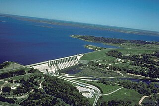
Choke Canyon Reservoir is a reservoir in South Texas, United States. The lake and the dam that creates it are owned by the United States Bureau of Reclamation and managed by the City of Corpus Christi.

Lake Corpus Christi is a reservoir in coastal southern Texas. The lake was created by impoundment of the Nueces River by the Wesley E. Seale Dam opened in 1958. The lake and the dam that creates it are managed by the City of Corpus Christi. Lake Corpus Christi was originally known as Lake Lovenskiold. It is often referred to as Lake Mathis because of its location.

Promised Land State Park is a Pennsylvania state park in Blooming Grove, Greene and Palmyra Townships, Pike County, Pennsylvania, in the United States. The approximately 3,000-acre (1,214 ha) park is mostly surrounded by Delaware State Forest. It is in the Poconos and sits at an elevation of 1,800 feet (549 m). The second growth forests in Promised Land State Park are made up of beech, maple, oak and hemlock trees. There are two lakes within the boundaries of the park. Promised Land State Park is 10 miles (16 km) north of Canadensis on Pennsylvania Route 390.

Bastrop State Park is a state park in Bastrop County, Texas, United States. The park was established in 1933 and consists of stands of loblolly pines mixed with post oak and junipers.
Brackenridge Recreation Complex is a park operated by the Lavaca-Navidad River Authority. The park is a former state park in Texas then known as Lake Texana State Park and is located near Edna in Jackson County, halfway between Houston and Corpus Christi on Lake Texana.

Palmetto State Park is a state park located in Gonzales County, Texas, United States northwest of Gonzales and southeast of Luling. The land was acquired by deeds from private owners and the City of Gonzales in 1934–1936 and was opened in 1936.

Huntsville State Park is a 2,083.2-acre (843 ha) wooded recreational area, six miles (10 km) southwest of Huntsville, Texas, within Walker County and the Sam Houston National Forest.

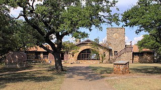
Davis Mountains State Park is a 2,709-acre (1,096 ha) state park located in the Davis Mountains in Jeff Davis County, Texas. The closest town is Fort Davis, Texas. The park elevation is between 5,000 and 6,000 ft above sea level. The original portion of the park was deeded to Texas Parks and Wildlife Department by a local family.

The Great Texas Coastal Birding Trail is a state-designated system of trails, bird sanctuaries, and nature preserves along the entire length of the Texas Gulf Coast in the United States. As the state of Texas hosts more bird species than any other state in the U.S. the trail system offers some of the most unusual opportunities for bird-watching in the world. The "trail" is actually 43 separate hiking and driving trails that include 308 birding sites. The sites themselves feature a variety of viewing opportunities with boardwalks, observation decks, and other amenities. The trails boast more than 450 bird species. The trail system is managed by the Texas Parks and Wildlife Department as part of the Great Texas Wildlife Trails which also include the Heart of Texas Wildlife Trail, the Panhandle Plains Wildlife Trail, and the Prairies and Pineywoods Wildlife Trail.

Daingerfield State Park is a 506.913-acre (2.05140 km2) state park in Morris County, Texas, southwest of Texarkana, including 80-acre (320,000 m2) Lake Daingerfield. The park opened in 1938 and is managed by the Texas Parks and Wildlife Department.

The Laguna Madre is a long, shallow, hypersaline lagoon along the western coast of the Gulf of Mexico in Nueces, Kenedy, Kleberg, Willacy and Cameron Counties in Texas, United States. It is one of seven major estuaries along the Gulf Coast of Texas. The roughly 20-mile (32 km) long Saltillo Flats land bridge divides it into Upper and Lower lagoons joined by the Intracoastal Waterway, which has been dredged through the lagoon. Cumulatively, Laguna Madre is approximately 130 miles (210 km) long, the length of Padre Island in the US. The main extensions include Baffin Bay in Upper Laguna Madre, Red Fish Bay just below the Saltillo Flats, and South Bay near the Mexican border. As a natural ecological unit, the Laguna Madre of the United States is the northern half of the ecosystem as a whole, which extends into Tamaulipas, Mexico approximately 144 miles (232 km) south of the US border, to the vicinity of the Rio Soto La Marina and the town of La Pesca, extending approximately 275 miles (443 km) through USA and Mexico in total.

Lake Ahquabi State Park is a state park of Iowa, US, featuring a 115-acre (47 ha) reservoir. Ahquabi means "resting place" in the Fox language. The park is 6 miles (9.7 km) south of Indianola and 22 miles (35 km) south of Des Moines. Three sections of the park were listed on the National Register of Historic Places in 1991.

Lockhart State Park is a state park located at the southwestern edge of Lockhart, Texas, United States and is administered by the Texas Parks and Wildlife Department. The park was constructed by Civilian Conservation Corps (CCC) Company 3803 between 1935 and 1938. The park officially became a state park in 1948.
Lake Brownwood State Park is a state park located on the shore of Lake Brownwood in Brown County, Texas, United States and is administered by the Texas Parks and Wildlife Department. The 537.5 acre park was acquired by deed from the Brown County Water Improvement District No. 1 in 1933. The Civilian Conservation Corps (CCC) developed the park between 1934 and 1942. The park opened in 1938.
Lake Whitney State Park is a state park located in Hill County, Texas, near Whitney, Texas. The park is 775 acres (314 ha).


