External links
| | This article related to a protected area in Texas is a stub. You can help Wikipedia by expanding it. |
| | This United States trail or long-distance path–related article is a stub. You can help Wikipedia by expanding it. |
| Heart of Texas Wildlife Trail | |
|---|---|
| Location | Central Texas |
| Use | Bird watching / hiking |
| Sights | Texas Hill Country, rivers, lakes |
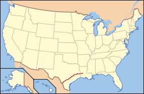
The Heart of Texas Wildlife Trail is a state-designated system of trails and wildlife sanctuaries in Central Texas in the United States. It is one of the four major wildlife trail systems designated by the State of Texas.
The trail system is divided into two main groupings of wildlife viewing sites. The first stretches from the Coleman area, near Abilene, through Austin and San Antonio, to Laredo. [1] The second is a cluster in the Texas Hill Country and southwest Rio Grande Valley bounded roughly by San Angelo, Del Rio, and Fredericksburg. [2]
| | This article related to a protected area in Texas is a stub. You can help Wikipedia by expanding it. |
| | This United States trail or long-distance path–related article is a stub. You can help Wikipedia by expanding it. |

Palo Pinto County is a county located in the U.S. state of Texas. As of the 2020 census, its population was 28,409. The county seat is Palo Pinto. The county was created in 1856 and organized the following year.

Brewster County is a county located in the U.S. state of Texas. It is in West Texas and its county seat is Alpine. It is one of the nine counties that comprise the Trans-Pecos region, and borders Mexico. Brewster County is the largest county by area in the state - at 6,192 square miles (16,040 km2) it is over three times the size of the state of Delaware, and more than 500 square miles (1,300 km2) bigger than Connecticut.

Fredericksburg is a city in and the seat of Gillespie County, Texas, United States. As of the 2010 Census, this city had a population of 10,530.

The Big Bend is part of the Trans-Pecos region in southwestern Texas, United States along the border with Mexico, north of the prominent bend in the Rio Grande for which the region is named. Here the Rio Grande passes between the Chisos Mountains in Texas and the Sierra Madre Oriental in Mexico as it changes from running east-southeast to north-northeast. The region covers three counties: Presidio County to the west, Brewster County to the east, and Jeff Davis County to the north.

Enchanted Rock is a pink granite mountain located in the Llano Uplift about 17 miles (27 km) north of Fredericksburg, Texas and 24 miles (39 km) south of Llano, Texas, United States. Enchanted Rock State Natural Area, which includes Enchanted Rock and surrounding land, spans the border between Gillespie and Llano counties, south of the Llano River. Enchanted Rock covers roughly 640 acres (260 ha) and rises around 425 feet (130 m) above the surrounding terrain to an elevation of 1,825 feet (556 m) above sea level. It is the largest pink granite monadnock in the United States. Enchanted Rock State Natural Area, a part of the Texas state park system, includes 1,644 acres (665 ha). In 1936, the area was designated a Recorded Texas Historic Landmark. In 1971, Enchanted Rock was designated as a National Natural Landmark by the National Park Service.

UT Health San Antonio is a public academic health science center in San Antonio, Texas. It is part of the University of Texas System.

Boquillas was a small settlement in Texas, United States, located on the northern banks of the Rio Grande. It was located within Brewster County, five miles (8 km) northeast of San Vicente. The place existed to service the mining operations at Boquillas del Carmen, Mexico, just across the Rio Grande.

Stephen F. Austin State Park is a 663.3 acres (268 ha) state park located on the Brazos River in San Felipe, Austin County, Texas, United States. The park is managed by the Texas Parks and Wildlife Department.

Bastrop State Park is a state park in Bastrop County, Texas, United States. The park was established in 1933 and consists of stands of loblolly pines mixed with post oak and junipers.

The Austin–Round Rock–San Marcos metropolitan statistical area, or Greater Austin, is a five-county metropolitan area in the U.S. state of Texas, as defined by the Office of Management and Budget. The metropolitan area is situated in Central Texas on the western edge of the American South and on the eastern edge of the American Southwest, and borders Greater San Antonio to the south.
The El Camino Real de los Tejas National Historic Trail is a national historic trail covering the U.S. section of El Camino Real de Los Tejas, a thoroughfare from the 18th-century Spanish colonial era in Spanish Texas, instrumental in the settlement, development, and history of Texas. The National Park Service designated El Camino Real de los Tejas National Historic Trail as a unit in the National Trails System in 2004.

The Rio Grande Trail is a proposed long distance trail along the Rio Grande in the U.S. state of New Mexico. The river extends over 1,800 total miles, some 700 miles (1,100 km) of which pass through the heart of New Mexico. It is the state's primary drainage feature and most valuable natural and cultural resource. The river and its bosque provide a wide variety of recreation, including hunting and fishing, birdwatching, river rafting, hiking, biking, and horseback riding. The river also flows through or beside numerous spectacular and geologically interesting landforms, the result of extensive volcanism and erosion of the valley within the Rio Grande Rift. Although some trail advocates would like to see the trail extended the full distance through New Mexico, from the Colorado border to the United States–Mexico border, the portion proposed for initial development extends 300 miles (480 km), from Bernalillo south to Las Cruces.

The Lower Rio Grande Valley National Wildlife Refuge is a 90,788-acre (367.41 km2) National Wildlife Refuge located in the Lower Rio Grande Valley region of southern Texas.

The Great Texas Coastal Birding Trail is a state-designated system of trails, bird sanctuaries, and nature preserves along the entire length of the Texas Gulf Coast in the United States. As the state of Texas hosts more bird species than any other state in the U.S. the trail system offers some of the most unusual opportunities for bird-watching in the world. The "trail" is actually 43 separate hiking and driving trails that include 308 birding sites. The sites themselves feature a variety of viewing opportunities with boardwalks, observation decks, and other amenities. The trails boast more than 450 bird species. The trail system is managed by the Texas Parks and Wildlife Department as part of the Great Texas Wildlife Trails which also include the Heart of Texas Wildlife Trail, the Panhandle Plains Wildlife Trail, and the Prairies and Pineywoods Wildlife Trail.
The Panhandle Plains Wildlife Trail is a state-designated system of trails and wildlife sanctuaries in the Texas Panhandle in the United States. It is one of the four major wildlife trail systems designated by the State of Texas.
The Prairies and Pineywoods Wildlife Trail is a state-designated system of trails and wildlife sanctuaries in the Texas Panhandle in the United States. It is one of the four major wildlife trail systems designated by the State of Texas.

Bentsen-Rio Grande Valley State Park is located at 2800 S. Bentsen Palm Drive south of the city of Mission in Hidalgo County in the U.S. state of Texas. It serves as the headquarters for the World Birding Center.
Resaca de la Palma State Park is one of three state parks belonging to the World Birding Center and managed by the Texas Parks and Wildlife Department. At 1,200 acres, Resaca de la Palma State Park is the largest of the World Birding Center sites and is located in Brownsville. The property was acquired by the Texas Parks and Wildlife Department in 1977 and was opened to the public in December 2008. A resaca is a type of oxbow lake that can be found in Texas, and is a former channels of the Rio Grande. It is naturally cut off from the river, having no inlet or outlet.