Inks Lake is a reservoir on the Colorado River in the Texas Hill Country in the United States. The reservoir was formed in 1938 by the construction of Inks Dam by the Lower Colorado River Authority. Located near Burnet, Texas, the lake serves to provide flood control in tandem with Lake Buchanan and features the smallest hydroelectric power plant on the Highland Lakes chain. Inks Lake was named for Roy B. Inks, one of the original board members of the Lower Colorado River Authority, and serves as a venue for outdoor recreation, including fishing, boating, swimming, camping, and picnicking.

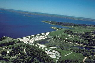
Lake Buchanan was formed by the construction of Buchanan Dam by the Lower Colorado River Authority to provide a water supply for the region and to provide hydroelectric power. Buchanan Dam, a structure over 2 mi (3.2 km) in length, was completed in 1939. Lake Buchanan was the first of the Texas Highland Lakes to be formed, and with 22,333 acres of surface water, it is also the largest. The surface of the lake includes area in both Burnet and Llano Counties. The lake is west of the city of Burnet, Texas.
Lake Houston is a reservoir on the San Jacinto River, 15 miles (24 km) northeast of downtown Houston, Texas, United States. The reservoir is the primary municipal water supply for the city of Houston.

Somerville Lake is a U.S. Army Corps of Engineers reservoir on Yegua Creek in the Brazos River basin, 10 miles (16 km) northwest of Brenham, Texas, United States. The town of Somerville in Burleson County is adjacent to the reservoir. The lake extends into portions of Burleson County, Washington County, and Lee County. The dam lies in Washington County. The dam and lake are managed by the Fort Worth District of the U.S. Army Corps of Engineers. The reservoir was officially impounded in 1967, and serves to provide flood control and water for irrigation for the communities downstream. Somerville Lake is a popular recreational destination.
Lake Whitney is a flood control reservoir on the main stem of the Brazos River in Texas. It is located on River Mile Marker 442 and controls drainage for 17,656 square miles (45,730 km2) of Texas and parts of New Mexico. The reservoir encompasses a surface area of more than 23,500 acres and 225 miles (362 km) of shoreline. The area consists of rolling, tallgrass prairies; cedar trees; hardwood timber; and 100 ft (30 m) bluffs and rock points. Lake Whitney is also part of the Texas Lakes Trail Region of North Texas.
Lake Wood was a reservoir on the Guadalupe River 4 miles (6 km) west of the town of Gonzales in Gonzales County, Texas. The reservoir was formed in 1931 by the construction of a dam to provide hydroelectric power to the area. Management of the dam and lake was assumed by the Guadalupe-Blanco River Authority on May 1, 1963. Lake Wood served as a venue for outdoor recreation, including fishing and boating.

Lake Casa Blanca is a reservoir on the Chacon Creek, 5 miles (8 km) northeast of downtown Laredo, Texas, United States. The reservoir was formed in 1951 by the construction of a dam to provide recreational opportunities for the residents of Webb County. The current dam is the second built across the creek - a previous dam built in 1946 failed the following year during the initial attempted impounding of a reservoir. There are residential properties along the lake as well as a Texas state park. Surrounding the lake is a 525-acre (212 ha) park that was operated jointly by the City of Laredo and Webb County before it was leased by the state in 1990 and opened in March 1991 as the Lake Casa Blanca International State Park. Lake Casa Blanca is fed by the Chacon Creek and San Ygnacio Creek.
Averhoff Reservoir is a 173-acre narrow, riverine-type reservoir located on the Nueces River 10 mi (16 km) north of the town of Crystal City in Zavala County, Texas, United States, and 100 miles from San Antonio, Texas.
Coleto Creek Reservoir is a reservoir on Coleto Creek and Perdido Creek located in Fannin, Texas, 15 miles (24 km) southwest of Victoria, Texas. The surface of the lake extends into Victoria and Goliad counties. The reservoir was formed in 1980 by the construction of a dam by the Guadalupe-Blanco River Authority to provide a power station cooling pond for electric power generation. Coleto Creek Reservoir is a venue for outdoor recreation, including fishing and boating.

Lake Corpus Christi is a reservoir in coastal southern Texas. The lake was created by impoundment of the Nueces River by the Wesley E. Seale Dam opened in 1958. The lake and the dam that creates it are managed by the City of Corpus Christi. Lake Corpus Christi was originally known as Lake Lovenskiold. It is often referred to as Lake Mathis because of its location.
Lake Texana is a reservoir on the Navidad River, 8 miles (13 km) east of Edna, in Jackson County, Texas. The reservoir is formed by the construction of Palmetto Bend Dam. The dam and lake are managed by the Lavaca-Navidad River Authority, and supply water to surrounding communities and industries. Lake Texana is the only reservoir managed by the Authority.

Stillhouse Hollow Lake is a U.S. Army Corps of Engineers reservoir on the Lampasas River in the Brazos River basin, 5 miles (8 km) southwest of Belton, Texas, United States. Stillhouse Hollow Dam and the reservoir are both managed by the Fort Worth District of the U.S. Army Corps of Engineers. The reservoir was officially impounded in 1968, and serves to provide flood control for the communities downstream. The lake also functions as a water supply for several of the surrounding communities. Stillhouse Hollow Lake is a popular recreational destination.

Belton Lake is a U.S. Army Corps of Engineers reservoir on the Leon River in the Brazos River basin, 5 miles (8 km) northwest of Belton, Texas, United States. The lake extends into both Bell County and Coryell County. Belton Dam and the lake are both managed by the Fort Worth District of the U.S. Army Corps of Engineers. The reservoir was officially impounded in 1954, and serves to provide flood control and drinking water for Belton, Temple, and the surrounding communities. Belton Lake is a popular recreational destination. In the fall of 2018 Lake Belton was host to the annual “Lonestar Throwdown” kayak fishing tournament. Teams from the North, South, Central, and West Texas regions battled it out for bragging rights and ultimately North Texas took home the coveted trophy.
Comanche Creek Reservoir is a 3,275-acre (13.3 km²) impoundment located between Glen Rose, Texas and Granbury, Texas. The primary purpose is cooling for Comanche Peak Nuclear Generating Station. During full operation of both units of Comanche Peak, 2.2 million US gallons (8,300 m3) of water are pumped through the plant's main condensers from Comanche Creek Reservoir.

Lake Tawakoni State Park is a state park located in Hunt County, Texas, United States, 11.2 miles (18.0 km) north of Wills Point. It is on the south central shore of Lake Tawakoni, a 37,879-acre reservoir on the Sabine River.
Lake Pueblo State Park is a state park located in Pueblo County, Colorado. It includes 60 miles (97 km) of shoreline and 10,000 acres (40 km2) of land. Activities it offers include two full-service marinas, recreational fishing, hiking, camping and swimming at a special swim beach.

O.C. Fisher Reservoir is an artificial lake located west of the city of San Angelo, Texas. With the financial support of the Upper Colorado River Authority, construction on the dam to form the reservoir was begun by the United States Army Corps of Engineers in 1947 and the lake was officially impounded in 1952. Originally named San Angelo Lake, the reservoir was renamed in 1975 for local U.S. Congressman O.C. Fisher, to honor his 23 years of service in the United States Congress.
Twin Buttes Reservoir is an artificial lake located about 6 mi (9.7 km) southwest of the city of San Angelo, Texas, and immediately upstream from Lake Nasworthy. Construction on Twin Buttes Dam to form the reservoir was completed in 1963. The dam is an unusual one – it dams the Middle and South Concho Rivers separately; a stabilization channel runs between the two sides of the lake. Water levels fell significantly during the 2010–13 Southern United States drought and remained low into 2014.
Kirby Lake is a 740-acre man-made reservoir located on the south side of Abilene, Texas, just east of Highway 83, in the northeastern portion of Taylor County. Kirby Lake is within the Brazos River Basin, meaning that Cedar Creek, which feeds Kirby Lake, eventually feeds into the Brazos River. Kirby Lake resides in the Red Prairies portion of the Central Great Plains ecoregion. Management is under the City of Abilene.

Lake Alan Henry is a reservoir situated in the upper Brazos River Basin in the United States. Created by the construction of the John T. Montford Dam in 1993, it is operated and used as a future tertiary water supply by the city of Lubbock, Texas and serves as a recreational spot for the region of West Texas. The surface area of the lake is 2,880 acres (1,170 ha) with a mean depth of 40 ft (12 m). Lake Alan Henry is located 4 mi (6.4 km) east of Justiceburg, Texas, and 45 mi (72 km) south of Lubbock.