
Brownsville is a city in the U.S. state of Texas and the seat of Cameron County, located on the western Gulf Coast in South Texas, adjacent to the border with Matamoros, Tamaulipas, Mexico. The city covers 145.2 sq mi (376.066 km2), and had a population of 186,738 at the 2020 census. As of the 2020 U.S. Census, it is the 139th-largest city in the United States and 18th-largest in Texas. It is part of the Matamoros–Brownsville metropolitan area. The city is known for its year-round subtropical climate, deep-water seaport, and Hispanic culture.
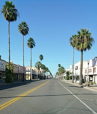
Weslaco is a city in Hidalgo County, Texas, United States. As of the 2020 census the population was 41,103, and in 2020 the estimated population was 40,160. It is located at the southern tip of Texas in the Rio Grande Valley near the Mexican border, across the Rio Grande from the city of Nuevo Progreso, Rio Bravo, Tamaulipas.

The Battle of Resaca de la Palma was one of the early engagements of the Mexican–American War, where the United States Army under General Zachary Taylor engaged the retreating forces of the Mexican Ejército del Norte under General Mariano Arista on May 9, 1846. The United States emerged victorious and forced the Mexicans out of Texas.

The Lower Rio Grande Valley, commonly known as the Rio Grande Valley or locally as the Valley or RGV, is a region spanning the border of Texas and Mexico located in a floodplain of the Rio Grande near its mouth. The region includes the southernmost tip of South Texas and a portion of northern Tamaulipas, Mexico. It consists of the Brownsville, Harlingen, Weslaco, Pharr, McAllen, Edinburg, Mission, San Juan, and Rio Grande City metropolitan areas in the United States and the Matamoros, Río Bravo, and Reynosa metropolitan areas in Mexico. The area is generally bilingual in English and Spanish, with a fair amount of Spanglish due to the region's diverse history and transborder agglomerations. It is home to some of the poorest cities in the nation, as well as many unincorporated, persistent poverty communities called colonias. A large seasonal influx occurs of "winter Texans" — people who come down from the north for the winter and then return north before summer arrives.
Resaca is the name given to a type of oxbow lake in the southern half of Cameron County, Texas. The resacas constitute former channels of the Rio Grande and are naturally cut off from the river, having no inlet or outlet.

The Arthur R. Marshall Loxahatchee National Wildlife Refuge is a 145,188-acre (587.55 km2) wildlife sanctuary is located west of Boynton Beach, in Palm Beach County, Florida. It is also known as Water Conservation Area 1 (WCA-1). It includes the most northern remnant of the historic Everglades wetland ecosystem.
Laguna Atascosa National Wildlife Refuge is the largest protected area of natural habitat left in the Lower Rio Grande Valley. The 120,000-acre (49,000 ha) refuge is located almost entirely in Cameron County, Texas, 25 mi (40 km) east of Harlingen, although a very small part of its northernmost point extends into southern Willacy County.

The Rio Grande Nature Center State Park is a New Mexico State Park located adjacent to the Rio Grande in Albuquerque, New Mexico, US. The Rio Grande Nature Center is a 38-acre urban wildlife preserve established in 1982. About two thirds of the grounds of the park are set aside as habitat for wildlife. The remaining acreage contains a visitors' center, two gardens, several wildlife viewing areas, an education building and a building housing the non-profit Wildlife Rescue, Inc. There are four constructed ponds which provide habitat for birds and other wildlife and which mimic wetland features of the historical flood plain of the Rio Grande.
Santa Ana National Wildlife Refuge is a 2,088-acre (8.45 km2) National Wildlife Refuge situated along the banks of the Rio Grande, south of Alamo in the Lower Rio Grande Valley, in Hidalgo County, South Texas.
The World Birding Center is the official title given to a combined nine parks and nature preserves in the Rio Grande Valley region of Texas managed by a partnership of the Texas Parks and Wildlife Department, the United States Fish and Wildlife Service, and the local communities in which the parks reside. The stated mission of the World Birding Center is to "protect native habitat while increasing the understanding and appreciation of the birds and wildlife", with an additional emphasis on promoting local economic development through ecotourism.

The Tamaulipan mezquital, also known as the Brush Country, is a deserts and xeric shrublands ecoregion in the Southern United States and northeastern Mexico. It covers an area of 141,500 km2 (54,600 sq mi), encompassing a portion of the Gulf Coastal Plain in southern Texas, northern Tamaulipas, northeastern Coahuila, and part of Nuevo León.

With a total area of 121,590 square miles (314,900 km2), New Mexico is the fifth-largest state, after Alaska, Texas, California, and Montana. Its eastern border lies along 103°W longitude with the state of Oklahoma, and 2.2 miles west of 103°W longitude with Texas. On the southern border, Texas makes up the eastern two-thirds, while the Mexican states of Chihuahua and Sonora make up the western third, with Chihuahua making up about 90% of that. The western border with Arizona runs along the 109° 03'W longitude. The southwestern corner of the state is known as the Bootheel. The 37°N parallel forms the northern boundary with Colorado. The states of New Mexico, Colorado, Arizona, and Utah come together at the Four Corners in New Mexico's northwestern corner. Its surface water area is about 292 square miles (760 km2).

The Resaca de la Palma Battlefield is the site in Brownsville, Texas, where American forces under General Zachary Taylor engaged Mexican forces under General Mariano Arista on May 9, 1846 in the Battle of Resaca de la Palma. A surviving undeveloped portion of the battlefield is now part of the Palo Alto Battlefield National Historical Park, and was designated a National Historic Landmark in 1960.

The Lower Rio Grande Valley National Wildlife Refuge is a 90,788-acre (367.41 km2) National Wildlife Refuge located in the Lower Rio Grande Valley region of southern Texas.

The Great Texas Coastal Birding Trail is a state-designated system of trails, bird sanctuaries, and nature preserves along the entire length of the Texas Gulf Coast in the United States. As the state of Texas hosts more bird species than any other state in the U.S. the trail system offers some of the most unusual opportunities for bird-watching in the world. The "trail" is actually 43 separate hiking and driving trails that include 308 birding sites. The sites themselves feature a variety of viewing opportunities with boardwalks, observation decks, and other amenities. The trails boast more than 450 bird species. The trail system is managed by the Texas Parks and Wildlife Department as part of the Great Texas Wildlife Trails which also include the Heart of Texas Wildlife Trail, the Panhandle Plains Wildlife Trail, and the Prairies and Pineywoods Wildlife Trail.

Seminole Canyon State Park and Historic Site is a state park in the U.S. state of Texas. It is located off U.S. Route 90, east of the Pecos River High Bridge, 9 miles (14 km) west of Comstock in Val Verde County. The park is conducive to camping, biking, bird watching, back packing and archeological study. Cave art and archeological artifacts date back to the earliest human habitation in the area. The park is part of the larger Seminole Canyon Archeological District on the National Register of Historic Places.

Bentsen-Rio Grande Valley State Park is located at 2800 S. Bentsen Palm Drive south of the city of Mission in Hidalgo County in the U.S. state of Texas. It serves as the headquarters for the World Birding Center.
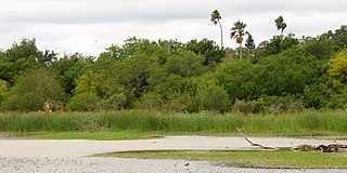
The Sabal Palm Sanctuary is a 557-acre (225-hectare) nature reserve and bird sanctuary located in the delta of the Rio Grande Valley in Cameron County near Brownsville, Texas. It is noted for being one of the last locations in the Rio Grande Valley with a profuse grove of sabal palms, an edible-heart-bearing palm much prized by pre-Hispanic inhabitants and noted by early explorers. As a relatively habitat-rich remnant of this Valley, it is a prized birdwatching and butterfly watching location for persons interested in the ecology of the Valley and adjacent states of northern Mexico.
The Valle de Oro National Wildlife Refuge is a protected area in New Mexico managed by the United States Fish and Wildlife Service as part of the National Wildlife Refuge System. It is located 7 miles (11 km) south of Albuquerque, New Mexico. This unit abuts the Rio Grande Valley State Park, which is adjacent to the Rio Grande.
Texan by Nature, originally formed in 2011 as Taking Care of Texas, is a 501(c)(3) nonprofit focusing on uniting business and conservation. Texan by Nature is headquartered at Austin, Texas.


