Fort Richardson (Texas)

Last updated
Fort Richardson
Fort Richardson.JPG
Looking across Fort Richardson's parade ground toward the hospital. The bakery, guardhouse and magazine are visible in the background.
Relief map of Texas.png
Red pog.svg
Fort Richardson
Usa edcp relief location map.png
Red pog.svg
Fort Richardson
Nearest city Jacksboro, Texas
Coordinates 33°12′29″N98°9′53″W / 33.20806°N 98.16472°W / 33.20806; -98.16472
Area42 acres (17 ha)
Built1867 (1867)
NRHP reference No. 66000816 [1]
TSAL No. 8200000387
Significant dates
Added to NRHPOctober 15, 1966
Designated NHLNovember 27, 1963 [2]
Designated TSHS1968 [3]
Designated TSALJanuary 1, 1983

Fort Richardson was a United States Army installation located in present-day Jacksboro, Texas. Named in honor of Union General Israel B. Richardson, who died in the Battle of Antietam [4] during the American Civil War, it was active from 1867 to 1878. Today, the site, with a few surviving buildings, is called Fort Richardson State Park, Historic Site and Lost Creek Reservoir State Trailway. It was designated a National Historic Landmark in 1963 for its role in securing the state's northern frontier in the post-Civil War era. [5]

Contents

History

As much as any frontier army installation, Fort Richardson facilitated white immigration and settlement in north-central Texas. It was part of a system of forts along the Texas frontier to protect and encourage settlement in north-central and West Texas. Others included Forts Griffin, Concho, Belknap, Chadbourne, Stockton, Davis, McKavett, Clark, McIntosh, Inge, and Phantom Hill in Texas, and Fort Sill in Oklahoma. [4] Some "subposts or intermediate stations" include Bothwick's Station on Salt Creek between Fort Richardson and Fort Belknap, Camp Wichita near Buffalo Springs between Fort Richardson and Red River Station, and Mountain Pass between Fort Concho and Fort Griffin. [6]

The original site selection was ordered for a location near Buffalo Springs in Clay County, about 20 miles (32 km) north of Fort Richardson. The location proved untenable and unfit for a semipermanent installation. The area lacked timber and adequate water resources, and the U.S. considered it "hostile" territory, with Native Americans often raiding the area. In 1862, an entire town, Henrietta, northwest of Buffalo Springs, was abandoned due to lack of security. As a result, the U.S. 6th Cavalry Regiment moved south to the present location of Fort Richardson.

In 1867, construction began by the 6th Cavalry on the 300-acre (120 ha) site along "Lost Creek, a small tributary of the West Fork of the Trinity River", [4] at a cost of $800,000, and occupied on 26 November. It became the anchor of the frontier fort system, and the last army outpost in North Texas along the military road to Fort Sill. "Originally a five-company post, it was expanded...to accommodate ten or more companies" [4] so that in 1872, with a population of 666 officers and men, it was listed as the largest U.S. Army installation in the United States. [7] Old-time cowboy author Frank H. Maynard spent time at Fort Richardson in 1872 when he had come to Jacksboro on a cattle drive. [8]

Units that occupied the fort included the 6th Cavalry Regiment, the 4th Cavalry Regiment, and the U.S. 11th Infantry Regiment, along with parts of the 10th Cavalry Regiment and 24th Infantry Regiment (United States), both Buffalo Soldier regiments. [7]

Life was hard for a soldier at Fort Richardson. Routine duties included long, arduous patrols along the frontier from Clay and Jack Counties west to Palo Duro Canyon near present-day Amarillo. Battles with Comanche and Kiowa Indians became commonplace as the U.S. cavalry and infantry units sought to prove their ability to repel attacks and facilitate white settlement.

In 1871 while touring the system, General William T. Sherman stayed at Fort Richardson and narrowly missed the Warren Wagon Train Raid. General Sherman arrived at Fort Sill and arrested Kiowa chiefs Satanta and Big Tree, and had them sent to Jacksboro to stand trial for their role in the massacre. In July 1871, they were tried, convicted, and sentenced to death, which was later commuted to life in prison. They were the first Indians tried and convicted in a Texas civil court system.

Following these events, General Sherman authorized the commander of the 4th Cavalry, Colonel Ranald S. Mackenzie, to begin offensive operations against the Comanche and Kiowa in the Texas Panhandle. One scouting party fought in the Battle of Palo Duro Canyon in September 1874, a U.S. victory that ended the Red River War with Quanah Parker's Comanches and Red Warbonnet's Kiowas. The cavalry captured so much of the tribes' provisions that they were forced to move back to reservations in Oklahoma before winter. This battle was largely responsible for the end to Comanche and Kiowa raids along the northern frontier between Oklahoma and Texas.

Abandonment and reuse

After its victory, the army saw no need to maintain Fort Richardson, so abandoned the post on May 23, 1878. [4] "It was used as an Indian school for a short time afterwards". [4] The 55 buildings, many made of stone and cottonwood lumber, fell into disrepair. Thanks to a group of Jacksboro residents, the fort was declared a state historic site in 1963 and came under the management of the Texas Parks and Wildlife Department. In 1968, extensive renovations began, and in 1973, it reopened as Fort Richardson State Historic Park.

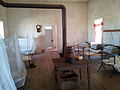
Today, it is called Fort Richardson State Park, Historic Site and Lost Creek Reservoir State Trailway. [9] Visitors can tour seven restored original buildings, including the post hospital, officers' quarters, powder magazine, morgue, commissary, guardhouse, and bakery. Two replica buildings of the enlisted men's barracks and the officer's barracks house the Interpretive Center. Guided tours of the buildings are held daily. [10]

See also

Related Research Articles

<span class="mw-page-title-main">Fort Stockton, Texas</span> City in Texas, United States

Fort Stockton is a city in and the county seat of Pecos County, Texas, United States. It is located on Interstate 10, future Interstate 14, U.S. Highways 67, 285, and 385, and the Santa Fe Railroad, 329 mi (529 km) northwest of San Antonio and 240 mi (390 km) southeast of El Paso. Its population was 8,466 at the 2020 census.

<span class="mw-page-title-main">Fort Concho</span> US Army fort in Texas, used 1867–1889

Fort Concho is a former United States Army installation and National Historic Landmark District located in San Angelo, Texas. It was established in November 1867 at the confluence of the North and South Concho Rivers, on the routes of the Butterfield Overland Mail Route and Goodnight–Loving Trail, and was an active military base for the next 22 years. Fort Concho was the principal base of the 4th Cavalry from 1867 to 1875 and then the "Buffalo Soldiers" of the 10th Cavalry from 1875 to 1882. The troops stationed at Fort Concho participated in Ranald S. Mackenzie's 1872 campaign, the Red River War in 1874, and the Victorio Campaign of 1879–1880.

<span class="mw-page-title-main">Fort McIntosh, Texas</span> United States historic place

Fort McIntosh was a U.S. Army base in Laredo, Webb County, Texas, from 1849 to 1946.

<span class="mw-page-title-main">Red River War</span> Military campaign launched by the United States Army in 1874

The Red River War was a military campaign launched by the United States Army in 1874 to displace the Comanche, Kiowa, Southern Cheyenne, and Arapaho tribes from the Southern Plains, and forcibly relocate the tribes to reservations in Indian Territory. The war had several army columns crisscross the Texas Panhandle in an effort to locate, harass, and capture nomadic Native American bands. Most of the engagements were small skirmishes with few casualties on either side. The war wound down over the last few months of 1874, as fewer and fewer Indian bands had the strength and supplies to remain in the field. Though the last significantly sized group did not surrender until mid-1875, the war marked the end of free-roaming Indian populations on the southern Great Plains.

<span class="mw-page-title-main">Fort Sill</span> United States army post in Lawton, Oklahoma

Fort Sill is a United States Army post north of Lawton, Oklahoma, about 85 miles (137 km) southwest of Oklahoma City. It covers almost 94,000 acres (38,000 ha).

<span class="mw-page-title-main">Fort Davis National Historic Site</span> National Historic Site of the United States

Fort Davis National Historic Site is a United States National Historic Site located in the unincorporated community of Fort Davis, Jeff Davis County, Texas. Located within the Davis Mountains of West Texas, the historic site was established in 1961 to protect one of the best remaining examples of a United States Army fort in the southwestern United States.

<span class="mw-page-title-main">Comanche history</span> History of Native American tribe

Comanche history is the story of the Native American (Indian) tribe which lived on the Great Plains of the present-day United States. In the 17th century the Eastern Shoshone people who became known as the Comanche migrated southward from Wyoming. In the 18th and 19th centuries the Comanche became the dominant tribe on the southern Great Plains. The Comanche are often characterized as "Lords of the Plains." They presided over a large area called Comancheria which they shared with allied tribes, the Kiowa, Kiowa-Apache, Wichita, and after 1840 the southern Cheyenne and Arapaho. Comanche power and their substantial wealth depended on horses, trading, and raiding. Adroit diplomacy was also a factor in maintaining their dominance and fending off enemies for more than a century. They subsisted on the bison herds of the Plains which they hunted for food and skins.

The Warren Wagon Train raid, also known as the Salt Creek massacre, occurred on May 18, 1871. Henry Warren was contracted to haul supplies to forts in the west of Texas, including Fort Richardson, Fort Griffin, and Fort Concho. Traveling down the Jacksboro-Belknap road heading towards Salt Creek Crossing, they encountered William Tecumseh Sherman. Less than an hour after encountering the famous General, they spotted a rather large group of riders ahead. They quickly realized that these were Native American warriors, probably Kiowa and/or Comanche.

<span class="mw-page-title-main">Fort Inge</span> United States historic place

Fort Inge was a frontier fort in Uvalde County, Texas, United States.

<span class="mw-page-title-main">Fort Griffin</span> United States historic place

Fort Griffin, now a Texas state historic site as Fort Griffin State Historic Site, was a US Cavalry fort established 31 July 1867 by four companies of the Sixth Cavalry, U.S. Army under the command of Lt. Col. S. D. Sturgis, in the western part of North Texas, specifically northwestern Shackelford County, to give settlers protection from early Comanche and Kiowa raids. Originally called Camp Wilson after Henry Hamilton Wilson, a recently deceased lieutenant and son of Radical Republican senator and later vice president, Henry Wilson, it was later named for Charles Griffin, a former Civil War Union general who had commanded, as de facto military governor, the Department of Texas during the early years of Reconstruction.

<span class="mw-page-title-main">Fort Chadbourne</span> United States historic place

Fort Chadbourne was a fort established by the United States Army on October 28, 1852, in what is now Coke County, Texas, to protect the western frontier and the Butterfield Overland Mail route. It was named after Lt. T.L. Chadbourne, who was killed in the Battle of Resaca de la Palma. It was defended by Companies A and K of the 8th U.S. Infantry. During the early days of the American Civil War, the fort surrendered to the Confederates on February 28, 1861, even before the Confederate shelling of Fort Sumter, South Carolina, but was reoccupied by federal troops from 1865 to 1867.

<span class="mw-page-title-main">Fort McKavett State Historic Site</span> United States historic place

The Fort McKavett State Historic Site is a former United States Army installation located in Menard County, Texas. The fort was first established in 1852 as part of a line of forts in Texas intended to protect migrants traveling to California. The fort was deemed unnecessary and abandoned in 1859 and was occupied by settlers. From 1861 to 1863, during the American Civil War, the fort became an outpost of Confederate forces on the Texas frontier until they left for other theaters of the war. When the US Army returned to Texas in the later 1860s, the fort was reoccupied and rebuilt, and became a base for the "Buffalo Soldier", or all-African American, 24th Infantry and 9th Cavalry Regiments.

The Texas–Indian wars were a series of conflicts between settlers in Texas and the Southern Plains Indians during the 19th-century. Conflict between the Plains Indians and the Spanish began before other European and Anglo-American settlers were encouraged—first by Spain and then by the newly Independent Mexican government—to colonize Texas in order to provide a protective-settlement buffer in Texas between the Plains Indians and the rest of Mexico. As a consequence, conflict between Anglo-American settlers and Plains Indians occurred during the Texas colonial period as part of Mexico. The conflicts continued after Texas secured its independence from Mexico in 1836 and did not end until 30 years after Texas became a state of the United States, when in 1875 the last free band of Plains Indians, the Comanches led by Quahadi warrior Quanah Parker, surrendered and moved to the Fort Sill reservation in Oklahoma.

<span class="mw-page-title-main">Trial of Satanta and Big Tree</span> 1871 trial of Native American War Chiefs

The Trial of Satanta and Big Tree occurred in May 1871 in the town of Jacksboro in Jack County, Texas, United States. This historic trial of Native American War Chiefs of the Kiowa Indians Satanta and Big Tree for the murder of seven teamsters during a raid on Salt Creek Prairie near Jacksboro, Texas, marked the first time the United States had tried Native American Chiefs in a state court. The trial attracted national and international attention. The two Kiowa leaders, with Satank, a legendary third War Chief, were formally indicted on July 1, 1871, and tried shortly thereafter, for acts arising out of the Warren Wagon Train Raid.

<span class="mw-page-title-main">Fort Belknap (Texas)</span> United States historic place

Fort Belknap, located near Newcastle, Texas, was established in November 1851 by brevet Brigadier General William G. Belknap to protect the Texas frontier against raids by the Kiowa and Comanche. It was the northernmost fort in a line from the Rio Grande to the Red River. The fort functioned as a base of operations rather than as a fortified point, and it became the center of a substantial network of roads, including the Butterfield Overland Mail. The fort was designated a National Historic Landmark in 1960, in recognition of its key role in securing the Texas frontier in the 1850s and 1860s.

<span class="mw-page-title-main">Fort Clark, Texas</span> United States historic place

Fort Clark was a frontier fort located just off U.S. Route 90 near Brackettville, in Kinney County, Texas, United States. It later became the headquarters for the 2nd Cavalry Division. The Fort Clark Historic District was added to the National Register of Historic Places on December 6, 1979. The Commanding Officer's Quarters at Fort Clark were designated a Recorded Texas Historic Landmark in 1988. The Fort Clark Guardhouse became a Recorded Texas Historic Landmark in 1962. The Fort Clark Officers' Row Quarters were designated a Recorded Texas Historic Landmark in 1991.

Mamante or Mamanti, also known as Swan was a Kiowa medicine man.

Big Red Meat was a Nokoni Comanche chief and a leader of Native American resistance against White invasion during the second half of the 19th century.

<span class="mw-page-title-main">Big Tree (Kiowa leader)</span>

Big Tree, Kiowa: Ado-ete, was a noted Kiowa warrior and chief. He was a loyal follower of the fighting chiefs party, and conducted frequent raids upon other tribes and white settlers, often being associated with Tsen-tainte.

<span class="mw-page-title-main">Blockhouse on Signal Mountain (Oklahoma)</span> Blockhouse on Signal Mountain in Southwest Oklahoma

Blockhouse on Signal Mountain is within the Fort Sill Military Reservation, north of Lawton, Oklahoma. The rock architecture is located along Mackenzie Hill Road within the Fort Sill West Range being the Oklahoma administrative division of Comanche County.

References

  1. "National Register Information System". National Register of Historic Places . National Park Service. July 9, 2010.
  2. Staff (June 2011). "National Historic Landmarks Survey: List of National Historic Landmarks by State (Texas)" (PDF). National Park Service. Retrieved December 17, 2017.
  3. "History, Fort Richardson State Park, Historic Site and Lost Creek Reservoir State Trailway". Texas Parks and Wildlife Department . Retrieved December 17, 2017.
  4. 1 2 3 4 5 6 Carter, R.G., On the Border with Mackenzie, 1935, Washington D.C.: Enyon Printing Co., p. 48
  5. "NHL nomination for Fort Richardson". National Park Service. Retrieved 2018-01-05.
  6. Carter, R.G., On the Border with Mackenzie, 1935, Washington D.C.: Enyon Printing Co., p. 49
  7. 1 2 "Handbook of Texas Online - Fort Richardson" . Retrieved 2008-08-30.
  8. Frank H. Maynard, Cowboy's Lament: A Life on the Open Range (Lubbock, Texas: Texas Tech University Press, 2010), p. 5, ISBN   978-0-89672-705-2
  9. "TPWD:Ft. Richardson State Park, Historic Site & Lost Creek Reservoir State Trailway" . Retrieved 2008-08-30.
  10. "TPWD:Ft. Richardson State Park, Historic Site & Lost Creek Reservoir State Trailway" . Retrieved 2009-02-08.