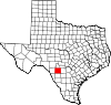
Fort Stockton is a city in and the county seat of Pecos County, Texas, United States. It is located on Interstate 10, future Interstate 14, U.S. Highways 67, 285, and 385, and the Santa Fe Railroad, 329 mi (529 km) northwest of San Antonio and 240 mi (390 km) southeast of El Paso. Its population was 8,466 at the 2020 census.
Fort Concho is a former United States Army installation and National Historic Landmark District located in San Angelo, Texas. It was established in November 1867 at the confluence of the North and South Concho Rivers, on the routes of the Butterfield Overland Mail Route and Goodnight–Loving Trail, and was an active military base for the next 22 years. Fort Concho was the principal base of the 4th Cavalry from 1867 to 1875 and then the "Buffalo Soldiers" of the 10th Cavalry from 1875 to 1882. The troops stationed at Fort Concho participated in Ranald S. Mackenzie's 1872 campaign, the Red River War in 1874, and the Victorio Campaign of 1879–1880.
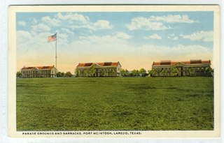
Fort McIntosh was a U.S. Army base in Laredo, Webb County, Texas, from 1849 to 1946.

Fort Davis National Historic Site is a United States National Historic Site located in the unincorporated community of Fort Davis, Jeff Davis County, Texas. Located within the Davis Mountains of West Texas, the historic site was established in 1961 to protect one of the best remaining examples of a United States Army fort in the southwestern United States.

Fort Duncan was a United States Army base, set up to protect the first U.S. settlement on the Rio Grande near the current town of Eagle Pass, Texas.

Fort Gibson is a historic military site next to the modern city of Fort Gibson, in Muskogee County Oklahoma. It guarded the American frontier in Indian Territory from 1824 to 1888. When it was constructed, the fort was farther west than any other military post in the United States. It formed part of the north–south chain of forts that was intended to maintain peace on the frontier of the American West and to protect the southwestern border of the Louisiana Purchase. The fort succeeded in its peacekeeping mission for more than 50 years, as no massacres or battles occurred there.

Fort Griffin, now a Texas state historic site as Fort Griffin State Historic Site, was a US Cavalry fort established 31 July 1867 by four companies of the Sixth Cavalry, U.S. Army under the command of Lt. Col. S. D. Sturgis, in the western part of North Texas, specifically northwestern Shackelford County, to give settlers protection from early Comanche and Kiowa raids. Originally called Camp Wilson after Henry Hamilton Wilson, a recently deceased lieutenant and son of Republican senator and later vice president, Henry Wilson, it was later named for Charles Griffin, a former Civil War Union general who had commanded, as de facto military governor, the Department of Texas during the early years of Reconstruction.

Fort Chadbourne was a fort established by the United States Army on October 28, 1852, in what is now Coke County, Texas, to protect the western frontier and the Butterfield Overland Mail route. It was named after Lt. T.L. Chadbourne, who was killed in the Battle of Resaca de la Palma. It was defended by Companies A and K of the 8th U.S. Infantry. During the early days of the American Civil War, the fort surrendered to the Confederates on February 28, 1861, even before the Confederate shelling of Fort Sumter, South Carolina, but was reoccupied by federal troops from 1865 to 1867.

Fort Yuma was a fort in California located in Imperial County, across the Colorado River from Yuma, Arizona. It was Established in 1848. It served as a stop on the Butterfield Overland Mail route from 1858 until 1861. The fort was retired from active military service on May 16, 1883, and transferred to the Department of the Interior. The Fort Yuma Indian School and the Saint Thomas Yuma Indian Mission now occupy the site. It is one of the "associated sites" listed as Yuma Crossing and Associated Sites on the National Register of Historic Places in the Yuma Crossing National Heritage Area. In addition, it is registered as California Historical Landmark #806.
Fort Richardson was a United States Army installation located in present-day Jacksboro, Texas. Named in honor of Union General Israel B. Richardson, who died in the Battle of Antietam during the American Civil War, it was active from 1867 to 1878. Today, the site, with a few surviving buildings, is called Fort Richardson State Park, Historic Site and Lost Creek Reservoir State Trailway. It was designated a National Historic Landmark in 1963 for its role in securing the state's northern frontier in the post-Civil War era.
The Forts of Texas include a number of historical and operational military installations. For over 200 years, various groups fought over access to or control over the region that is now Texas. Possession of the region was claimed and disputed by the European powers of Spain and France, and the continental countries of Mexico, the United States, the Republic of Texas, and the Confederate States of America. Ownership of specific lands was claimed and disputed by different ethnic groups, including numerous Native American tribes, Mexican residents, Anglo- and African-American settlers, and European immigrants. Access to and control of resources were claimed and disputed by various economic groups, including indigenous hunter/gatherers, farmers, herders, ranchers, colonists, settlers, buffalo hunters, traders, bandits, smugglers, pirates, and revolutionaries. Over the centuries, claims and disputes were enforced by Native American warriors, Spanish conquistadors, French cavaliers, Texas Rangers, local militias, and uniformed regular army regiments of Spain, Mexico, Texas, the United States, and the Confederacy.

The Fort McKavett State Historic Site is a former United States Army installation located in Menard County, Texas. The fort was first established in 1852 as part of a line of forts in Texas intended to protect migrants traveling to California. The fort was deemed unnecessary and abandoned in 1859 and was occupied by settlers. From 1861 to 1863, during the American Civil War, the fort became an outpost of Confederate forces on the Texas frontier until they left for other theaters of the war. When the US Army returned to Texas in the later 1860s, the fort was reoccupied and rebuilt, and became a base for the "Buffalo Soldier", or all-African American, 24th Infantry and 9th Cavalry Regiments.

Fort Phantom Hill, also called the Camp on the Clear Fork, is a former United States Army installation located in Jones County, Texas. The fort was established in 1851 as part of a line of forts in Texas to protect migrants passing through the state on their way to California. The US Army abandoned the fort in 1854 and it was shortly thereafter mostly destroyed by fire. In 1858, it became a station of the Butterfield-Overland Mail route until it moved out of Texas with the beginning of the American Civil War in 1861. During the war, the fort was occupied by Confederate frontier troops until the Confederacy's defeat and surrender. Following the US Army's return to Texas after the Civil War, Fort Phantom Hill was used as a subpost of the larger, newer Fort Griffin until 1875.
Fort Washita is the former United States military post and National Historic Landmark located in Durant, Oklahoma on SH 199. Established in 1842 by General Zachary Taylor to protect citizens of the Choctaw and Chickasaw Nations from the Plains Indians, it was later abandoned by Federal forces at the beginning of the American Civil War. Confederate troops held the post until the end of the war when they burned the remaining structures. It was never reoccupied by the United States military. After years in private hands the Oklahoma Historical Society bought the fort grounds in 1962 and restored the site. In 2017, the Chickasaw Nation purchased Fort Washita from the Oklahoma Historical Society and assumed responsibility for the site and its management. Today, Fort Washita is a tourist attraction and hosts several events throughout the year. In August 2023, the Fort Washita Historic Site was placed into federal trust with the U.S. government.
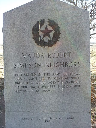
Robert Simpson Neighbors was an Indian agent and Texas state legislator. Known as a fair and determined protector of Indian interests as guaranteed by treaty, he was murdered by a white man named Cornet, whose brother-in-law had been defamed by Neighbors, accusing the brother-in-law a common horse thief, responsible for stealing horses from the reservation Indians. When Neighbors refused to recant the accusation in front of the two men, Cornet shot Neighbors with a shotgun. Cornet was murdered and Murphy acquitted as he did not pull the trigger. Cornet went on the run and was killed during his arrest.

Fort Belknap, located near Newcastle, Texas, was established in November 1851 by brevet Brigadier General William G. Belknap to protect the Texas frontier against raids by the Kiowa and Comanche. It was the northernmost fort in a line from the Rio Grande to the Red River. The fort functioned as a base of operations rather than as a fortified point, and it became the center of a substantial network of roads, including the Butterfield Overland Mail. The fort was designated a National Historic Landmark in 1960, in recognition of its key role in securing the Texas frontier in the 1850s and 1860s.
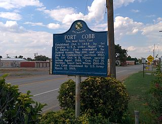
Fort Cobb was a United States Army post established in what is now Caddo County, Oklahoma in 1859 to protect relocated Native Americans from raids by the Comanche, Kiowa, and Cheyenne. The fort was abandoned by Maj. William H. Emory at the beginning of the Civil War, but then occupied by Confederate forces from 1861–1862. The post was eventually reoccupied by US forces starting in 1868. After establishing Fort Sill the US Army abandoned Fort Cobb. Today there is little left of the former military post.
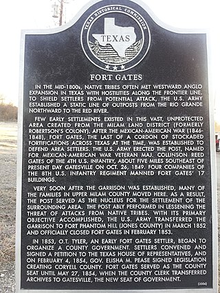
Fort Gates, was a United States Army fort established on October 26, 1849, as Camp Gates by Captain William Reading Montgomery and two companies of the Eighth United States Infantry. The fort was located on the north bank of the Leon River about five miles east of the site of present Gatesville, Texas. The installation was named for Brevet Major Collinson Reed Gates of New York, a noted officer in the Battle of Palo Alto and the Battle of Resaca de la Palma. The fort was established to protect settlers on the Texas frontier from Indians. The fort was garrisoned by companies D, I, F, and H of the Eighth United States Infantry. In April 1851, 256 enlisted men and forty-five officers were stationed at Fort Gates, the most reported in a single month.

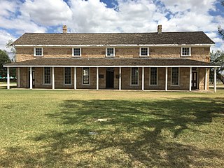
Fort Clark was a frontier fort located just off U.S. Route 90 near Brackettville, in Kinney County, Texas, United States. It later became the headquarters for the 2nd Cavalry Division. The Fort Clark Historic District was added to the National Register of Historic Places on December 6, 1979. The Commanding Officer's Quarters at Fort Clark were designated a Recorded Texas Historic Landmark in 1988. The Fort Clark Guardhouse became a Recorded Texas Historic Landmark in 1962. The Fort Clark Officers' Row Quarters were designated a Recorded Texas Historic Landmark in 1991.
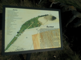
The Texas Forts Trail is a nonprofit organization chartered in 1999 which promotes heritage tourism, economic development, and historic preservation. It is one of 10 driving trail regions which make up the award-winning Texas Heritage Trails Program of the Texas Historical Commission. The driving trail is 650 miles (1,050 km) long.