Utopia, Texas

Last updated

Utopia, Texas
Nickname(s): 
"An Ideally, Perfect Place"
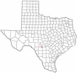
TXMap-doton-Utopia.PNG
Location of Utopia, Texas
Uvalde County Utopia.svg
Coordinates: 29°36′59″N99°31′36″W / 29.61639°N 99.52667°W / 29.61639; -99.52667
Country United States
State Texas
County Uvalde
Area
  Total3.0 sq mi (7.6 km2)
  Land3.0 sq mi (7.6 km2)
  Water0.0 sq mi (0.0 km2)
Elevation
[1]
1,362 ft (415 m)
Population
 (2010)
  Total227
  Density76/sq mi (30/km2)
Time zone UTC-6 (Central (CST))
  Summer (DST) UTC-5 (CDT)
ZIP code
78884
Area code 830
FIPS code 48-74576 [2]
GNIS feature ID1349137 [1]
Website www.utopiatexas.info

Utopia is a census-designated place (CDP) in Uvalde County, Texas, United States. The population was 227 at the 2010 census. [3]

Contents

History

Karl Burkli of Zürich, Switzerland, one of the early Swiss Socialists, had moved to Texas in 1855 to take part in an endeavor to found a utopian self-sustaining community named Utopia. However, the project didn't succeed and Burkli moved back to Zürich. He took part in the movement to end the rule of the liberal majority in Zürich. In 1868 he was elected to the council for the revision of the constitution of Zürich.

Others say citizens of another earlier settlement of Waresville called it Utopia after finding that the name "Montana, Texas," had already been taken. To this day the cemetery is named for Waresville. A planned utopian community nearby was cancelled after the failure of La Reunion near Dallas discouraged colonizers. The nearby city of Castroville was founded by French-Alsatian settlers.

Geography

Utopia is located at 29°36′59″N99°31′36″W / 29.61639°N 99.52667°W / 29.61639; -99.52667 (29.616402, -99.526623). [4]

According to the United States Census Bureau, the CDP has a total area of 3.0 square miles (7.6 km2), all land.

Climate

According to the Köppen Climate Classification system, Utopia has a humid subtropical climate, abbreviated "Cfa" on climate maps. [5]

Demographics

2000 Census

As of the census [2] of 2000, there were 241 people, 111 households, and 69 families residing in the CDP. The population density was 81.6 inhabitants per square mile (31.5/km2). There were 127 housing units at an average density of 43.0 per square mile (16.6/km2). The racial makeup of the CDP was 93.36% White, 0.41% Native American, 4.56% from other races, and 1.66% from two or more races. Hispanic or Latino of any race were 8.30% of the population.

There were 111 households, out of which 23.4% had children under the age of 18 living with them, 52.3% were married couples living together, 9.0% had a female householder with no husband present, and 37.8% were non-families. 35.1% of all households were made up of individuals, and 22.5% had someone living alone who was 65 years of age or older. The average household size was 2.17 and the average family size was 2.77.

In the CDP, the population was spread out, with 23.2% under the age of 18, 4.1% from 18 to 24, 21.6% from 25 to 44, 23.7% from 45 to 64, and 27.4% who were 65 years of age or older. The median age was 46 years. For every 100 females, there were 92.8 males. For every 100 females age 18 and over, there were 88.8 males.

The median income for a household in the CDP was $28,281, and the median income for a family was $35,893. Males had a median income of $25,714 versus $16,667 for females. The per capita income for the CDP was $18,608. About 15.5% of families and 19.6% of the population were below the poverty line, including 16.9% of those under the age of eighteen and 21.5% of those 65 or over.
Education

Utopia is served by the Utopia Independent School District which operates Utopia High School.

Seven Days in Utopia (2011) was filmed primarily in Utopia as well as at the Boot Ranch golf club just north of Fredericksburg, and featuring Academy Award winner Robert Duvall and Lucas Black. It is based on the book Golf's Sacred Journey: Seven Days at the Links of Utopia, Grand Rapids: Zondervan, 2009. ISBN   978-0-310-31885-9

American rapper Travis Scott, who is also from Texas, released his fourth studio album Utopia in 2023 and used the town to promote the album, placing billboards and totems which played a siren-like sound.

Related Research Articles

<span class="mw-page-title-main">Mountainaire, Arizona</span> CDP in Coconino County, Arizona

Mountainaire is a census-designated place (CDP) in Coconino County, Arizona, United States. The population was 1,119 at the 2010 census.

<span class="mw-page-title-main">Lost Hills, California</span> Census-designated place in California, United States

Lost Hills is a census-designated place (CDP) in Kern County, California, United States. Lost Hills is located 42 miles (68 km) west-northwest of Bakersfield, at an elevation of 305 feet (93 m). The population was 2,412 at the 2010 census, up from 1,938 at the 2000 census.

<span class="mw-page-title-main">West Modesto, California</span> Census-designated place in California, United States

West Modesto is a census-designated place (CDP) in Stanislaus County, California, United States. The population was 5,682 at the 2010 census, down from 6,096 at the 2000 census. It is part of the Modesto Metropolitan Statistical Area.

<span class="mw-page-title-main">Halfway, Maryland</span> CDP in Maryland, United States

Halfway is a census-designated place (CDP) in Washington County, Maryland, United States. The population was 11,896 at the 2020 census. It is named due to its location, which is halfway between Hagerstown and Williamsport. As a major suburb of Hagerstown, Halfway is part of the Hagerstown-Martinsburg, MD-WV, Metropolitan Statistical Area.

<span class="mw-page-title-main">Twin Lakes, New Mexico</span> CDP in New Mexico, United States

Twin Lakes is a census-designated place (CDP) in McKinley County, New Mexico, United States. The population was 1,069 at the 2000 census.

<span class="mw-page-title-main">Penn Township, Clearfield County, Pennsylvania</span> Township in Pennsylvania, United States

Penn Township is a township in Clearfield County, Pennsylvania, United States. The population was 1,203 at the 2020 census.

<span class="mw-page-title-main">Gloverville, South Carolina</span> Census-designated place in South Carolina, United States of America

Gloverville is a census-designated place (CDP) in Aiken County, South Carolina, United States. The population was 2,831 at the 2010 census. It is part of the Augusta, Georgia metropolitan area. Gloverville is located in historic Horse Creek Valley.

<span class="mw-page-title-main">Colonial Pine Hills, South Dakota</span> CDP in South Dakota, United States

Colonial Pine Hills is a census-designated place (CDP) and unincorporated community in Pennington County, South Dakota, United States. The population was 1,903 at the 2020 census.

<span class="mw-page-title-main">Cantu Addition, Texas</span> Census-designated place in Texas, United States

Cantu Addition is a census-designated place (CDP) in Brooks County, Texas, United States. Its population was 188 at the 2010 census.

<span class="mw-page-title-main">Bixby, Texas</span> CDP in Texas, United States

Bixby is a census-designated place (CDP) in Cameron County, Texas, United States. The population was 504 at the 2010 census. It is part of the Brownsville–Harlingen Metropolitan Statistical Area.

<span class="mw-page-title-main">Solis, Texas</span> Census-designated place in Texas, United States

Solis is a census-designated place (CDP) in Cameron County, Texas, United States. The population was 512 at the 2010 census. It is part of the Brownsville–Harlingen Metropolitan Statistical Area.

<span class="mw-page-title-main">Gardendale, Texas</span> Census-designated place in Texas, United States

Gardendale is an unincorporated area and census-designated place (CDP) in Ector County, Texas, United States. The population was 1,574 at the 2010 census, up from 1,197 at the 2000 census. It is part of the Odessa, Texas, Metropolitan Statistical Area.

<span class="mw-page-title-main">Morse, Texas</span> Census-designated place in Texas, United States

Morse is an unincorporated community and census-designated place (CDP) in Hansford County, Texas, United States. The population was 147 at the 2010 census, down from 172 at the 2000 census.

<span class="mw-page-title-main">Central Gardens, Texas</span> Census-designated place in Texas, United States

Central Gardens is an unincorporated community and census-designated place (CDP) in Jefferson County, Texas, United States. The population was 4,373 at the 2020 census. It is part of the Beaumont–Port Arthur metropolitan area.

<span class="mw-page-title-main">K-Bar Ranch, Texas</span> Census-designated place in Texas, United States

K-Bar Ranch is a census-designated place (CDP) in Jim Wells County, Texas, United States. The population was 358 at the 2010 census.

<span class="mw-page-title-main">Los Alvarez, Texas</span> CDP in Texas, United States

Los Alvarez is a census-designated place (CDP) in Starr County, Texas, United States. The population was 303 at the 2010 census, a decline from the figure of 1,434 tabulated in 2000.

<span class="mw-page-title-main">Elbert, Texas</span> CDP in Texas, United States

Elbert is a census-designated place (CDP) in Throckmorton County, Texas, United States. The population was 30 at the 2010 census.

<span class="mw-page-title-main">Knippa, Texas</span> Census-designated place in Texas, United States

Knippa is a census-designated place (CDP) in Uvalde County, Texas, United States. The population was 689 at the 2010 census.

Larga Vista is a former census-designated place (CDP) in Webb County, Texas, United States. The population was 742 at the 2000 census. Larga Vista lost its census-designated place status in 2010 because it became surrounded by Laredo. A CDP may not be located, either partially or entirely, within an incorporated place or another CDP. Today, Larga Vista is considered a Laredo neighborhood.

<span class="mw-page-title-main">Edison, Washington</span> CDP in Washington, United States

Edison is a census-designated place (CDP) in Skagit County, Washington, United States. The population was 133 at the 2010 census. It is included in the Mount Vernon–Anacortes, Washington Metropolitan Statistical Area.

References

Further reading

Valby, Karen (2010). Welcome to Utopia: Notes from a Small Town . New York: Spiegel & Grau. ISBN   978-0-385-52286-1.