
Palo Pinto County is a county located in the U.S. state of Texas. As of the 2020 census, its population was 28,409. The county seat is Palo Pinto. The county was created in 1856 and organized the following year.

Strawn is a city in Palo Pinto County, Texas, United States. The population was 540 at the 2020 census. Strawn, on State Highway 16 and 108, Farm to Market Road 2372, and the Missouri Pacific Railroad in southwestern Palo Pinto County, was one of several towns developed about 1880 when the Texas and Pacific Railway began service. The site, known earlier as North Fork for its location on Palo Pinto Creek, was laid out on the land of two early ranchers, Stephen Bethel Strawn and James N. Stuart. Stuart built the area's first house in 1875. A community to the west, Russell's Pocket, and one to the east, Davidsonville, were merged to form Strawn.

Mineral Wells is a city in Palo Pinto and Parker Counties in the U.S. state of Texas. The population was 14,820 at the 2020 census. The city is named for mineral wells in the area, which were highly popular in the early 1900s.

Hueco Tanks is an area of low mountains and historic site in El Paso County, Texas, in the United States. It is located in a high-altitude desert basin between the Franklin Mountains to the west and the Hueco Mountains to the east. Hueco is a Spanish word meaning hollows and refers to the many water-holding depressions in the boulders and rock faces throughout the region. Due to the unique concentration of historic artifacts, plants and wildlife, the site is under protection of Texas law; it is a crime to remove, alter, or destroy them.

Lost Maples State Natural Area is a 2,906-acre (1,176 ha) area of hills and canyons on the upper Sabinal River in the Edwards Plateau Region of Texas. It is designated a Natural Area, rather than a State Park, which means the primary focus is the maintenance and protection of the property's natural state. Accordingly, access and recreational activities may be restricted if the Texas Parks & Wildlife Department (TPWD) deems such action necessary to protect the environment.

Possum Kingdom State Park is a state park in Palo Pinto County, Texas, USA, that was built in the 1940s by Civilian Conservation Corps Company 2888 and opened to the public in 1950. It covers approximately 1,530 acres (620 ha), and lies in the Palo Pinto Mountains and Brazos River Valley of Texas. The park borders the large Possum Kingdom Lake, a 20,000-acre (8,100 ha) lake known for its clear blue waters. Possum Kingdom winds for 65 miles (105 km) down the Brazos River, and has more than 300 miles (480 km) of shoreline. A privately owned store and marina in the park cater to boaters and campers.
Wichita Mountains Wildlife Refuge, located in southwestern Oklahoma near Lawton, has protected unique wildlife habitats since 1901 and is the oldest managed wildlife facility in the United States Fish and Wildlife Service system. The refuge's location in the geologically unique Wichita Mountains and its areas of undisturbed mixed grass prairie make it an important conservation area. The Wichita Mountains are approximately 500 million years old. Measuring about 59,020 acres (238.8 km2), the refuge hosts a great diversity of species: 806 plant species, 240 species of birds, 36 fish, and 64 reptiles and amphibians are present.
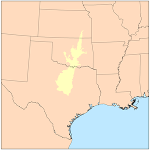
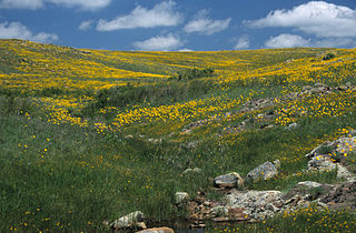
The term Cross Timbers, also known as Ecoregion 29, Central Oklahoma/Texas Plains, is used to describe a strip of land in the United States that runs from southeastern Kansas across Central Oklahoma to Central Texas. Made up of a mix of prairie, savanna, and woodland, it forms part of the boundary between the more heavily forested eastern country and the almost treeless Great Plains, and also marks the western habitat limit of many mammals and insects.

Inks Lake State Park is a state park located in Burnet County, Texas, United States, next to Inks Lake on the Colorado River. The landscape of the park is hilly, with many cedar, live oak, prickly pear cacti, and yuccas. The ground is rocky, mainly consisting of gneiss rock.

The Columbus and Franklin County Metro Parks are a group of 20 metropolitan parks in and around Columbus, Ohio. They are officially organized into the Columbus and Franklin County Metropolitan Park District. The Metro Parks system was organized in 1945 under Ohio Revised Code Section 1545 as a separate political division of the state of Ohio. The Metro Parks are overseen by a Board of Park Commissioners consisting of three citizens appointed to three-year terms without compensation by the Judge of the Probate Court of Franklin County, Ohio. The Board in turn appoints an Executive Director responsible for operations and management of the parks.

Cleburne State Park is a 528-acre (2.14 km2) Texas state park in Johnson County, Texas operated by the Texas Parks and Wildlife Department. The park includes the 116-acre (0.47 km2), spring-fed Cedar Lake that was created by construction of an earthen dam by the Civilian Conservation Corps.

McKinney Falls State Park is a state park in Austin, Texas, United States at the confluence of Onion Creek and Williamson Creek. It is administered by the Texas Parks and Wildlife Department. The park opened on April 15, 1976 and is named after Thomas F. McKinney, a businessman, race horse breeder and rancher, who owned and lived on the land in the mid-to-late 19th century. The park is part of the El Camino Real de los Tejas National Historic Trail.
The term Palo Pinto Mountains properly refers to a specific cuesta-like range of hills in western Palo Pinto County, Texas. The name Palo Pinto roughly translates to "painted stick" in reference to the juniper trees of the area. Isolated, rugged, and scenic, the ridge extends some 15 miles, from near the intersection of Texas State Highway 16 and Farm to Market Road 207 in the southwest, to Crawford Mountain just south of the Fortune Bend on the Brazos River in the northeast.

Big Bend Ranch State Park is a 311,000-acre (126,000 ha) state park located on the Rio Grande in Brewster and Presidio counties, Texas. It is the largest state park in Texas. The closest major town is Presidio, Texas. The state park's head office is located in Lajitas, Texas at the Barton Warnock Visitor Center. It includes Colorado Canyon.

John Redmond Reservoir is a reservoir on the Neosho River in eastern Kansas. Built and managed by the U.S. Army Corps of Engineers, it is used for flood control, recreation, water supply, and wildlife management. It borders the Flint Hills National Wildlife Refuge to the northwest.
Eisenhower State Park is a state park located in Grayson County, Texas, northwest of Denison, Texas on the shores of Lake Texoma. The park is 423.1 acres (171 ha).
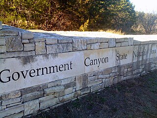
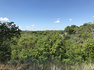
First opened to the public in October, 2005, Government Canyon State Natural Area (GCSNA) preserves 12,244 acres of rugged hills and canyons typical of the Texas Hill Country. It is designated a Natural Area, rather than a State Park, and therefore the primary focus is maintenance and protection of the property's natural state. Accordingly, access and recreational activities may be restricted if the Texas Parks & Wildlife Department (TPWD) deems such action necessary to protect the environment.

Bonham State Park is a 261-acre (1.06 km2) state park located in Bonham, Texas. It includes a 65-acre (260,000 m2) lake, rolling prairies, and woodlands.

South Llano River State Park is a 2600 acre state park located along the South Llano River in Kimble County, Texas. The park opened to the public in 1990 and is managed by the Texas Parks and Wildlife Department.
The Fort Worth Nature Center & Refuge is a nature center located between Lakeside and Lake Worth, Texas within Fort Worth, Texas, United States city limits. It consists of prairies, forests, and wetlands. The nature center offers a glimpse of what the Dallas–Fort Worth metroplex looked like before settlement. The center covers 3,621 acres (1,465 ha) and includes over 20 miles (32 km) of hiking trails. It is one of the largest city-owned nature centers in the United States.

