External links

| | This article related to a protected area in Texas is a stub. You can help Wikipedia by expanding it. |
| | This United States trail or long-distance path–related article is a stub. You can help Wikipedia by expanding it. |
The State of Texas (United States) has designated numerous trail systems and nature preserves as part of the "Great Texas Wildlife Trails." These are broken into four major trail systems.
| | This article related to a protected area in Texas is a stub. You can help Wikipedia by expanding it. |
| | This United States trail or long-distance path–related article is a stub. You can help Wikipedia by expanding it. |

The Great Plains, sometimes simply "the Plains", is a broad expanse of flatland in North America. It is located west of the Mississippi River and east of the Rocky Mountains, much of it covered in prairie, steppe and grassland. It is the southern and main part of the Interior Plains, which also include the tallgrass prairie between the Great Lakes and Appalachian Plateau, and the Taiga Plains and Boreal Plains ecozones in Northern Canada. The term Western Plains is used to describe the ecoregion of the Great Plains, or alternatively the western portion of the Great Plains.

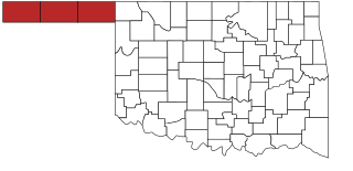
Texas County is a county located in the panhandle of the U.S. state of Oklahoma. Its county seat is Guymon. As of the 2010 census, the population was 20,640. It is the second largest county in Oklahoma, based on land area, and is named for Texas, the state that adjoins the county to its south. Texas County comprises the Guymon, OK Micropolitan Statistical Area. The county economy is largely based on farming and cattle production. It is one of the top-producing counties in the U.S. for wheat, cattle, and hogs. It also lies within the noted Hugoton-Panhandle natural gas field.
Guymon is a city and county seat of Texas County, in the panhandle of Oklahoma, United States. As of the 2020 census, the city population was 12,965, an increase of 13.3% from 11,442 in 2010, and represents more than half of the population of the county. Cattle feedlots, corporate pork farms, and natural gas production dominate its economy, with wind energy production and transmission recently diversifying landowners' farms.

Palo Duro Canyon is a canyon system of the Caprock Escarpment located in the Texas Panhandle near the cities of Amarillo and Canyon. As the second-largest canyon in the United States, it is roughly 120 mi (190 km) long and has an average width of 6 mi (9.7 km), but reaches a width of 20 mi (32 km) at places. Its depth is around 820 ft (250 m), but in some locations, it increases to 1,000 ft (300 m). Palo Duro Canyon has been named "The Grand Canyon of Texas" both for its size and for its dramatic geological features, including the multicolored layers of rock and steep mesa walls, which are similar to those in the Grand Canyon. It is part of Palo Duro Canyon State Park.

The Texas Panhandle is a region of the U.S. state of Texas consisting of the northernmost 26 counties in the state. The panhandle is a rectangular area bordered by New Mexico to the west and Oklahoma to the north and east. It is adjacent to the Oklahoma Panhandle. The Handbook of Texas defines the southern border of Swisher County as the southern boundary of the Texas Panhandle region.
Charles Goodnight, also known as Charlie Goodnight, was an American rancher in the American West, perhaps the best known rancher in Texas. He is sometimes known as the "father of the Texas Panhandle." Essayist and historian J. Frank Dobie said that Goodnight "approached greatness more nearly than any other cowman of history." In 1955, he was inducted into the Hall of Great Westerners of the National Cowboy & Western Heritage Museum.
The Oklahoma Panhandle is the extreme northwestern region of the U.S. state of Oklahoma, consisting of Cimarron County, Texas County and Beaver County, from west to east. As with other salients in the United States, its name comes from the similarity of its shape to the handle of a pan.

The Idaho Panhandle National Forests are a jointly administered set of three national forests located mostly in the U.S. state of Idaho. In 1973, major portions of the Kaniksu, Coeur d'Alene, and St. Joe National Forests were combined to be administratively managed as the Idaho Panhandle National Forests (IPNF). The IPNF consists of more than 2.5 million acres (10,000 km2) of public lands in the panhandle of north Idaho, with small areas extending into eastern Washington (4.7%) and western Montana (1.2%). The northernmost portion of the IPNF share a boundary with Canada. The Forest Supervisor's office is located in Coeur d'Alene, Idaho with district office's in Bonners Ferry, Sandpoint, Priest River, Fernan and Smelterville, and St. Maries and Avery.
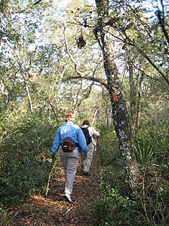
The Florida Trail is one of eleven National Scenic Trails in the United States. It currently runs 1,000 miles (1,600 km), with 300 miles (480 km) planned, from Big Cypress National Preserve to Fort Pickens at Gulf Islands National Seashore, Pensacola Beach. Also known as the Florida National Scenic Trail, the Florida Trail provides permanent non-motorized recreation opportunity for hiking and other compatible activities and is within an hour of most Floridians. The Florida National Scenic Trail is designated as a National Scenic Trail by the National Trails System Act of 1968.
Great Florida Birding and Wildlife Trail (GFBWT) is a 2,000 mile (3200 km) long collection of more than 500 locations in the U.S. state of Florida where the state's bird habitats are protected. The trail promotes birdwatching, environmental education and ecotourism. The GFBWT is a program of the Florida Fish and Wildlife Conservation Commission, supported in part by the Florida Department of Transportation and the Wildlife Foundation of Florida. It is modeled after the successful Great Texas Coastal Birding Trail. Trail sites area identifiable by prominent road signs bearing the Swallow-tailed kite logo.
Eisenhower State Park is a state park located in Grayson County, Texas, northwest of Denison, Texas on the shores of Lake Texoma. The park is 423.1 acres (171 ha).

The Lower Rio Grande Valley National Wildlife Refuge is a 90,788-acre (367.41 km2) National Wildlife Refuge located in the Lower Rio Grande Valley region of southern Texas.

The Great Texas Coastal Birding Trail is a state-designated system of trails, bird sanctuaries, and nature preserves along the entire length of the Texas Gulf Coast in the United States. As the state of Texas hosts more bird species than any other state in the U.S. the trail system offers some of the most unusual opportunities for bird-watching in the world. The "trail" is actually 43 separate hiking and driving trails that include 308 birding sites. The sites themselves feature a variety of viewing opportunities with boardwalks, observation decks, and other amenities. The trails boast more than 450 bird species. The trail system is managed by the Texas Parks and Wildlife Department as part of the Great Texas Wildlife Trails which also include the Heart of Texas Wildlife Trail, the Panhandle Plains Wildlife Trail, and the Prairies and Pineywoods Wildlife Trail.
The Heart of Texas Wildlife Trail is a state-designated system of trails and wildlife sanctuaries in Central Texas in the United States. It is one of the four major wildlife trail systems designated by the State of Texas.
The Panhandle Plains Wildlife Trail is a state-designated system of trails and wildlife sanctuaries in the Texas Panhandle in the United States. It is one of the four major wildlife trail systems designated by the State of Texas.
The Prairies and Pineywoods Wildlife Trail is a state-designated system of trails and wildlife sanctuaries in the Texas Panhandle in the United States. It is one of the four major wildlife trail systems designated by the State of Texas.

Pine Gully Park is a 52-acre (21 ha) park located in Seabrook, Texas in the United States, near Houston. It is located on the shore of Galveston Bay. The park belongs to the Seabrook Trail System and includes undeveloped and restored woodlands, salt marshes and several species of wildlife.
State wildlife trails in the United States are state-sponsored systems of hiking and driving trails developed for the benefit of birdwatching and wildlife enthusiasts. They have been created and maintained by state governments or other state-level entities, both to promote ecology and to promote tourism. The term "trail" used in the names of most of these systems is, in general, a misnomer as that these trail networks are not single routes and are connected by motorways.

Blanco State Park is a 104.6-acre (42.3 ha) park, along a mile of the Blanco River, on the southern edge of Blanco, Texas. It features camping, picnicking, screened shelters, swimming, tubing, nature trails, and a wildlife viewing station. The park is hilly with mostly cedar, and pecan trees. Among the animals seen at the park are nutria, mallards, raccoon, armadillo and squirrel.

Meridian State Park is a state park in Bosque County, Texas, United States. The park is 505 acres (204 ha).