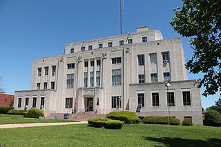
Bowie County is a county in the U.S. state of Texas. Its legal county seat is Boston, though its courthouse is located in New Boston. As of the 2020 census, the population was 92,893. Bowie County is part of the Texarkana metropolitan statistical area. The county is named for James Bowie, the legendary knife fighter who died at the Battle of the Alamo.
Miller County is a county located in the southwestern corner of the U.S. state of Arkansas. As of the 2020 census, the population was 42,600. The county seat is Texarkana.

Fouke is a city in Miller County, Arkansas, United States. It is part of the Texarkana, Texas - Texarkana, Arkansas Metropolitan Statistical Area. The population was 808 at the 2020 census.

Texarkana is a city in the U.S. state of Arkansas and the county seat of Miller County, on the southwest border of the state. As of the 2020 census, it had a population of 29,387. It is the twin city of Texarkana, Texas, located just across the state line. The city was founded at a railroad intersection on December 8, 1873, and was incorporated in Arkansas on August 10, 1880. Texarkana and its Texas counterpart are the principal cities of the Texarkana metropolitan area, which in 2021 was ranked 289th in the United States with a population of 147,174, according to the United States Census Bureau.

Nash is a city in Bowie County, Texas, United States, and a suburb of Texarkana. It is part of the Texarkana metropolitan area. The population was 2,960 at the 2010 census, up from 2,169 at the 2000 census. In 2020, its population was 3,814, representing continued population growth as a suburban community.

Texarkana is a city in Bowie County, Texas, United States, in the Ark-La-Tex region. Located approximately 180 miles (290 km) from Dallas, Texarkana is a twin city with neighboring Texarkana, Arkansas. The Texas city's population was 36,193 at the 2020 census.

Bowie is a town in Montague County, Texas, United States. The population was 5,448 at the 2020 census.

The Ark-La-Tex is a socio-economic tri-state region where the Southern U.S. states of Arkansas, Louisiana, and Texas join together. The region contains portions of Northwest Louisiana, Northeast Texas, and South Arkansas as well as the extreme southeastern tip of Oklahoma, in McCurtain County, partly centered upon the Red River, which flows along the Texas–Oklahoma state line into Southwestern Arkansas and Northwest Louisiana.

The Trinity River is a 710-mile (1,140 km) river, the longest with a watershed entirely within the U.S. state of Texas. It rises in extreme northern Texas, a few miles south of the Red River. The headwaters are separated by the high bluffs on the southern side of the Red River.

Northeast Texas is a cultural and geographic region in the northeast corner of the U.S. state of Texas. Geographically centered on two metropolitan areas strung along Interstate 20—Tyler in the west and Longview/Marshall to the east, the areas of Greenville, Mount Pleasant, Sulphur Springs, Paris, and Texarkana in the north primarily along Interstate 30, and Jacksonville and Palestine to the south are also major cities within the region. Most of Northeast Texas is included in the interstate region of the Ark-La-Tex.
Boston is an unincorporated community in, and the county seat of, Bowie County, Texas, United States. According to the Handbook of Texas, the community had a population of 200 in 2000. It is part of the Texarkana metropolitan area.

The Texarkana metropolitan statistical area (MSA), as defined by the United States Office of Management and Budget, is a two-county region anchored by the twin cities of Texarkana, Texas and Texarkana, Arkansas, and encompassing surrounding communities in Bowie County, Texas, and Miller County, Arkansas. As of the 2016 census, the MSA had a population of 150,098. Texarkana is a subset of the broader Ark-La-Tex region.

Wright Patman Lake is a reservoir in northeast Texas in the United States. The lake is a U.S. Army Corps of Engineers reservoir formed on the Sulphur River in Bowie and Cass counties by Wright Patman Dam. The reservoir provides flood control and water conservation for the communities downstream from the dam. The lake is also a popular recreational destination. The Bowie County side of the lake is part of the Texarkana metropolitan area.

Johnson Creek is a 25-mile (40 km) tributary of the Willamette River in the Portland metropolitan area of the U.S. state of Oregon. Part of the drainage basin of the Columbia River, its catchment consists of 54 square miles (140 km2) of mostly urban land occupied by about 180,000 people as of 2012. Passing through the cities of Gresham, Portland, and Milwaukie, the creek flows generally west from the foothills of the Cascade Range through sediments deposited by glacial floods on a substrate of basalt. Though polluted, it is free-flowing along its main stem and provides habitat for salmon and other migrating fish.

Antonio Maceo Smith was a civil rights leader in Dallas, Texas, whose years of activism with the National Association for the Advancement of Colored People (NAACP) and other civil rights and community groups led Texans to dub him "Mr. Civil Rights" and "Mr. Organization".
Leach Creek is a tributary of Leggetts Creek in Lackawanna County, Pennsylvania, in the United States. It is approximately 1.9 miles (3.1 km) long and flows through Scranton. The watershed of the creek has an area of 2.55 square miles (6.6 km2). The creek loses substantial amounts of water to underground mine pools. The creek is in the Coal Region and has been channelized and/or culvertized in some reaches. It flows alongside Pennsylvania Route 307 for a substantial part of its length. The creek has a riparian buffer in its upper and middle reaches, but various invasive plants grow along its banks in its lower reaches.
Spring Creek is a stream in Collin and Dallas counties, in the United States.Spring Creek is a 16.5-mile-long tributary of Rowlett Creek located in southern Collin County, Texas. It plays a significant role in the region's geography, history, and ecology.
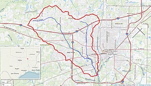
Cowhorn Creek is a creek in Bowie County, Texas. The creek rises in northeastern Texarkana and flows south, under several major highways including U.S. Route 82 and U.S. Route 67 before meeting Wagner Creek to the south of the city.
Swampoodle Creek is a creek in Bowie County, Texas. The creek rises in northern Texarkana and flows south, under several major highways including U.S. Route 82 and U.S. Route 67 before meeting Days Creek, alongside Nix Creek near the Arkansas border.
Nix Creek is a creek in the Texarkana metropolitan area. The creek is mainly situated in Texarkana, Arkansas, but briefly crosses the border into Texarkana, Texas where it meets Days Creek alongside Swampoodle Creek. The creek passes under U.S. Route 82.