Ellis County, Texas

Last updated

Ellis County
Ellis County Courthouse (1 of 1).jpg
The Ellis County Courthouse in Waxahachie
Map of Texas highlighting Ellis County.svg
Location within the U.S. state of Texas
Texas in United States.svg
Texas's location within the U.S.
Coordinates: 32°21′N96°47′W / 32.35°N 96.79°W / 32.35; -96.79
CountryFlag of the United States.svg United States
StateFlag of Texas.svg  Texas
Founded1850
Named for Richard Ellis
Seat Waxahachie
Largest cityWaxahachie
Area
  Total952 sq mi (2,470 km2)
  Land936 sq mi (2,420 km2)
  Water16 sq mi (40 km2)  1.7%
Population
 (2020)
  Total192,455 Increase2.svg
  Density200/sq mi (80/km2)
Demonym Ellisite
Time zone UTC−6 (Central)
  Summer (DST) UTC−5 (CDT)
Congressional district 6th
Website www.co.ellis.tx.us
Across from the courthouse is the Ellis County Museum. Waxahachie masonic lodge 2013.jpg
Across from the courthouse is the Ellis County Museum.

Ellis County is a county located in the U.S. state of Texas. As of 2020, its population was estimated to be 192,455. [1] The county seat is Waxahachie. [2] The county was founded in 1849 and organized the next year. [3] It is named for Richard Ellis, [4] president of the convention that produced the Texas Declaration of Independence. Ellis County is included in the DallasFort WorthArlington metropolitan statistical area.

Contents

Geography

According to the U.S. Census Bureau, the county has a total area of 952 square miles (2,470 km2), of which 935 square miles (2,420 km2) are land and 16 square miles (41 km2) (1.7%) are covered by water. [5]

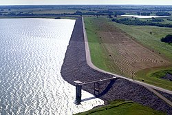
Lake Waxahachie is located about five miles south of Waxahachie in Ellis County, Texas. Owned and operated by Ellis County Water Control and Improvement District Number One on behalf of the city of Waxahachie, the lake was formed by impounding the Waxahachie Creek in 1956. The water covers about 650 acres and has a maximum depth around 50. [6] [7] The former community of South Prong was located beside the creek before the lake was created. [8] There has been a country club and a two-acre public park with boat ramp since the lake was completed. [9] The lake is a recreational resource for the entire county.

Major highways

Adjacent counties

Communities

Bardwell Dam and Lake in Ellis County near the town of Ennis USACE Bardwell Dam and Lake.jpg
Bardwell Dam and Lake in Ellis County near the town of Ennis
Ellis County Courts building Ellis County, TX Courts building IMG 5610.JPG
Ellis County Courts building

Cities (multiple counties)

Cities

Towns

Census-designated place

Unincorporated communities

Demographics

Historical population
CensusPop.Note
1850 989
1860 5,246430.4%
1870 7,51443.2%
1880 21,294183.4%
1890 31,77449.2%
1900 50,05957.5%
1910 53,6297.1%
1920 55,7003.9%
1930 53,936−3.2%
1940 47,733−11.5%
1950 45,645−4.4%
1960 43,395−4.9%
1970 46,6387.5%
1980 59,74328.1%
1990 85,16742.6%
2000 111,36030.8%
2010 149,61034.3%
2020 192,45528.6%
2022 (est.)212,18210.3%
U.S. Decennial Census [10]
1850–2010 [11] 2020 [12]
Ellis County, Texas - Demographic Profile
(NH = Non-Hispanic)
Race / EthnicityPop 2010 [13] Pop 2020 [12] % 2010% 2020
White alone (NH)97,987106,49565.49%55.34%
Black or African American alone (NH)13,16123,7388.80%12.33%
Native American or Alaska Native alone (NH)5657100.38%0.37%
Asian alone (NH)8111,5250.65%0.79%
Pacific Islander alone (NH)872020.06%0.10%
Some Other Race alone (NH)1557900.10%0.41%
Mixed Race/Multi-Racial (NH)1,6836,9631.12%3.62%
Hispanic or Latino (any race)35,16152,03223.50%27.04%
Total149,610192,455100.00%100.00%

Note: the US Census treats Hispanic/Latino as an ethnic category. This table excludes Latinos from the racial categories and assigns them to a separate category. Hispanics/Latinos can be of any race.

According to the census [14] of 2000, 111,360 people, 37,020 households, and 29,653 families resided in the county. The population density was 118 people per square mile (46 people/km2). The 39,071 housing units averaged 42 units per square mile (16/km2). The racial makeup of the county was 80.63% White, 8.64% African American, 0.59% Native American, 0.35% Asian, 7.92% from other races, and 1.86% from two or more races. About 18.42% of the population was Hispanic or Latinos of any race. By 2020, its population increased to 192,455. [12] The racial makeup in 2020 was 55.34% non-Hispanic white, 12.33% African American, 0.37% Native American, 0.79% Asian American, 0.41% some other race, 3.62% multiracial, and 27.04% Hispanic or Latino of any race.

A Williams Institute analysis of 2010 census data found about 3.2 same-sex couples per 1,000 households were in the county. [15]

Politics

Ellis is a staunchly Republican county in presidential elections. The last Democratic presidential candidate to carry the county was Jimmy Carter in 1976, and since 2000, Republican presidential candidates have won with more than 66% of the vote.

United States presidential election results for Ellis County, Texas [16]
Year Republican Democratic Third party
No.%No.%No.%
2020 56,71766.19%27,56532.17%1,4061.64%
2016 44,94170.10%16,25325.35%2,9164.55%
2012 39,57472.94%13,88125.59%7991.47%
2008 38,07870.71%15,33328.47%4420.82%
2004 34,60274.50%11,64025.06%2020.43%
2000 26,09169.94%10,62928.49%5871.57%
1996 16,04653.91%10,83236.39%2,8889.70%
1992 13,56440.50%9,53728.47%10,39431.03%
1988 16,42259.18%11,16940.25%1580.57%
1984 16,87367.56%8,02932.15%720.29%
1980 10,04651.31%9,21947.08%3151.61%
1976 6,99641.02%9,99158.58%680.40%
1972 8,77969.53%3,83930.41%80.06%
1968 3,79431.44%5,43145.01%2,84223.55%
1964 2,77927.62%7,27872.33%50.05%
1960 3,66638.42%5,84161.21%360.38%
1956 3,58540.65%5,21159.08%240.27%
1952 4,18339.91%6,27559.86%240.23%
1948 1,05513.76%5,79275.56%81810.67%
1944 6668.02%7,06585.08%5736.90%
1940 6928.07%7,88191.87%50.06%
1936 3195.34%5,64494.46%120.20%
1932 5276.93%7,03392.49%440.58%
1928 3,56944.72%4,39955.12%130.16%
1924 1,22013.50%7,67884.93%1421.57%
1920 81913.98%4,08169.68%95716.34%
1916 3246.32%4,71892.02%851.66%
1912 2937.42%3,48388.24%1714.33%

Law enforcement

The Ellis County Sheriff's Office provides law enforcement services to the county. The current sheriff is Brad Norman. The agency also operates the Ellis County Jail in Waxahachie. [17]

Media

Ellis County is part of the Dallas/Fort Worth television media market in North Texas. Stations in the market are KDFW-TV, KXAS-TV, WFAA-TV, KTVT-TV, KERA-TV, KTXA-TV, KDFI-TV, KDAF-TV, KFWD-TV, and KDTX-TV.

The county is home to one local radio station KBEC 1390 AM and 99.1 FM. The station has been in continuous operation since 1955 and is the oldest Family owned radio station in Texas. A weekly newspaper, the Ellis County Press, is based in Ferris and published Thursdays. The Waxahachie Daily Light and Waxahachie Sun are published biweekly; other weekly newspapers are The Ennis News and Midlothian Mirror.

Education

School districts include: [18]

It is in the service area of Navarro College. [19]

Notable people

See also

Related Research Articles

<span class="mw-page-title-main">Wise County, Texas</span> County in Texas, United States

Wise County is a county in the U.S. state of Texas. As of the 2020 census, its population was 68,632. Its county seat is Decatur. Wise County is part of the Dallas–Fort Worth–Arlington metropolitan statistical area. Its Wise Eyes crime-watch program, eventually adopted by mostly rural counties in several states, was started in 1993 by then-Sheriff Phil Ryan.

<span class="mw-page-title-main">Tarrant County, Texas</span> County in Texas, United States

Tarrant County is located in the U.S. state of Texas. As of 2020, it had a population of 2,110,640. It is Texas' third-most populous county and the 15th-most populous in the United States. Its county seat is Fort Worth. Tarrant County, one of 26 counties created out of the Peters Colony, was established in 1849 and organized the next year. It is named after Edward H. Tarrant, a slaveowner, lawyer, politician, and militia leader responsible for fighting and forcing native groups out of the area.

<span class="mw-page-title-main">Navarro County, Texas</span> County in Texas, United States

Navarro County is a county in the U.S. state of Texas. As of the 2020 census, the population was 52,624. Its county seat is Corsicana. The county is named for José Antonio Navarro, a Tejano leader in the Texas Revolution who signed the Texas Declaration of Independence.

<span class="mw-page-title-main">Johnson County, Texas</span> County in Texas, United States

Johnson County is a county located in the U.S. state of Texas. As of the 2020 census, its population was 179,927. Its county seat is Cleburne. Johnson County is named for Colonel Middleton Tate Johnson Sr., a Texas Ranger, politician and soldier in the Mexican-American War and the American Civil War. Johnson County is included in the Dallas–Fort Worth–Arlington metropolitan statistical area.

<span class="mw-page-title-main">Henderson County, Texas</span> County in Texas, United States

Henderson County is a county in the U.S. state of Texas. As of the 2020 census, its population was 82,150. The county seat is Athens. The county is named in honor of James Pinckney Henderson, the first attorney general of the Republic of Texas, and secretary of state for the republic. He later served as the first governor of Texas. Henderson County was established in 1846, the year after Texas gained statehood. Its first town was Buffalo, laid out in 1847. Henderson County comprises the Athens micropolitan statistical area, which is also included in the Dallas-Fort Worth combined statistical area.

<span class="mw-page-title-main">Denton County, Texas</span> County in Texas, United States

Denton County is located in the U.S. state of Texas. As of the 2020 census, its population was 906,422, making it the seventh-most populous county in Texas. The county seat is Denton. The county, which was named for John B. Denton, was established in 1846. Denton County constitutes part of the Dallas–Fort Worth metroplex. In 2007, it was one of the fastest-growing counties in the United States.

<span class="mw-page-title-main">Dallas County, Texas</span> County in Texas, United States

Dallas County is the second-most populous county in the U.S. state of Texas. As of the 2020 U.S. census, the population was 2,613,539, making it the ninth-most populous county in the country. Dallas County is included in the Dallas-Arlington-Fort Worth metropolitan statistical area—colloquially referred to as the Dallas–Fort Worth metroplex. Municipal expansion within Dallas County has blurred the geographic lines between cities and between neighboring counties.

<span class="mw-page-title-main">Ennis, Texas</span> City in Texas, United States

Ennis is a city in eastern Ellis County, Texas, United States. The population is 20,159 according to the 2020 census, with an estimated population of 21,210 in 2021. Ennis is home to the annual National Polka Festival.

<span class="mw-page-title-main">Italy, Texas</span> Town in Texas, United States

Italy is a town in Ellis County, Texas, United States. Its population was 1,926 in 2020. The community was named after Italy by a settler who had visited the European country.

<span class="mw-page-title-main">Maypearl, Texas</span> City in Texas, United States

Maypearl is a city in Ellis County, Texas, United States. Its population was 939 in 2020.

<span class="mw-page-title-main">Midlothian, Texas</span> City in Texas, United States

Midlothian is a city in northwest Ellis County, Texas, United States. The city is 25 miles (40 km) southwest of Dallas. It is the hub for the cement industry in North Texas, as it is the home to three separate cement production facilities, as well as a steel mill. The population of Midlothian grew by 121% between 2000 and 2010, to a population of 18,037.

<span class="mw-page-title-main">Palmer, Texas</span> Town in Texas, United States

Palmer is a town in Ellis County, Texas, United States. It is part of the Dallas–Fort Worth metroplex. Its population was 2,393 in 2020.

<span class="mw-page-title-main">Red Oak, Texas</span> City in Texas, United States

Red Oak is a city in Ellis County, Texas, United States. It is part of the Dallas–Fort Worth metroplex. The population was 10,769 at the 2010 census, up from 4,301 at the 2000 census. The North Central Texas Council of Governments projects that number to grow to 63,329 by the year 2030, as it is on the verge of explosive suburban growth. Red Oak was one of the exterior locations for filming True Stories, directed by David Byrne of Talking Heads and released in 1986.

<span class="mw-page-title-main">Waxahachie, Texas</span> City in Texas, United States

Waxahachie is the county seat of Ellis County, Texas, United States. Its population was 41,140 in 2020.

<span class="mw-page-title-main">Ferris, Texas</span> City in Texas, United States

Ferris is a city in Dallas and Ellis counties in the U.S. state of Texas. It is 20 miles (32 km) south of downtown Dallas. The population was 2,788 in 2020.

<span class="mw-page-title-main">Grand Prairie, Texas</span> City in Texas

Grand Prairie is a city in Dallas, Tarrant, and Ellis counties of Texas, United States. It is part of the Mid-Cities region in the Dallas–Fort Worth metroplex. It had a population of 175,396 according to the 2010 census, making it the fifteenth most populous city in the state. Remaining the 15th-most populous city in Texas, the 2020 census reported a population of 196,100.

<span class="mw-page-title-main">Ovilla, Texas</span> City in Texas, United States

Ovilla is a city in Dallas and Ellis Counties in the U.S. state of Texas. The population was 4,304 at the 2020 census.

<span class="mw-page-title-main">Mansfield, Texas</span> City in Texas, United States

Mansfield is a suburban city in the U.S. state of Texas, and is part of the Dallas–Fort Worth metroplex area. The city is located mostly in Tarrant County, with small parts in Ellis and Johnson counties. Its location is approximately 30 miles from Dallas and 20 miles from Fort Worth, and is adjacent to Arlington. As of the 2010 census, the population was 56,368, up from 28,031 in 2000. The estimated population in 2020 is 73,550.

<span class="mw-page-title-main">Venus, Texas</span> Town in Texas, United States

Venus is a town in Johnson and Ellis counties in the U.S. state of Texas. The population was 4,361 in 2020.

<span class="mw-page-title-main">Bristol, Texas</span> Census-designated place in Texas, United States

Bristol is a census-designated place in Ellis County, Texas, United States. The population was 668 at the 2010 census.

References

  1. "Ellis County, Texas". United States Census Bureau . Retrieved January 30, 2022.
  2. "Find a County". National Association of Counties. Archived from the original on May 31, 2011. Retrieved June 7, 2011.
  3. "Texas: Individual County Chronologies". Texas Atlas of Historical County Boundaries. The Newberry Library. 2008. Archived from the original on April 12, 2017. Retrieved May 23, 2015.
  4. Gannett, Henry (1905). The Origin of Certain Place Names in the United States. Govt. Print. Off. pp.  117.
  5. "2010 Census Gazetteer Files". United States Census Bureau. August 22, 2012. Retrieved April 26, 2015.
  6. Texas Parks and Wildlife: Lake Waxahachie. Accessed 11 Sep 2022.
  7. Premier Angler: Lake Waxahachie. Accessed 11 Sep 2022.
  8. Forth Worth Genealogical Society: Ghost Towns – South Prong, Ellis County, TX. Accessed 11 Sep 2022.
  9. Waxahachie Parks and Recreation: Waxahachie Lake. Accessed 11 Sep 2022.
  10. "Decennial Census of Population and Housing by Decades". US Census Bureau.
  11. "Texas Almanac: Population History of Counties from 1850–2010" (PDF). Texas Almanac. Archived (PDF) from the original on October 9, 2022. Retrieved April 26, 2015.
  12. 1 2 3 "P2 HISPANIC OR LATINO, AND NOT HISPANIC OR LATINO BY RACE - 2020: DEC Redistricting Data (PL 94-171) - Ellis County, Texas". United States Census Bureau .
  13. "P2 HISPANIC OR LATINO, AND NOT HISPANIC OR LATINO BY RACE - 2010: DEC Redistricting Data (PL 94-171) - Ellis County, Texas". United States Census Bureau .
  14. "U.S. Census website". United States Census Bureau . Retrieved May 14, 2011.
  15. Leonhardt, David; Quealy, Kevin (June 26, 2015), "Where Same-Sex Couples Live", The New York Times, retrieved July 6, 2015
  16. Leip, David. "Dave Leip's Atlas of U.S. Presidential Elections". uselectionatlas.org. Retrieved July 22, 2018.
  17. "Home". www.elliscountysheriff.com. Retrieved January 28, 2020.
  18. "2020 census - school district reference map: Ellis County, TX" (PDF). U.S. Census Bureau. Archived (PDF) from the original on October 9, 2022. Retrieved June 30, 2022. - Text list
  19. Texas Education Code, Sec. 130.189. Navarro College District Service Area.

32°21′N96°47′W / 32.35°N 96.79°W / 32.35; -96.79