Milford, Texas

Last updated

Milford, Texas
Milford Texas 4 (1 of 1).jpg
Downtown Milford in 2010
Motto: 
"Small town living with room to grow"
TXMap-doton-Milford.PNG
Location of Milford, Texas
Ellis County Milford.svg
Coordinates: 32°7′22″N96°56′48″W / 32.12278°N 96.94667°W / 32.12278; -96.94667
Country United States
State Texas
County Ellis
Area
[1]
  Total2.47 sq mi (6.39 km2)
  Land2.46 sq mi (6.37 km2)
  Water0.01 sq mi (0.02 km2)
Elevation
617 ft (188 m)
Population
 (2020)
  Total722
  Density303.54/sq mi (117.18/km2)
Time zone UTC-6 (Central (CST))
  Summer (DST) UTC-5 (CDT)
ZIP code
76670
Area code 972
FIPS code 48-48408 [2]
GNIS feature ID1341604 [3]
Website cityofmilfordtx.com

Milford is an incorporated rural community located in North Central Texas, in the southwestern corner of Ellis County, United States. The population was 722 at the 2020 census. [4]

Contents

The town is located 14 miles (23 km) northeast of Hillsboro and 20 miles (32 km) southwest of Waxahachie. The community received media attention due to a Chevron gas pipeline explosion and resulting town evacuation which occurred in 2013.

History

Settlement and early history

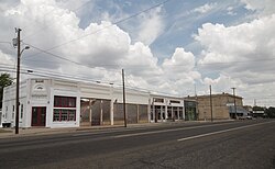
Milford dates back to the 1850s, when several men from Cherokee County came to the Mill Creek valley and bought land at 50 cents an acre from Ellis County landowner Arvin Wright. Milford was named by William R. Hudson after the factory town of Milford, Massachusetts. During 1853 the first house, a combined residence and general store belonging to William R. Hudson, was built, along with a two-story schoolhouse which served as church and community hall until it burned during the Civil War. In 1854 Wright, Hudson, and J.M. Higgins laid out town lots atop a ridge. In 1857, a gristmill began operation at the community. Milford was incorporated in 1888, with W.R. McDaniel serving as the first mayor. In 1890, the tracks of the Dallas and Waco Railway (later acquired by the Missouri–Kansas–Texas Railroad) reached the community, which became an important shipping point for area cotton farmers.

By 1892 Milford had grown to a population of 800, and had three churches, a bank, a hotel, two cotton gins, and approximately two dozen other businesses, as well as a weekly newspaper. There were now two schools in Milford, Mollie Poe's private Lone Star Institute and the community-financed Milford Academy. In 1902 the Presbyterian Synod of Texas accepted the town's offer to open the Texas Presbyterian College for Girls in Milford, and by 1925 the Dallas-Waco electric interurban railway had reached the town. The town continued to flourish, with the population soaring to 1,200 by 1929, but the population saw a slow decline due to the Great Depression, and the Presbyterian college closed due to lagging enrollment. By 1931 the population of Milford was 747, and would continue to decline as the population reached a low of 490 in 1968. The town would grow once again, and by 1990 the population was back up to 711, before dropping to 685 in 2000. [5]

2013 gas pipeline explosion

Explosion and fire

Just after 8:30AM CDT on November 14, 2013, an explosion and resulting fire occurred near the intersection of U.S. 77 and FM 308 when a Chevron Corporation liquefied petroleum gas pipeline was punctured by a Chevron drilling crew. The five man crew abandoned the rig and escaped the explosion unharmed.

Aftermath

Due to concerns about harmful air quality conditions due to the burning pipeline, and the proximity of the fire to another larger gas line, the entire town of approximately 700 residents was forced to evacuate, including Milford ISD staff and students, to the nearby town of Italy as a 1.5-mile (2.4 km) evacuation zone was established. [6]

While some residents were permitted to return to the town temporarily under police escort, the town remained evacuated through November 16 as the pipeline continued to burn. The fire also caused the postponement of a six-man football playoff game scheduled for November 15 as the players could not retrieve their gear. [7]

Chevron response

The company issued several statements through their website expressing their sincere regret to people impacted by this event which included a toll-free claims hotline which residents affected by the incident could call. The company also provided overnight accommodations at local hotels for residents due to conditions not allowing them to return home. [8]

Geography

Milford is located at 32°7′22″N96°56′48″W / 32.12278°N 96.94667°W / 32.12278; -96.94667 (32.122701, –96.946553). [9] According to the United States Census Bureau, the town has a total area of 2.5 square miles (6.4 km2), of which 0.01 square miles (0.02 km2), or 0.29%, is water. [4]

U.S. Route 77 passes through the center of town as Main Street, while Interstate 35E runs along the northern edge of town, with access from Exit 381. Downtown Dallas is 48 miles (77 km) to the north.

Demographics

Historical population
CensusPop.Note
1880 164
1890 353115.2%
1900 65385.0%
1910 76617.3%
1920 94022.7%
1930 747−20.5%
1940 7672.7%
1950 690−10.0%
1960 590−14.5%
1970 66412.5%
1980 6812.6%
1990 7114.4%
2000 685−3.7%
2010 7286.3%
2020 722−0.8%
U.S. Decennial Census [10]
Milford water tower in 2008 Milford watertower.JPG
Milford water tower in 2008
Milford racial composition as of 2020 [11]
(NH = Non-Hispanic) [lower-alpha 1]
RaceNumberPercentage
White (NH)37551.94%
Black or African American (NH)15321.19%
Native American or Alaska Native (NH)70.97%
Asian (NH)60.83%
Pacific Islander (NH)10.14%
Mixed/Multi-Racial (NH)324.43%
Hispanic or Latino 14820.5%
Total722

As of the 2020 United States census, there were 722 people, 296 households, and 217 families residing in the town.

Education

The town is served by the Milford Independent School District and is home to the Milford High School Bulldogs.

From 1902–1929, the town was home to the Texas Presbyterian College for Girls. Milford gave the school 10 acres (4.0 ha) of land and $25,000 to assist in its founding. It was later expanded to 40 acres (16 ha) before closing in 1929 and merging with Austin College in Sherman, Texas.

Milford is the setting of the 2015 sci-fi, action comedy film Lazer Team . This movie was the first feature-length film ever created by a company founded, and located in Texas called Rooster Teeth. The movie was entirely crowd funded and was given a PG-13 rating. In this movie, the Milford High School mascot is the Mustangs rather than the Bulldogs. And the school colors are red and white rather than the blue, gray and white.

Milford is also the setting of the 2016 independent comedy and LGBT film "Hurricane Bianca" starring actor and drag superstar "Bianca Del Rio" (Roy Haylock).

Related Research Articles

<span class="mw-page-title-main">Fairport Harbor, Ohio</span> Village in Ohio, United States

Fairport Harbor is a village in Lake County, Ohio, United States, along Lake Erie at the mouth of the Grand River. The population was 3,108 at the 2020 census. A far-eastern suburb of Cleveland, it is part of the Cleveland metropolitan area.

<span class="mw-page-title-main">Medford, Oklahoma</span> City in Oklahoma, United States

Medford is a city in and the county seat of Grant County, Oklahoma, United States. As of the 2010 census, the city population was 996.

<span class="mw-page-title-main">Caldwell, Texas</span> City in Texas, United States

Caldwell is a city in and the county seat of Burleson County, Texas, United States. The population was 3,993 at the 2020 census. It is part of the Bryan-College Station metropolitan area.

<span class="mw-page-title-main">Italy, Texas</span> Town in Texas, United States

Italy is a town in Ellis County, Texas, United States. Its population was 1,926 in 2020. The community was named after Italy by a settler who had visited the European country.

<span class="mw-page-title-main">Eustace, Texas</span> City in Texas, United States

Eustace is a city in Henderson County, Texas, United States. The population was 991 at the 2010 census, up from 798 at the 2000 census.

<span class="mw-page-title-main">Alvarado, Texas</span> City in Texas, United States

Alvarado is the oldest city in Johnson County, Texas. The population was 4,739 in 2020.

<span class="mw-page-title-main">West, Texas</span> City in Texas, United States

West is a city in McLennan County, Texas, United States. As of the 2020 census, the city population was 2,531. It is named after Thomas West, the first postmaster of the city. The city is located in the north-central part of Texas, approximately 70 miles (110 km) south of the Dallas-Fort Worth Metroplex, 20 miles north of Waco and 120 miles north of Austin, the state's capital.

<span class="mw-page-title-main">Cameron, Texas</span> City in Texas, United States

Cameron is a city in Milam County, Texas, United States. Its population was 5,306 at the 2020 census. It is the county seat of Milam County.

<span class="mw-page-title-main">Moran, Texas</span> City in Texas, United States

Moran is a city in southeast Shackelford County, Texas, United States. The population was 270 at the 2010 census.

<span class="mw-page-title-main">Mont Belvieu, Texas</span> City in Texas, United States

Mont Belvieu is a city in Chambers County in the U.S. state of Texas. It is just north of Interstate 10 along State Highway 146. The population was 7,654 at the 2020 census, an increase of nearly 100% from 3,835 in 2010. It is the site of the largest underground storage facility for liquefied petroleum gas in the US. The US LPG market pricing indicator is driven primarily by the Mont Belvieu market, and reported daily by the US Energy Administration.

<span class="mw-page-title-main">Ferris, Texas</span> City in Texas, United States

Ferris is a city in Dallas and Ellis counties in the U.S. state of Texas. It is 20 miles (32 km) south of downtown Dallas. The population was 2,788 in 2020.

<span class="mw-page-title-main">Ovilla, Texas</span> City in Texas, United States

Ovilla is a city in Dallas and Ellis Counties in the U.S. state of Texas. The population was 4,304 at the 2020 census.

<span class="mw-page-title-main">Rowlett, Texas</span> City in Texas, United States

Rowlett is a city in Dallas and Rockwall counties in the U.S. state of Texas, and an eastern suburb of Dallas. The total population estimate is 73,270 in 2021. It is a growing, upscale community with nearly $1.5 billion in development in the Dallas–Fort Worth metroplex, located on Lake Ray Hubbard.

<span class="mw-page-title-main">Southlake, Texas</span> City in Texas, U.S.

Southlake is a city located predominantly in Tarrant County with minor areas extending into Denton County in the U.S. state of Texas. Southlake is a suburb of Dallas/Fort Worth. As of the 2019 census estimate it had a population of 32,376.

<span class="mw-page-title-main">Venus, Texas</span> Town in Texas, United States

Venus is a town in Johnson and Ellis counties in the U.S. state of Texas. The population was 4,361 in 2020.

<span class="mw-page-title-main">Mabank, Texas</span> Town in Texas, United States

Mabank is a town in Henderson, Van Zandt and Kaufman counties in the U.S. state of Texas. Its population was 4,050 at the 2020 census.

<span class="mw-page-title-main">Scurry, Texas</span> Town in Texas, United States

Scurry is a town in Kaufman County, Texas, United States. It was incorporated in 2003. As of the 2010 census, it had a population of 681.

<span class="mw-page-title-main">Bobtown, Pennsylvania</span> Census-designated place in Pennsylvania, United States

Bobtown is an unincorporated coal town and census-designated place (CDP) in Greene County, Pennsylvania, United States. As of the 2010 census it had a population of 757.

References

  1. "2019 U.S. Gazetteer Files". United States Census Bureau. Retrieved August 7, 2020.
  2. "U.S. Census website". United States Census Bureau . Retrieved January 31, 2008.
  3. "US Board on Geographic Names". United States Geological Survey. October 25, 2007. Retrieved January 31, 2008.
  4. 1 2 "Geographic Identifiers: 2010 Census Summary File 1 (G001): Milford town, Texas". American Factfinder. U.S. Census Bureau. Archived from the original on February 13, 2020. Retrieved March 29, 2016.
  5. David Minor: Milford, TX from the Handbook of Texas Online. Retrieved January 08, 2014.
  6. Evacuations in Milford After Natural Gas Pipeline Explosion CBSDFW.COM, 2013-11-14. Retrieved 2013-11-15.
  7. Residents Briefly Allowed Back Into Evacuated Central Texas Town Archived 2013-11-17 at the Wayback Machine KWTX, 2013-11-15. Retrieved 2013-11-15.
  8. Chevron Texas Pipeline Incident Statements Archived 2014-02-02 at the Wayback Machine Chevron.com, 2014-1-24. Retrieved 2014-1-25
  9. "US Gazetteer files: 2010, 2000, and 1990". United States Census Bureau. February 12, 2011. Retrieved April 23, 2011.
  10. "Census of Population and Housing". Census.gov. Retrieved June 4, 2015.
  11. "Explore Census Data". data.census.gov. Retrieved May 22, 2022.
  12. https://www.census.gov/ [ not specific enough to verify ]
  13. "About the Hispanic Population and its Origin". www.census.gov. Retrieved May 18, 2022.
  1. Note: the US Census treats Hispanic/Latino as an ethnic category. This table excludes Latinos from the racial categories and assigns them to a separate category. Hispanics/Latinos can be of any race. [12] [13]