Marble Falls, Texas

Last updated

Marble Falls, Texas
Marble falls 2007.jpg
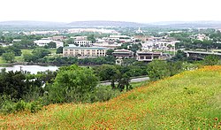
Hill view of Marble Falls, 2007
Nickname: 
Marble
Motto: 
"Lakeside Charm with Downtown Flair"
TXMap-doton-MarbleFalls.PNG
Location of Marble Falls, Texas
Burnet County MarbleFalls.svg
Coordinates: 30°34′N98°17′W / 30.567°N 98.283°W / 30.567; -98.283
Country United States
State Texas
County Burnet
Area
[1]
  Total
15.16 sq mi (39.26 km2)
  Land14.51 sq mi (37.59 km2)
  Water0.65 sq mi (1.67 km2)
Elevation
[2]
801 ft (244 m)
Population
 (2020)
  Total
7,037
  Density460/sq mi (180/km2)
Time zone UTC-6 (Central (CST))
  Summer (DST) UTC-5 (CDT)
ZIP Codes
78654, 78657
Area code 830
FIPS code 48-46584 [3]
GNIS feature ID2411030 [2]
Website ci.marble-falls.tx.us

Marble Falls is a city in Burnet County, Texas, United States. As of the 2020 United States Census, the city population was 7,037. Lake Marble Falls is part of the Highland Lakes on the Colorado River, the largest chain of lakes in Texas. [4] Marble Falls was founded by Adam Rankin Johnson [5] in 1887, a former Indian fighter and Confederate general.

Contents

History

Marble Falls was founded in 1887 by Adam Rankin "Stovepipe" Johnson, [5] a former Indian fighter and Confederate general. Johnson had visited the natural marble falls during his pre-war days as a Burnet County surveyor, and wanted to build an industrial city powered by the Colorado River. Johnson facilitated the construction of a railroad to nearby Granite Mountain in 1884, and helped plat the Marble Falls townsite. The sale of lots began in 1887, and Johnson built a home, a college, and a factory near the falls.

Max Starke Dam Max starcke dam 2013.jpg
Max Starke Dam

The town grew to a population of 1,800 within ten years.[ citation needed ]

In 1917, Marble Falls elected Ophelia Crosby "Birdie" Harwood as the first woman mayor in Texas, three years before women were allowed to vote.[ citation needed ]

When the Max Starcke Dam was completed in 1951, the marble falls which had given the town its name were submerged under the new Lake Marble Falls. The town's economy declined through the drought of the 1950s, and prospered as a tourism and retirement location, beginning in the 1970s. Beginning in the 1980s, Marble Falls has grown into the retail and entertainment center for the Highland Lakes area. [6]

Geography

Marble Falls is located on the banks of Lake Marble Falls. According to the Handbook of Texas website, the former falls were flooded by the lake, which was created by a shelf of limestone running diagonally across the Colorado River from northeast to southwest. The upper layer of limestone, brownish on the exterior but a deep blue inside, was so hard and cherty it was mistaken for marble. The falls were actually three distinct formations at the head of a canyon 1.25 miles (2.01 km) long, with a drop of some 50 feet (15 m) through the limestone strata. The natural lake and waterfall were covered when the Colorado River was dammed with the completion of Max Starcke Dam in 1951. Lake Marble Falls sits between Lake Lyndon B. Johnson to the north and Lake Travis to the south. The falls for which the city is named are now underwater but are revealed every few years when the lake is lowered.

Equally noteworthy is the huge igneous batholith called Granite Mountain looming on the town's western edge that secured Marble Falls' place in Texas history. The famed pink granite was used for the construction of the Texas State Capitol and other state government office buildings, and can also be found in the Galveston Seawall and Austin–Bergstrom International Airport.[ citation needed ]

According to the United States Census Bureau, the city has a total area of 12.2 square miles (31.6 km2), of which 11.6 square miles (30.0 km2) is land and 0.62 square miles (1.6 km2), or 5.21%, is water. [7]

Demographics

Historical population
CensusPop.Note
1890 587
1910 1,061
1920 630−40.6%
1930 86537.3%
1940 1,02118.0%
1950 2,044100.2%
1960 2,1615.7%
1970 2,2092.2%
1980 3,25247.2%
1990 4,00723.2%
2000 4,95923.8%
2010 6,07722.5%
2020 7,03715.8%
U.S. Decennial Census [8]

2020 census

Marble Falls racial composition [9]
(NH = Non-Hispanic) [a]
RaceNumberPercentage
White (NH)4,50564.02%
Black or African American (NH)1381.96%
Native American or Alaska Native (NH)230.33%
Asian (NH)1612.29%
Pacific Islander (NH)10.01%
Some Other Race (NH)120.17%
Mixed/Multi-Racial (NH)2924.15%
Hispanic or Latino 1,90527.07%
Total7,037

As of the 2020 United States census, there were 7,037 people, 2,789 households, and 1,664 families residing in the city.

Aerial view of Marble Falls, Texas Aerial photo - Marble Falls, Texas.jpg
Aerial view of Marble Falls, Texas

2010 census

As of the census [3] of 2010, there were 6,077 people, 2,486 households, and 1,542 families residing in the city. There were 28,235 housing units. The racial makeup of the city was 83.1% White, 3.9% African American, 0.7% Native American, 0.8% Asian, 9.1% from other races, and 2.4% from two or more races. Hispanic or Latino of any race were 24.2% of the population.

There were 2,486 households, out of which 29.8% had children under the age of 18 living with them, 42% were married couples living together, 14.6% had a female householder with no husband present, and 38% were non-families. The average household size was 2.41 and the average family size was 3.08.

Marble Falls, as of December 1, 2009, is the anchor of the Marble Falls, TX Micropolitan Statistical Area. The census bureau has defined this area as including all of Burnet County and has a total population of 42,896. The micropolitan area, due to close ties to nearby Austin, is a component of the Austin-Round Rock-Marble Falls, TX Consolidated Statistical Area. [11]

Education

Marble Falls Independent School District operates public schools, including Marble Falls High School.

Post-secondary institutions

Notable people

Related Research Articles

<span class="mw-page-title-main">Travis County, Texas</span> County in Texas, U.S.

Travis County is located in Central Texas. As of the 2020 census, the population was 1,290,188. It is the fifth-most populous county in Texas. Its county seat and most populous city is Austin, the state's capital. The county was established in 1840 and is named in honor of William Barret Travis, the commander of the Republic of Texas forces at the Battle of the Alamo. Travis County is part of the Austin–Round Rock–Georgetown Metropolitan Statistical Area. It is located along the Balcones Fault, the boundary between the Edwards Plateau to the west and the Blackland Prairie to the east.

<span class="mw-page-title-main">Mitchell County, Texas</span> County in Texas, United States

Mitchell County is a county in the U.S. state of Texas. As of the 2020 census, its population was 8,990. Its county seat is Colorado City. The county was created in 1876 and organized in 1881. It is named for Asa and Eli Mitchell, two early settlers and soldiers in the Texas Revolution.

<span class="mw-page-title-main">Burnet County, Texas</span> County in Texas, United States

Burnet County is a county located on the Edwards Plateau in the U.S. state of Texas. As of the 2020 census, its population was 49,130. Its county seat is Burnet. The county was founded in 1852 and later organized in 1854. It is named for David Gouverneur Burnet, the first (provisional) president of the Republic of Texas. The name of the county is pronounced with the emphasis or accent on the first syllable, just as is the case with its namesake.

<span class="mw-page-title-main">Blanco County, Texas</span> County in Texas, United States

Blanco County is a United States county located in the U.S. state of Texas. It is located in Central Texas and its county seat is Johnson City.

<span class="mw-page-title-main">Archer County, Texas</span> County in Texas, United States

Archer County is a county located in the U.S. state of Texas. As of the 2020 census, its population was 8,560. Its county seat is Archer City. It is part of the Wichita Falls metropolitan statistical area.

<span class="mw-page-title-main">Johnson City, Texas</span> City in Texas, United States

Johnson City is a city and the county seat of Blanco County, Texas, United States. The population was 1,627 at the 2020 census. Founded in 1879, it was named for early settler James Polk Johnson, nephew to Sam E. Johnson, Sr. Johnson City is part of the Texas-German belt region.

<span class="mw-page-title-main">Bertram, Texas</span> City in Texas, United States

Bertram is a city in Burnet County, Texas, United States. The population was 1,764 in the 2021 estimate.

<span class="mw-page-title-main">Burnet, Texas</span> City in Texas, United States

Burnet is a city in and the county seat of Burnet County, Texas, United States. Its population was 6,436 at the 2020 census.

<span class="mw-page-title-main">Cottonwood Shores, Texas</span> City in Texas, United States

Cottonwood Shores is a city in Burnet County, Texas, United States. The population was 1,403 at the 2020 census.

<span class="mw-page-title-main">Granite Shoals, Texas</span> City in Texas, United States

Granite Shoals is a city in Burnet County, Texas, United States with a 2020 census population of 5,129.

<span class="mw-page-title-main">Highland Haven, Texas</span> City in Texas, United States

Highland Haven is a city in Burnet County, Texas, United States. The population was 418 at the 2020 census.

<span class="mw-page-title-main">Meadowlakes, Texas</span> City in Texas, United States

Meadowlakes is a city in Burnet County, Texas, United States. The population was 1,907 at the 2020 census.

<span class="mw-page-title-main">Kingsland, Texas</span> Census-designated place in Texas, United States

Kingsland is a census-designated place (CDP) in Llano County, Texas, United States. The population was 6,030 at the 2010 census, up from 4,584 at the 2000 census. Texas Ranch to Market Road 1431 runs through the community.

<span class="mw-page-title-main">Fort Stockton, Texas</span> City in Texas, United States

Fort Stockton is a city in and the county seat of Pecos County, Texas, United States. It is located on Interstate 10, future Interstate 14, U.S. Highways 67, 285, and 385, and the Santa Fe Railroad, 329 mi (529 km) northwest of San Antonio and 240 mi (390 km) southeast of El Paso. Its population was 8,466 at the 2020 census.

<span class="mw-page-title-main">Horseshoe Bay, Texas</span> City in Texas, United States

Horseshoe Bay is a city in Llano and Burnet counties in the U.S. state of Texas.

<span class="mw-page-title-main">Lake Marble Falls</span> Hydroelectric reservoir near Marble Falls, Texas

Lake Marble Falls is a reservoir on the Colorado River in the Texas Hill Country in the United States. The reservoir was formed in 1951 by the construction of Max Starcke Dam by the Lower Colorado River Authority. Originally named Marble Falls Dam, the dam was renamed in 1962 for Max Starcke, the second general director of the LCRA. Located near the city of Marble Falls, the lake is used as a venue for aquatic recreation and for the purpose of generating hydroelectric power. It is the newest and smallest of the Texas Highland Lakes.

<span class="mw-page-title-main">Lake Lyndon B. Johnson</span> Reservoir in the United States

Lake Lyndon B. Johnson is a reservoir on the Colorado River in the Texas Hill Country about 45 miles northwest of Austin. The reservoir was formed in 1950 by the construction of Granite Shoals Dam by the Lower Colorado River Authority (LCRA). The Colorado River and the Llano River meet in the northern portion of the lake at Kingsland.

Marble Falls Independent School District ("MFISD") is a school district based in the city of Marble Falls, in Burnet County, Texas, USA which is located in the heart of the Highland Lakes region of the Texas Hill Country. The district encompasses 268 square miles (690 km2) MFISD has a growing enrollment of approximately 4,000 students.

<span class="mw-page-title-main">Greater Austin</span> Metropolitan Statistical Area in Texas, United States

The Austin–Round Rock–San Marcos metropolitan statistical area, or Greater Austin, is a five-county metropolitan area in the U.S. state of Texas, as defined by the Office of Management and Budget. The metropolitan area is situated in Central Texas on the western edge of the American South and on the eastern edge of the American Southwest, and borders Greater San Antonio to the south.

Sherwood Shores is an unincorporated community in Burnet County, Texas, United States. According to the Handbook of Texas, the community had an estimated population of 870 in 2000.

References

  1. "2019 U.S. Gazetteer Files". United States Census Bureau. Retrieved August 7, 2020.
  2. 1 2 U.S. Geological Survey Geographic Names Information System: Marble Falls, Texas
  3. 1 2 "U.S. Census website". United States Census Bureau . Retrieved January 31, 2008.
  4. "Welcome to the City of Marble Falls". Ci.marble-falls.tx.us. May 18, 1907. Archived from the original on February 17, 2010. Retrieved February 9, 2010.
  5. 1 2 Smyrl, Vivian Elizabeth (June 15, 2010). "Marble Falls, TX". Texas State Historical Association . Retrieved April 28, 2020.
  6. "Marble Falls community information and history". Marblefalls.info. Archived from the original on March 21, 2009. Retrieved February 9, 2010.
  7. "Geographic Identifiers: 2010 Demographic Profile Data (G001): Marble Falls city, Texas". U.S. Census Bureau, American Factfinder. Archived from the original on February 12, 2020. Retrieved April 23, 2014.
  8. "Census of Population and Housing". Census.gov. Retrieved June 4, 2015.
  9. "Explore Census Data". data.census.gov. Retrieved May 20, 2022.
  10. "About the Hispanic Population and its Origin". www.census.gov. Retrieved May 18, 2022.
  11. "Bulletin" (PDF). obamawhitehouse.archives.gov.
  12. "La Escalera Ranch - The Legacy - Gerald Lyda". Escalera.us. Archived from the original on October 29, 2009. Retrieved February 9, 2010.
  1. Note: the US Census treats Hispanic/Latino as an ethnic category. This table excludes Latinos from the racial categories and assigns them to a separate category. Hispanics/Latinos can be of any race. [10]