Cottonwood Shores, Texas

Last updated

Cottonwood Shores, Texas
City Hall Cottonwood Shores Texas 2024.jpg
City Hall
Motto(s): 
"People, Parks, and Prosperity"
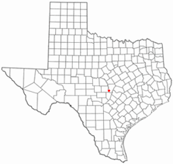
TXMap-doton-CottonwoodShores.PNG
Location of Cottonwood Shores, Texas
Burnet County CottonwoodShores.svg
Coordinates: 30°33′18″N98°19′39″W / 30.55500°N 98.32750°W / 30.55500; -98.32750
Country United States
State Texas
County Burnet
Area
[1]
  Total1.07 sq mi (2.77 km2)
  Land1.07 sq mi (2.77 km2)
  Water0.00 sq mi (0.00 km2)
Elevation
[2]
833 ft (254 m)
Population
 (2020)
  Total1,403
  Density1,300/sq mi (510/km2)
Time zone UTC-6 (Central (CST))
  Summer (DST) UTC-5 (CDT)
ZIP code
78657
Area code 830
FIPS code 48-17208 [3]
GNIS feature ID2410246 [2]
Website cottonwoodshores.org

Cottonwood Shores is a city in Burnet County, Texas, United States. The population was 1,403 at the 2020 census.

Contents

Geography

Cottonwood Shores is located in southwestern Burnet County on the south bank of the Colorado River below the outlet of Lake Lyndon B. Johnson. This is approximately 4 miles (6 km) southwest of Marble Falls, 17 miles (27 km) southwest of Burnet, the county seat, and 50 miles (80 km) west of downtown Austin.

According to the United States Census Bureau, the city has a total area of 2.0 square miles (5.1 km2), all land. [4]

Demographics

Historical population
CensusPop.Note
1990 548
2000 87760.0%
2010 1,12328.1%
2020 1,40324.9%
U.S. Decennial Census [5]

2020 census

Cottonwood Shores racial composition [6]
(NH = Non-Hispanic) [lower-alpha 1]
RaceNumberPercentage
White (NH)83559.52%
Black or African American (NH)241.71%
Native American or Alaska Native (NH)40.29%
Asian (NH)100.71%
Some Other Race (NH)30.21%
Mixed/Multi-Racial (NH)684.85%
Hispanic or Latino 45932.72%
Total1,403

As of the 2020 United States census, there were 1,403 people, 405 households, and 264 families residing in the city.

2000 census

As of the census [3] of 2000, there were 877 people, 312 households, and 232 families residing in the city. The population density was 932.9 inhabitants per square mile (360.2/km2). There were 351 housing units at an average density of 373.4 per square mile (144.2/km2). The racial makeup of the city was 88.60% White, 1.03% African American, 1.25% Native American, 0.11% Asian, 0.23% Pacific Islander, 7.75% from other races, and 1.03% from two or more races. Hispanic or Latino of any race were 19.61% of the population.

There were 312 households, out of which 39.7% had children under the age of 18 living with them, 56.4% were married couples living together, 10.6% had a female householder with no husband present, and 25.6% were non-families. 19.9% of all households were made up of individuals, and 8.3% had someone living alone who was 65 years of age or older. The average household size was 2.81 and the average family size was 3.23.

In the city, the population was spread out, with 30.0% under the age of 18, 8.7% from 18 to 24, 30.8% from 25 to 44, 19.2% from 45 to 64, and 11.4% who were 65 years of age or older. The median age was 34 years. For every 100 females, there were 104.0 males. For every 100 females age 18 and over, there were 102.6 males.

The median income for a household in the city was $36,094, and the median income for a family was $37,656. Males had a median income of $28,333 versus $17,500 for females. The per capita income for the city was $17,664. About 7.6% of families and 9.7% of the population were below the poverty line, including 12.8% of those under age 18 and 3.1% of those age 65 or over.

Related Research Articles

<span class="mw-page-title-main">Burnet County, Texas</span> County in Texas, United States

Burnet County is a county located on the Edwards Plateau in the U.S. state of Texas. As of the 2020 census, its population was 49,130. Its county seat is Burnet. The county was founded in 1852 and later organized in 1854. It is named for David Gouverneur Burnet, the first (provisional) president of the Republic of Texas. The name of the county is pronounced with the emphasis or accent on the first syllable, just as is the case with its namesake.

<span class="mw-page-title-main">Cottonwood, Minnesota</span> City in Minnesota, United States

Cottonwood is a city in Lyon County, Minnesota, United States. The population was 1,149 at the 2020 census.

<span class="mw-page-title-main">Meridian, Texas</span> City in and county seat of Bosque County, Texas, United States

Meridian is a city in and the county seat of Bosque County in Texas, United States. It is forty-seven miles northwest of Waco. The population was 1,396 at the 2020 census.

<span class="mw-page-title-main">Bertram, Texas</span> City in Texas, United States

Bertram is a city in Burnet County, Texas, United States. The population was 1,764 at the 2021 estimate.

<span class="mw-page-title-main">Granite Shoals, Texas</span> City in Texas, United States

Granite Shoals is a city in Burnet County, Texas, United States with a 2020 census population of 5,129.

<span class="mw-page-title-main">Highland Haven, Texas</span> City in Texas, United States

Highland Haven is a city in Burnet County, Texas, United States. The population was 418 at the 2020 census.

<span class="mw-page-title-main">Meadowlakes, Texas</span> City in Texas, United States

Meadowlakes is a city in Burnet County, Texas, United States. The population was 1,907 at the 2020 census.

<span class="mw-page-title-main">Coleman, Texas</span> City in Texas, United States

Coleman is a town in and the county seat of Coleman County, Texas, United States. As of the 2020 census, its population was 3,912.

<span class="mw-page-title-main">Savoy, Texas</span> City in Texas, United States

Savoy is a city in Fannin County, Texas, United States. The population is 712 as of the 2020 census.

Berryville is a town in Henderson County, Texas, United States. The population was 824 at the 2020 census, down from 975 at the 2010 census.

<span class="mw-page-title-main">Cottonwood, Kaufman County, Texas</span> City in Texas, United States

Cottonwood is a city in Kaufman County, Texas, United States. The population was 181 at the 2020 census.

Ames is a city in Liberty County, Texas, United States. The population was 937 at the 2020 census.

<span class="mw-page-title-main">Buchanan Dam, Texas</span> Census-designated place in Texas, United States

Buchanan Dam is a census-designated place (CDP) in Llano County, Texas, United States. The population was 1,519 at the 2010 census, down from 1,688 at the 2000 census.

<span class="mw-page-title-main">Sunrise Beach Village, Texas</span> City in Texas, United States

Sunrise Beach Village is a city in Llano County, Texas, United States. The village was established in 1973. The population was 739 at the 2020 census.

<span class="mw-page-title-main">Moody, Texas</span> City in Texas, United States

Moody is a city in McLennan County, Texas, United States. The population was 1,376 at the 2020 census. It is part of the Waco Metropolitan Statistical Area.

<span class="mw-page-title-main">LaCoste, Texas</span> City in Texas, United States

La Coste is a city in Medina County, Texas, United States. The population was 1,077 at the 2010 census. It is part of the San Antonio Metropolitan Statistical Area.

<span class="mw-page-title-main">La Grulla, Texas</span> City in Texas, United States

La Grulla is a city in Starr County, Texas, United States, founded by Juan Santiago Longoria in 1836. The population was 1,222 at the 2020 census.

<span class="mw-page-title-main">Rollingwood, Texas</span> City in Texas, United States

Rollingwood is a city in Travis County, Texas, United States. Part of the Austin–Round Rock metropolitan area, the population was 1,467 at the 2020 census.

<span class="mw-page-title-main">Horseshoe Bay, Texas</span> City in Texas, United States

Horseshoe Bay is a city in Llano and Burnet counties in the U.S. state of Texas.

<span class="mw-page-title-main">Niederwald, Texas</span> City in Texas, United States

Niederwald is a city in Caldwell and Hays counties in the U.S. state of Texas. The population was 668 at the 2020 census. Niederwald means "low forest", or "low wood", in German. It was named Niederwald by the German founders of the town. This region of Central Texas was settled in the 1800s primarily by Germans and European emigrants and is referred to as the Texas-German belt by locals.

References

  1. "2019 U.S. Gazetteer Files". United States Census Bureau. Retrieved August 7, 2020.
  2. 1 2 U.S. Geological Survey Geographic Names Information System: Cottonwood Shores, Texas
  3. 1 2 "U.S. Census website". United States Census Bureau . Retrieved January 31, 2008.
  4. "Geographic Identifiers: 2010 Demographic Profile Data (G001): Cottonwood Shores city, Texas". U.S. Census Bureau, American Factfinder. Archived from the original on February 12, 2020. Retrieved April 23, 2014.
  5. "Census of Population and Housing". Census.gov. Retrieved June 4, 2015.
  6. "Explore Census Data". data.census.gov. Retrieved May 20, 2022.
  7. "About the Hispanic Population and its Origin". www.census.gov. Retrieved May 18, 2022.
  1. Note: the US Census treats Hispanic/Latino as an ethnic category. This table excludes Latinos from the racial categories and assigns them to a separate category. Hispanics/Latinos can be of any race. [7]