
The Mohawk River is a 149-mile-long (240 km) river in the U.S. state of New York. It is the largest tributary of the Hudson River. The Mohawk flows into the Hudson in Cohoes, New York, a few miles north of the state capital of Albany. The river is named for the Mohawk Nation of the Iroquois Confederacy. A major waterway, in the early 19th century, the river's east-west valley provided the setting and water for development of the Erie Canal, as a key to developing New York. The largest tributary, the Schoharie Creek, accounts for over one quarter (26.83%) of the Mohawk River's watershed. Another main tributary is the West Canada Creek, which makes up for 16.33% of the Mohawk's watershed.

Battle Creek is a river that begins in the south-eastern region of the Canadian province of Alberta, near the border with Saskatchewan, in the Cypress Hills Interprovincial Park. From Alberta, Battle Creek flows east and across the border into Saskatchewan. It flows south out of Saskatchewan across the Canada–United States border into Montana, where it joins the Milk River in Blaine County, Montana.

The Trinity River is a 710-mile (1,140 km) river, the longest with a watershed entirely within the U.S. state of Texas. It rises in extreme northern Texas, a few miles south of the Red River. The headwaters are separated by the high bluffs on the southern side of the Red River.

The Pocomoke River stretches approximately 66 miles (106 km) from southern Delaware through southeastern Maryland in the United States. At its mouth, the river is essentially an arm of Chesapeake Bay, whereas the upper river flows through a series of relatively inaccessible wetlands called the Great Cypress Swamp, largely populated by Loblolly Pine, Red Maple and Bald Cypress. The river is the easternmost river that flows into Chesapeake Bay. "Pocomoke", though traditionally interpreted as "dark water" by local residents, is now agreed by scholars of the Algonquian languages to be derived from the words for "broken ground."

A blackwater river is a type of river with a slow-moving channel flowing through forested swamps or wetlands. Most major blackwater rivers are in the Amazon Basin and the Southern United States. The term is used in fluvial studies, geology, geography, ecology, and biology. Not all dark rivers are blackwater in that technical sense. Some rivers in temperate regions, which drain or flow through areas of dark black loam, are simply black due to the color of the soil; these rivers are black mud rivers. There are also black mud estuaries.
Cypress is an unincorporated community in Harris County, Texas, United States, located completely inside the extraterritorial jurisdiction of the City of Houston. The Cypress area is located along U.S. Route 290 is twenty-four miles (35 km) northwest of Downtown Houston. The Cypress urban cluster ranks 50th in the top 100 highest-income urban areas in the United States.

The Nacimiento River is a 64.8-mile-long (104.3 km) river in southern Monterey County and northern San Luis Obispo County, California. A large portion of the river's run is on military reservations. The river's upper reaches are inside Fort Hunter Liggett, Lake Nacimiento is in the middle and the lower reaches are inside Camp Roberts. It is the largest tributary of the Salinas River in terms of streamflow.
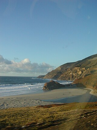
The Little Sur River is a 25.4-mile (40.9 km) long river on the Central Coast of California. The river and its main tributary, the South Fork, drain a watershed of about 40 square miles (100 km2) of the Big Sur area, a thinly settled region of the Central California coast where the Santa Lucia Mountains rise abruptly from the Pacific Ocean. The South Fork and the North Fork both have their headwaters in the Ventana Wilderness, straddling Mount Pico Blanco. Portions west of the national forest and Old Coast Road lie within the El Sur Ranch. Some portions of the North Fork are on land owned by Granite Rock Company of Watsonville, California, which has owned the mineral rights to 2,800 acres (1,100 ha) on Mount Pico Blanco since 1963. The North and South forks converge about 2 miles (3.2 km) from the coast where the river enters the Pacific Ocean.

Houston, the most populous city in the Southern United States, is located along the upper Texas Gulf Coast, approximately 50 miles (80 km) northwest of the Gulf of Mexico at Galveston. The city, which is the ninth-largest in the United States by area, covers 601.7 square miles (1,558 km2), of which 579.4 square miles (1,501 km2), or 96.3%, is land and 22.3 square miles (58 km2), or 3.7%, is water.

The North Fork River or the North Fork of White River is a 109-mile-long (175 km) tributary of the White River, into which it flows near Norfork, Arkansas.
Cabin John Creek is a tributary stream of the Potomac River in Montgomery County, Maryland. The watershed covers an area of 26 square miles (67 km2). The headwaters of the creek originate in the city of Rockville, and the creek flows southward for 10.9 miles (17.5 km) to the Potomac River.
Blue Cypress Lake, originally called Lake Wilmington, is a lake in Indian River County of the Treasure Coast in Florida. It is the largest lake in the Treasure Coast and Indian River County. It is the headwaters lake of the St. Johns River. The sources of water are several creeks from the south, two from the west, and Moonshine Bay from the North that flow into the lake. All the water flows out of the lake to the northwest into M Canal and Zigzag Canal. The lake is over 6,500 acres (26 km2) in size, 21 mi (34 km) in circumference, and has an average depth of 8 feet (2.4 m). The lake is 2,100 acres (8.5 km2) larger than Lake Washington, 27 mi (43 km) north of this lake. The lake's name comes from the blue appearance of the cypress trees as the morning sun's rays reflect off the water. A fishing camp called Blue Cypress Lakeside Cabins is 4 mi (6.4 km) off State Road 60. The Blue Cypress Village is south of the small boat canal from the fish camp.

Cypress Creek Emergency Medical ServicesAssociation, also known as Cypress Creek EMS (CCEMS) was a private, non-profit emergency medical service provider for Harris County ESD 11 in North Harris County, within greater Houston, Texas. In 2021, CCEMS declared bankruptcy and operations ceased in mid 2022. In late 2022, the remaining assets, branding, and trademarks were bought by Viking Enterprises, DBA City Ambulance Service. All ambulances in use by CCEMS are Mobile Intensive Care Units (MICU), with at least one Paramedic, making all ambulances ALS units. Cypress Creek EMS provided 911 service in North Harris County, provided bicycle medic teams for special events, provided tactical EMS support for federal, state, and local law enforcement, and operated an accredited educational institution.
Shingle Creek is a small waterway in central Florida that is generally considered to be the northernmost headwaters of the Everglades watershed. It is named after the cypress trees that lined the bank in the late 19th century, which were used to make wood shingles. The stream and surrounding areas are protected wetlands.

Coyote Creek is a principal tributary of the San Gabriel River in northwest Orange County and southeast Los Angeles County, California. It drains a land area of roughly 41.3 square miles (107 km2) covering eight major cities, including Brea, Buena Park, Fullerton, Hawaiian Gardens, La Habra, Lakewood, La Palma, and Long Beach. Some major tributaries of the creek in the highly urbanized watershed include Brea Creek, Fullerton Creek, and Carbon Creek. The mostly flat creek basin is separated by a series of low mountains, and is bounded by several small mountain ranges, including the Chino Hills, Puente Hills, and West Coyote Hills.
Big Cypress Creek is an 86-mile-long (138 km) river in Texas. It is part of the Red River watershed, with its water eventually flowing to the Atchafalaya River through the Atchafalaya Basin and entering the Gulf of Mexico.

Onion Creek is a small tributary stream of the Colorado River in Texas. It begins 12 mi (19 km) southeast of Johnson City, Blanco County, Texas, and flows approximately 79 mi (127 km) eastward into the Colorado River, 2 mi (3.2 km) northwest of Garfield in Travis County, Texas. While areas surrounding the creek's origin in Blanco County are primarily rural, areas closer to its mouth in Travis County have more urban and industrial development. Passing near Dripping Springs, Driftwood, and Onion Creek, Onion Creek is the source of the waterfalls in McKinney Falls State Park. Onion Creek's watershed spans an area of 211 sq mi (550 km2).

Spring Creek is a creek that divides Harris and Montgomery County in Southeast Texas. It is the only natural creek in both Harris and Montgomery County. The Creek flows into the west fork of the San Jacinto River west of Lake Houston. Spring Creek flows through the cities of Tomball, the northern part of Spring, The Woodlands, and Kingwood.

The Fall Kill is a creek in Dutchess County, New York, United States. The stream is approximately 38 miles (61 km) long, and joins the Hudson River in the city of Poughkeepsie.


