Hays County is a county in the central portion of the U.S. state of Texas. It is part of the Austin-Round Rock metropolitan area. As of the 2020 census, its official population had reached 241,067. The county seat is San Marcos. Hays, along with Comal and Kendall Counties, was listed in 2017 as one of the nation's fastest-growing counties with a population of at least 10,000. From 2015 to 2016, Hays County, third on the national list, had nearly 10,000 new residents during the year.

Wimberley is a village in Hays County, Texas, United States. It is still predominantly a ranching area outside of town. The population was 2,839 at the 2020 census.

The Texas Hill Country is a geographic region of Central and South Texas, forming the southeast part of the Edwards Plateau. Given its location, climate, terrain, and vegetation, the Hill Country can be considered the border between the American Southeast and Southwest. The region represents the very remote rural countryside of Central Texas, but also is home to growing suburban neighborhoods and affluent retirement communities.

The Ouachita River is a 605-mile-long (974 km) river that runs south and east through the U.S. states of Arkansas and Louisiana, joining the Tensas River to form the Black River near Jonesville, Louisiana. It is the 25th-longest river in the United States.

The Dolores River is a tributary of the Colorado River, approximately 241 miles (388 km) long, in the U.S. states of Colorado and Utah. The river drains a rugged and arid region of the Colorado Plateau west of the San Juan Mountains. Its name derives from the Spanish El Rio de Nuestra Señora de Dolores, River of Our Lady of Sorrows. The river was explored and possibly named by Juan Maria Antonio Rivera during a 1765 expedition from Santa Fe.

The Stillaguamish River is a river in the northwestern region of the U.S. state of Washington. It is mainly composed of two forks, the longer North Fork Stillaguamish and the South Fork Stillaguamish. The two forks join near Arlington. From there the Stillaguamish River proper flows for 22 miles (35 km) to Puget Sound. The river's watershed drains part of the Cascade Range north of Seattle.
In hydrology, discharge is the volumetric flow rate of a stream. It equals the product of average flow velocity and the cross-sectional area. It includes any suspended solids, dissolved chemicals, or biologic material in addition to the water itself. Terms may vary between disciplines. For example, a fluvial hydrologist studying natural river systems may define discharge as streamflow, whereas an engineer operating a reservoir system may equate it with outflow, contrasted with inflow.

The Guadalupe River runs from Kerr County, Texas, to San Antonio Bay on the Gulf of Mexico, with an average temperature of 17.75 degrees Celsius. It is a popular destination for rafting, fly fishing, and canoeing. Larger cities along it include Kerrville, New Braunfels, Seguin, Gonzales, Cuero, and Victoria. It has several dams along its length, the most notable of which, Canyon Dam, forms Canyon Lake northwest of New Braunfels.

Noonday Creek is a 20.2-mile-long (32.5 km) stream in Cobb and Cherokee counties in the U.S. state of Georgia. The stream begins near Kennesaw Mountain and ends at Lake Allatoona.

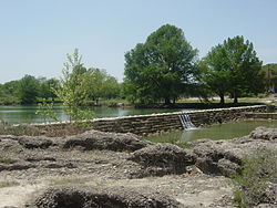
The San Marcos River rises from the San Marcos Springs, the location of the Meadows Center for Water and the Environment, in San Marcos, Texas. The springs are home to several threatened or endangered species, including the Texas blind salamander, fountain darter, and Texas wild rice. The river is a popular recreational area, and is frequented for tubing, canoeing, swimming, and fishing.

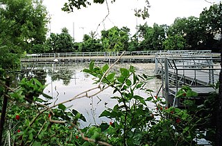
The Edwards Aquifer is one of the most prolific artesian aquifers in the world. Located on the eastern edge of the Edwards Plateau in the U.S. state of Texas, it is the source of drinking water for two million people, and is the primary water supply for agriculture and industry in the aquifer's region. Additionally, the Edwards Aquifer feeds the Comal and San Marcos Springs, provides springflow for recreational and downstream uses in the Nueces, San Antonio, Guadalupe, and San Marcos river basins, and is home to several unique and endangered species.
Streamflow, or channel runoff, is the flow of water in streams and other channels, and is a major element of the water cycle. It is one runoff component, the movement of water from the land to waterbodies, the other component being surface runoff. Water flowing in channels comes from surface runoff from adjacent hillslopes, from groundwater flow out of the ground, and from water discharged from pipes. The discharge of water flowing in a channel is measured using stream gauges or can be estimated by the Manning equation. The record of flow over time is called a hydrograph. Flooding occurs when the volume of water exceeds the capacity of the channel.

Canyon Lake is a reservoir on the Guadalupe River in the Texas Hill Country in the United States. Canyon Lake is a U.S. Army Corps of Engineers reservoir formed on the Guadalupe River in Comal County by Canyon Dam, which is located about sixteen miles northwest of New Braunfels. The dam, lake, and all adjacent property are managed by the U.S. Army Corps Of Engineers. Water rights, waste water treatment, and hydroelectric generating facilities are managed by the Guadalupe-Blanco River Authority. Construction of the dam began in 1958 and was completed in 1964. The reservoir serves to provide flood control and water supply for the communities downstream from the dam. The lake is also a popular recreational destination.

The Mid-Atlantic United States flood of 2006 was a significant flood that affected much of the Mid-Atlantic region of the eastern United States. The flooding was very widespread, affecting numerous rivers, lakes and communities from Upstate New York to North Carolina. It was widely considered to be the worst flooding in the region since Hurricane David in 1979. It was also one of the worst floodings in the United States since Hurricane Katrina in August 2005. At least 16 deaths were related to the flooding.
Floods in the United States are generally caused by excessive rainfall, excessive snowmelt, and dam failure. Below is a list of flood events that were of significant impact to the country during the 20th century, from 1900 through 1999, inclusive.
San Marcos Springs is the second largest natural cluster of springs in Texas. The springs are located in the city of San Marcos, Texas, about 30 miles (48 km) southwest of Austin and 46 miles (74 km) northeast of San Antonio.

Onion Creek is a small tributary stream of the Colorado River in Texas. It begins 12 mi (19 km) southeast of Johnson City, Blanco County, Texas, and flows approximately 79 mi (127 km) eastward into the Colorado River, 2 mi (3.2 km) northwest of Garfield in Travis County, Texas. While areas surrounding the creek's origin in Blanco County are primarily rural, areas closer to its mouth in Travis County have more urban and industrial development. Passing near Dripping Springs, Driftwood, and Onion Creek, Onion Creek is the source of the waterfalls in McKinney Falls State Park. Onion Creek's watershed spans an area of 211 sq mi (550 km2).

The 2011 flooding on the Musselshell River in Montana began about May 21, affecting large parts of central Montana. At Mosby, Montana, the river crested at 16 feet (4.9 m) on Monday, May 23. The flood level at Mosby is 8 feet (2.4 m) and the record crest at that point along the Musselshell is 17.7 feet (5.4 m), set in 1993. The flooding was caused by up to 8 inches (200 mm) of rain combined with snowmelt.

Morris Dam is a concrete gravity dam across the San Gabriel River in the U.S. state of California. It impounds Morris Reservoir, directly downstream of San Gabriel Dam.
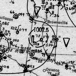
In early September 1921, the remnants of a Category 1 hurricane brought damaging floods to areas of Mexico and the U.S. state of Texas, particularly in the San Antonio region. On September 4, a tropical cyclone developed in the southwestern Gulf of Mexico near the Bay of Campeche. Moving slowly in a general westward direction, the disturbance reached hurricane intensity on September 7 prior to making landfall south of Tampico, Mexico the following day. The storm weakened over land, and lost cyclonic characteristics later that day. However, a nearby high-pressure area forced the remnants of the system northward into Texas. Due to an orographic lifting effect, the remnants were able to produce torrential and record rainfall over the state. Precipitation peaked over Central Texas, where the highest rainfall amount measured was 40 in (1,016 mm) near Thrall, Texas; this was the fourth-highest tropical cyclone-related rainfall total in Texas since record keeping began. Similarly, an observation of 36.40 in (925 mm) elsewhere in Williamson County, Texas ranked as the sixth-highest tropical cyclone-related rainfall total for the state. The high precipitation totals set nationwide records which would stand for several years.