
The Sabine River is a 360-mile (580 km) long river in the Southern U.S. states of Texas and Louisiana, From the 32nd parallel north and downstream, it serves as part of the boundary between the two states and empties into Sabine Lake, an estuary of the Gulf of Mexico.
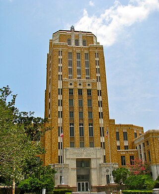
Jefferson County is a county in the Coastal Plain or Gulf Prairie region of Southeast Texas. The Neches River forms its northeastern boundary. As of the 2020 census, the population was 256,526. The county seat is Beaumont. Jefferson County has the highest percentage of African Americans in the state of Texas.
Kountze is a city in and the county seat of Hardin County, Texas, United States. The population was 1,981 at the 2020 census. The city is part of the Beaumont–Port Arthur Metropolitan Statistical Area.

The Gulf Intracoastal Waterway (GIWW) is the portion of the Intracoastal Waterway located along the Gulf Coast of the United States. It is a navigable inland waterway running approximately 1,300 mi (2,100 km) from Saint Marks, Florida, to Brownsville, Texas.

East Texas is a broadly defined cultural, geographic, and ecological region in the eastern part of the U.S. state of Texas that comprises most of 41 counties. It is primarily divided into Northeast and Southeast Texas. Most of the region consists of the Piney Woods ecoregion. East Texas can sometimes be defined only as the Piney Woods. At the fringes, towards Central Texas, the forests expand outward toward sparser trees and eventually into open plains.

Sabine Lake is a bay on the Gulf coasts of Texas and Louisiana, located approximately 90 miles (140 km) east of Houston and 160 miles (260 km) west of Baton Rouge, adjoining the city of Port Arthur. The lake is formed by the confluence of the Neches and Sabine Rivers and connects to the Gulf of Mexico through Sabine Pass. It forms part of the Texas–Louisiana border, falling within Jefferson and Orange Counties in Texas and Cameron Parish, Louisiana.

Southeast Texas is a cultural and geographic region in the U.S. state of Texas, bordering Southwest Louisiana and its greater Acadiana region to the east. Being a part of East Texas, the region is geographically centered on the Greater Houston and Beaumont–Port Arthur metropolitan statistical areas with a combined population of 7,662,325 according to the 2020 U.S. census.

The Piney Woods is a temperate coniferous forest terrestrial ecoregion in the Southern United States covering 54,400 square miles (141,000 km2) of East Texas, southern Arkansas, western Louisiana, and southeastern Oklahoma. These coniferous forests are dominated by several species of pine as well as hardwoods including hickory and oak. Historically the most dense part of this forest region was the Big Thicket though the lumber industry dramatically reduced the forest concentration in this area and throughout the Piney Woods during the 19th and 20th centuries. The World Wide Fund for Nature considers the Piney Woods to be one of the critically endangered ecoregions of the United States. The United States Environmental Protection Agency (EPA) defines most of this ecoregion as the South Central Plains.
The Lower Neches Valley Authority was established in 1933 by the state legislature as a district to store, control, conserve, and utilize the water of the lower Neches River valley in Texas. The LNVA, the second river district created by the state of Texas, is currently one of 23 river districts in the state. It includes all of Jefferson, Hardin, and Tyler counties and parts of Jasper, Liberty, and Chambers counties.

The Big Thicket is the name given to a somewhat imprecise region of a heavily forested area of Southeast Texas in the United States. This area represents a portion of the mixed pine-hardwood forests or "Piney Woods" of the Southeast US. The National Park Service established the Big Thicket National Preserve (BTNP) within the region in 1974 and it is recognized as a biosphere reserve by UNESCO. Although the diversity of animals in the area is high for a temperate zone with over 500 vertebrates, it is the complex mosaic of ecosystems and plant diversity that is particularly remarkable. Biologists have identified at least eight, and up to eleven, ecosystems in the Big Thicket area. More than 160 species of trees and shrubs, 800 herbs and vines, and 340 types of grasses are known to occur in the Big Thicket, and estimates as high as over 1000 flowering plant species and 200 trees and shrubs have been made, plus ferns, carnivorous plants, and more. The Big Thicket has historically been the most dense forest region in Texas.
Sam Rayburn Reservoir is a reservoir in the United States in Deep East Texas, 70 miles (110 km) north of Beaumont. The reservoir is fed by the Angelina River, the major tributary of the Neches River. The Reservoir is upstream of the Big Thicket National Preserve.

The Port of Beaumont is a deep-water port located in Beaumont, Texas near the mouth of the Neches River.

Pine Island Bayou is a tributary of the Neches River located in southeast Texas. It runs about 55 miles from the northwest corner of Hardin County, Texas and flows in a southeastern direction through western Hardin County, turning east and defining the southern Hardin and Jefferson County boundary for about 20 miles until its confluence with the Neches River. Two significant tributaries of Pine Island Bayou are Mayhaw Creek and Little Pine Island Bayou. The lower ten miles of Pine Island Bayou and much of Little Pine Island Bayou are protected from development in the Big Thicket National Preserve. Excluding the last few miles north of Beaumont, the area is not densely populated, and some small towns include Sour Lake and Saratoga, the latter the birthplace of country singer George Jones.

B A Steinhagen Reservoir is located near the town of Jasper, Texas in the east Texas Piney Woods at 30.85 North Latitude and 94.19 West Longitude. The borders of Tyler County and Jasper County are defined by the bed of the Neches River, and therefore bisect the lake on a North/South line. The lake was created as part of a project that focused on creating lakes for recreation, power generation, and water conservation on the Neches River and the Angelina River. For many years, locals have referred to both the lake and dam as "Dam B".
Martin Dies Jr. State Park is a 705-acre state park located along U.S. Route 190 on the banks of the Steinhagen Reservoir in Jasper and Tyler counties in Texas. The park is managed by the Texas Parks and Wildlife Department. The park consists of three units; Hen House Ridge Unit, Walnut Ridge Unit and Cherokee Unit. Cherokee Unit is a day use area only, whereas the other two units allow camping.

Village Creek is a blackwater tributary of the Neches River in Texas, United States. It arises in northwestern Hardin County outside the community of Village Mills. Due to the waterway's isolation and absence of impoundments, it is known to be pristine supporting cypress swamps and hardwood forests, as well as many rare and endangered species. It is 63 miles (101 km) long and average streamflow at the mouth is approximately 1,000 cubic feet per second (28 m3/s). It passes through three conservation areas on the way south, being: the Big Thicket National Preserve - Village Creek Corridor Unit, Roy E. Larsen Sandyland Sanctuary, and Village Creek State Park.

The Neches River National Wildlife Refuge is a 7,000-acre (28 km2) protected area of Texas managed by the United States Fish and Wildlife Service as part of the National Wildlife Refuge System. It is located in the rolling hills of East Texas near Jacksonville.

The Sabine–Neches Waterway is located in southeast Texas and Calcasieu Parish, Louisiana, United States. The waterway includes parts of the Neches River, Sabine River, Sabine Lake, and Taylor Bayou. The waterway ranks as third-busiest waterway in the U.S. in terms of cargo tonnage, according to the American Association of Port Authorities. It also ranks as the top bulk liquid cargo waterway, the top U.S. crude-oil importer, and is projected to become the largest LNG exporter in the United States. The Gulf Intracoastal Waterway crosses the waterway near Port Arthur.
The Little Sandy National Wildlife Refuge is National Wildlife Refuge of 3,802 acres in Wood County, Texas. Unlike most National Wildlife Refuges maintained by the U.S. Fish and Wildlife Service, the public is not allowed access to the refuge. The land is privately owned, but protected by a conservation easement.

The U.S. state of Texas has a series of estuaries along its coast on the Gulf of Mexico, most of them bounded by the Texas barrier islands. Estuaries are coastal bodies of water in which freshwater from rivers mixes with saltwater from the sea. Twenty-one drainage basins terminate along the Texas coastline, forming a chain of seven major and five minor estuaries: listed from southwest to northeast, these are the Rio Grande Estuary, Laguna Madre, the Nueces Estuary, the Mission–Aransas Estuary, the Guadalupe Estuary, the Colorado–Lavaca Estuary, East Matagorda Bay, the San Bernard River and Cedar Lakes Estuary, the Brazos River Estuary, Christmas Bay, the Trinity–San Jacinto Estuary, and the Sabine–Neches Estuary. Each estuary is named for its one or two chief contributing rivers, excepting Laguna Madre, East Matagorda Bay, and Christmas Bay, which have no major river sources. The estuaries are also sometimes referred to by the names of their respective primary or central water bodies, though each also includes smaller secondary bays, inlets, or other marginal water bodies.

 Rainbow and Veteran's Memorial bridges near river mouth
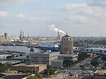 View of a portion of Port of Beaumont
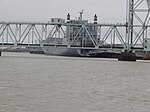 Port of Beaumont looking toward wharfs 5,6,&7
 1st Air Cavalry Brigade Takes Birds to Port of Beaumont
 River view at one of the petro-chemical facilities
 The CPKC, ex-KCS Railway bridge over the Neches River in Beaumont is a major transportation link for the region.


