The Neches River begins in Van Zandt County west of Rhine Lake and flows for 416 miles (669 km) through the piney woods of east Texas, defining the boundaries of 14 counties on its way to its mouth on Sabine Lake near the Rainbow Bridge. Two major reservoirs, Lake Palestine and B. A. Steinhagen Reservoir are located on the Neches. The Angelina River is a major tributary with its confluence at the north of Lake B. A. Steinhagen. Tributaries to the south include Village Creek and Pine Island Bayou, draining much of the Big Thicket region, both joining the Neches a few miles north of Beaumont. Towns and cities located along the river including Tyler, Lufkin, and Silsbee, although significant portions of the Neches River are undeveloped and flow through protected natural lands. In contrast, the lower 40 miles of the river are a major shipping channel, highly industrialized, with a number of cities and towns concentrated in the area including Beaumont, Vidor, Port Neches, Nederland, Groves, and Port Arthur.

Everglades National Park is a national park of the United States that protects the southern twenty percent of the original Everglades in Florida. The park is the largest tropical wilderness in the United States and the largest wilderness of any kind east of the Mississippi River. An average of one million people visit the park each year. Everglades is the third-largest national park in the contiguous United States after Death Valley and Yellowstone. UNESCO declared the Everglades & Dry Tortugas Biosphere Reserve in 1976 and listed the park as a World Heritage Site in 1979, and the Ramsar Convention included the park on its list of Wetlands of International Importance in 1987. Everglades is one of only three locations in the world to appear on all three lists.

The Allegheny National Forest is a National Forest in Northwestern Pennsylvania, about 100 miles northeast of Pittsburgh. The forest covers 513,175 acres of land. Within the forest is Kinzua Dam, which impounds the Allegheny River to form Allegheny Reservoir. The administrative headquarters for the Allegheny National Forest is in Warren. The Allegheny National Forest has two ranger stations, one in Marienville, Forest County, and the other in Bradford, McKean County.

The Piney Woods is a temperate coniferous forest terrestrial ecoregion in the Southern United States covering 54,400 square miles (141,000 km2) of East Texas, southern Arkansas, western Louisiana, and southeastern Oklahoma. These coniferous forests are dominated by several species of pine as well as hardwoods including hickory and oak. Historically the most dense part of this forest region was the Big Thicket though the lumber industry dramatically reduced the forest concentration in this area and throughout the Piney Woods during the 19th and 20th centuries. The World Wide Fund for Nature considers the Piney Woods to be one of the critically endangered ecoregions of the United States. The United States Environmental Protection Agency (EPA) defines most of this ecoregion as the South Central Plains.

The Big Thicket is the name given to a somewhat imprecise region of a heavily forested area of Southeast Texas in the United States. This area represents a portion of the mixed pine-hardwood forests or "Piney Woods" of the Southeast US. The National Park Service established the Big Thicket National Preserve (BTNP) within the region in 1974 and it is recognized as a biosphere reserve by UNESCO. Although the diversity of animals in the area is high for a temperate zone with over 500 vertebrates, it is the complex mosaic of ecosystems and plant diversity that is particularly remarkable. Biologists have identified at least eight, and up to eleven, ecosystems in the Big Thicket area. More than 160 species of trees and shrubs, 800 herbs and vines, and 340 types of grasses are known to occur in the Big Thicket, and estimates as high as over 1000 flowering plant species and 200 trees and shrubs have been made, plus ferns, carnivorous plants, and more. The Big Thicket has historically been the most dense forest region in Texas.

The Unicoi Mountains are a mountain range rising along the border between Tennessee and North Carolina in the southeastern United States. They are part of the Blue Ridge Mountain Province of the Southern Appalachian Mountains. The Unicois are located immediately south of the Great Smoky Mountains and immediately west of the Cheoah Mountains. Most of the range is protected as a national forest, namely the Cherokee National Forest on the Tennessee side and the Nantahala National Forest on the North Carolina side— although some parts have been designated as wilderness areas and are thus more strictly regulated.

Inyo National Forest is a United States National Forest covering parts of the eastern Sierra Nevada of California and the White Mountains of California and Nevada. The forest hosts several superlatives, including Mount Whitney, the highest point in the contiguous United States; Boundary Peak, the highest point in Nevada; and the Ancient Bristlecone Pine Forest, which protects the oldest living trees in the world. The forest, encompassing much of the Owens Valley, was established by Theodore Roosevelt as a way of sectioning off land to accommodate the Los Angeles Aqueduct project in 1907, making the Inyo National Forest one of the least wooded forests in the U.S. National Forest system.

Klamath National Forest is a 1,737,774-acre national forest, in the Klamath Mountains and Cascade Range, located in Siskiyou County in northern California, but with a tiny extension into southern Jackson County in Oregon. The forest contains continuous stands of ponderosa pine, Jeffrey pine, Douglas fir, red fir, white fir, lodgepole pine, Baker Cypress, and incense cedar. Old growth forest is estimated to cover some 168,000 acres (680 km2) of forest land. Forest headquarters are located in Yreka, California. There are local ranger district offices located in Fort Jones, Happy Camp, and Macdoel, all in California. The Klamath was established on May 6, 1905. This forest includes the Kangaroo Lake and the Sawyers Bar Catholic Church, which are located within the boundaries of the Forest. The Forest is managed jointly with the Butte Valley National Grassland.
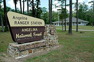
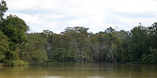
Angelina National Forest is a United States National Forest, one of four located in the piney woods region of Texas. The 153,180-acre (619.9 km2) Angelina National Forest is located in East Texas in parts of San Augustine, Angelina, Jasper and Nacogdoches counties. It is managed together with the three other National Forests in Texas from Forest Service offices in Lufkin, Texas. There are local district offices located in Zavalla. The forest lies in the Neches River Basin and on the north and south shores of Sam Rayburn Reservoir. Longleaf pine is the predominant cover type in the southern portion of the forest, while loblolly and shortleaf pine are dominant species in the northern portion and abundant throughout.

De Soto National Forest, named for 16th-century Spanish conquistador Hernando de Soto, is 518,587 acres of pine forests in southern Mississippi. It is one of the most important protected areas for the biological diversity of the Gulf Coast ecoregion of North America.

The Black Elk Wilderness is a nature preserve located in the U.S. state of South Dakota. The wilderness was designated by an act of Congress in 1980. Managed by the U.S. Forest Service, Black Elk Wilderness is part of Black Hills National Forest. This 13,426 acre (54 km2) region is considered sacred to Native Americans, especially the Sioux and is named after Black Elk, an Oglala Sioux holy man. Mount Rushmore National Memorial is immediately to the north and much of the rest of the wilderness is bordered by other protected land under the jurisdiction of state and federal agencies.
Hammock is a term used in the southeastern United States for stands of trees, usually hardwood, that form an ecological island in a contrasting ecosystem. Hammocks grow on elevated areas, often just a few inches high, surrounded by wetlands that are too wet to support them. The term hammock is also applied to stands of hardwood trees growing on slopes between wetlands and drier uplands supporting a mixed or coniferous forest. Types of hammocks found in the United States include tropical hardwood hammocks, temperate hardwood hammocks, and maritime or coastal hammocks. Hammocks are also often classified as hydric, mesic or xeric. The types are not exclusive, but often grade into each other.

The Sam Houston National Forest, one of four National Forests in Texas, is located 50 miles north of Houston. The forest is administered together with the other three United States National Forests and two National Grasslands located entirely in Texas, from common offices in Lufkin, Texas. The units include Angelina, Davy Crockett, Sabine, and Sam Houston National Forests, plus Caddo National Grassland and Lyndon B. Johnson National Grassland. There are local ranger district offices located in New Waverly. It is located in portions of three Texas counties including Montgomery, San Jacinto, and Walker.
Sabine National Forest is located in East Texas near the Texas-Louisiana border. The forest is administered together with the other three United States National Forests and two National Grasslands located entirely in Texas, from common offices in Lufkin, Texas. There are local ranger district offices located in Hemphill.

Davy Crockett National Forest in Kennard, Texas is off U.S. Highway 69 lying west of Lufkin, Texas and east of Crockett. It is administered by the United States Department of Agriculture Forest Service local headquarters in Lufkin. There are local ranger district offices located in Ratcliff.
The Raven Cliffs Wilderness was designated in 1986 and currently consists of 9,115 acres (36.89 km2). The Wilderness is located within the borders of the Chattahoochee National Forest in White, Lumpkin, and Union Counties, Georgia. The Wilderness is managed by the United States Forest Service and is part of the National Wilderness Preservation System.

The Croatan National Forest is a U.S. National Forest, was established on July 29, 1936, and is located on the Atlantic coast of North Carolina. It is administered by the United States Forest Service, a part of the United States Department of Agriculture. The forest is managed together with the other three North Carolina National Forests from common headquarters in Asheville, North Carolina. However, Croatan has a local ranger district office in New Bern.

Black Creek Wilderness is a 5,052-acre (20 km2) wilderness area in the U.S. state of Mississippi. Located within the De Soto National Forest, Mississippi's largest wilderness lies in the broad valley of Black Creek, stained a deep caramel color by the tannic acid of decaying vegetation. The upland areas protect significant areas of longleaf pine forest, while the river creates bottomland hardwoods and shorelines with sand bars. It is therefore an important representation of typical coastal plain ecosystems that existed before forests were cleared and the rivers dammed. The Pascagoula River is nationally significant as one of the largest unimpeded rivers remaining in the lower 48 states. Rare species include the Pearl darter and the Yellow-blotched map turtle, both found only in this river and its tributaries. This wilderness area is surrounded by De Soto National Forest, which is also one of the nation's most important areas of coastal plain ecosystems.

Before drainage, the Everglades, a region of tropical wetlands in southern Florida, were an interwoven mesh of marshes and prairies covering 4,000 square miles (10,000 km2). The Everglades is both a vast watershed that has historically extended from Lake Okeechobee 100 miles (160 km) south to Florida Bay, and many interconnected ecosystems within a geographic boundary. It is such a unique meeting of water, land, and climate that the use of either singular or plural to refer to the Everglades is appropriate. When Marjory Stoneman Douglas wrote her definitive description of the region in 1947, she used the metaphor "River of Grass" to explain the blending of water and plant life.

The Headwaters Wilderness is a 22,033-acre (89 km2) wilderness area located within the Nicolet unit of the Chequamegon–Nicolet National Forest in northeastern Wisconsin. It is the largest federally designated wilderness area on Wisconsin's mainland.