Copano Bay

Last updated
Copano Bay
Copano Bay.jpg
Relief map of Texas.png
Red pog.svg
Copano Bay
Location Texas Gulf Coast
Coordinates 28°07′12″N97°06′38″W / 28.12000°N 97.11056°W / 28.12000; -97.11056
River sources Aransas River, Copano Creek, Mission River
Ocean/sea sources Gulf of Mexico
Basin  countriesUnited States

Copano Bay is a northwestern extension of Aransas Bay, west of Rockport, Texas in Refugio and Aransas counties. It is supplied with seawater from the Gulf of Mexico via Aransas Bay, and fed freshwater from the Aransas River, Mission River and Copano Creek. As an estuary, the bay is home to a diverse ecosystem consisting of various birds including the endangered whooping crane, and numerous finfish including the redfish as well as shellfish such as oysters. It is classified as a nursery for shrimp, which prohibits production from the bay. Copano Bay is also a historic location for human usage and settlement that dates back to the 18th century, beginning with the historic port of El Copano and the 19th century settlements of St. Mary's of Aransas and Copano. The present-day towns of Bayside, Copano Village and Holiday Beach were all founded in the 20th century. Oil and natural gas are pumped from below the bay's surface, and contribute to the livelihood of the local economies. Recently, areas around the bay were affected by Hurricane Harvey which crossed over the bay as a Category 3 hurricane.

Contents

History

Copano Bay was inhabited by the nomadic Aransas Indians, who constructed camps along the shore, 4,000 years ago. The Aransas people left the area approximately 700 years ago, and were replaced around 1400 CE [1] by the Copane Indians, for whom the bay is named. [2] The Copane were one of five groups making up the Karankawas, hunter-gatherers who occupied the mid-Texas coast. [3]

Cabeza de Vaca is thought to have been the first European to sight the bay in the early 16th century, evidenced by the descriptions in his logs that match the detail of the area. [4] Diego Ortiz Parrilla is believed to be the first European to explore the bay, doing so in 1766. He named it Santo Domingo (Saint Dominic), but it was later changed to Copano, after the port of Copano was officially opened in 1785 [2] on the northwestern shore. The port later served as a strategically important locale during the Texas Revolution and the American Civil War, and was the site of a settlement that is now completely abandoned. [5] The town of St. Mary's of Aransas was founded southwest of Copano and thrived as a port and wood mart, until numerous shipwrecks caused by the bay's hidden reefs concluded its use in 1875. Like Copano, it is now abandoned. [6]

Further to the southwest, at the mouth of the Aransas River, the town of Black Point was established in the 1840s. The site was attacked by Indians several times before the settlement was abandoned. [7] However, it was reestablished in the early 20th century as the present-day city of Bayside. Bayside developers aimed to attract fruit and vegetable growers to the plots made available and advertised nationwide, but large amounts of land were purchased by speculators, raising demand and forcing further annexation. The 2000 census reported that 360 people lived in the city. [8] The cities of Fulton and Rockport were established on Aransas Bay in the late 19th century, and later expanded development along most of the eastern shore of Copano Bay. Such developments include Copano Village, which registered 210 residents in 2000, [9] and the 1,000 resident Holiday Beach community just west of Goose Island State Park on Lamar Peninsula. [10]

Features

Piers off the eastern shore of Copano Bay with the shape of the bay on the horizon FROM THE PIER.JPG
Piers off the eastern shore of Copano Bay with the shape of the bay on the horizon

Copano Bay is approximately twelve-by-six-miles, oriented from the southwest to the northeast. [2] It is found mainly on undeveloped land, though ranches are located on parts of the west, south and north shores. [11] The main extensions include Mission Bay, which stretches to the north to the mouth of the Mission River, and Port Bay to the west, which forms the southern boundary of the Live Oak peninsula. The peninsula is located on the eastern shore of Copano Bay and is lined with beach homes and residences, which begin just west of the inlet Salt Lake to the head of Live Oak peninsula at the confluence of Copano and Aransas Bay. This opening is spanned by the Copano Bay Causeway and the Copano Bay Fishing Pier, which once served as the main crossing to the Lamar peninsula. Holiday Beach is found on the northeastern shore of Copano Bay on the Lamar Peninsula. Just north of the community is the mouth of Copano Creek, which marks the bay's northernmost point. From here, the shoreline turns to the southwest past the Copano Bay Oil and Gas Field and four sloughs before reaching the ruins of the ghost town Copano at Copano Point, marked by white cliffs. At the point, the Copano Reef juts out almost halfway across the bay. Further southwest, past the mouth of Mission Bay, Bayside stretches along the coast to the mouth of the Aransas River. The shoreline turns to the southeast from this point, past the Egery Flats and Egery Island through Swan Lake and to the mouth of Port Bay. [12]

The bay's maximum depth is 3 metres (9.8 ft), [13] and in contrast to the Laguna Madre (approximately 80 miles down the coast to the south), is not hypersaline. [11] The Mission and Aransas Rivers are the main freshwater sources: small rivers with deep banks that carve through a landscape lined with hardwood trees. Their inflows increase during significant rainfall and reach their seasonal highs during the autumn. These rivers have not been dammed and thus flow free. At both mouths, marshes covering several square miles stretch from the confluences with Copano Bay and forming several saline lakes. [11]

Ecosystem

Copano Bay serves as a nursery for shrimp, which attracts a large number of redfish. Abundant collections of black drum, flounder and trout, can also be found in the bay. [14] Oysters grow in large numbers to form elongated reefs "oriented perpendicular to tidal flow" in the estuary. [13] The reefs provide habitat for fish and sustenance for a wide variety of birds including the black-bellied whistling-duck, black-necked stilt, brown pelican, gull-billed tern, reddish egret, roseate spoonbill, seaside sparrow, white-faced ibis and the whooping crane. [15] The dominant species of gastropod in the bay is Eulimastoma harbisonae. [13]

In 2003, the United States Department of the Interior granted $574,000 to Texas Parks and Wildlife to purchase over 900 acres (3.6 km2) of prime birding habitat at Egery Flats and the mouth of the Aransas River, to prevent further development. [16]

Industry

Oil and natural gas wells are located both onshore and offshore of Copano Bay. Three oil and natural gas fields are found on the bay, including the Copano Bay Oil and Gas Field, just west of Holiday Beach, the South Copano Bay Oil Field, just offshore from Bayside, and the West Fulton Beach Gas and Oil Field to the west of the Live Oak peninsula. [12] In 1997, a pipeline owned by Koch Industries burst in the marsh in Refugio County, two miles (3 km) west of Copano Bay near the Aransas River, spilling 1,000 gallons of oil over a 10-acre (40,000 m2) area. The oil did not seep into Copano Bay, preventing a minor environmental disaster. [17] Copano Bay is off limits to shrimping due to its designation as a nursery bay. [18]

Related Research Articles

<span class="mw-page-title-main">Rockport, Texas</span> City in Texas, United States

Rockport is a city and county seat of Aransas County, Texas, United States. The population was 8,766 at the 2010 census.

<span class="mw-page-title-main">Sabine Lake</span> Estuary on the Texas–Louisiana border

Sabine Lake is a bay on the Gulf coasts of Texas and Louisiana, located approximately 90 miles (140 km) east of Houston and 160 miles (260 km) west of Baton Rouge, adjoining the city of Port Arthur. The lake is formed by the confluence of the Neches and Sabine Rivers and connects to the Gulf of Mexico through Sabine Pass. It forms part of the Texas–Louisiana border, falling within Jefferson and Orange Counties in Texas and Cameron Parish, Louisiana.

<span class="mw-page-title-main">Lavaca Bay</span> Body of water in Calhoun County, Texas, United States

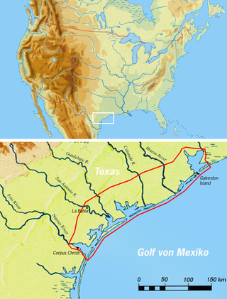
Lavaca Bay is a northwestern extension of the Matagorda Bay system found mostly in Calhoun County, Texas, United States. The ports of Port Lavaca and Point Comfort have been established on the bay, and are the main areas of human habitation. Linnville was located on the bay until its abandonment after the Great Raid of 1840, and the major port of Indianola was found near the confluence with the main Matagorda Bay, until the town's final destruction following the massive hurricane of 1886. Smaller communities include Olivia, Alamo Beach and Magnolia Beach. Lavaca Bay is approximately 82 miles (130 km) northeast of Corpus Christi, about 121 miles (190 km) southwest of Houston, and 145 miles (230 km) southeast of San Antonio.

<span class="mw-page-title-main">Matagorda Bay</span> Bay on the Texas coast, United States of America

Matagorda Bay is a large Gulf of Mexico bay on the Texas coast, lying in Calhoun and Matagorda counties and located approximately 80 miles (130 km) northeast of Corpus Christi, 143 miles (230 km) east-southeast of San Antonio, 108 miles (174 km) south-southwest of Houston, and 167 miles (269 km) south-southeast of Austin. It is one of seven major estuaries along the Gulf Coast of Texas and serves as the mouth of numerous streams, most notably the Lavaca and Colorado Rivers. The Texas seaport of Port Lavaca is located on the system's northwestern extension of Lavaca Bay. The city of Palacios is found on northeastern extension of Tres Palacios Bay, and Port O'Connor is located on the southwestern tip of the main bay's shore. The ghost town of Indianola, which was a major port before it was destroyed by two hurricanes in the late 19th century, is also found on the bay.

<span class="mw-page-title-main">Aransas Bay</span> Bay on the Gulf Coast in Texas, United States

Aransas Bay is a bay on the Texas Gulf Coast, approximately 30 miles (48 km) northeast of Corpus Christi, and 173 miles (278 km) south of San Antonio. It is separated from the Gulf of Mexico by San José Island. Aransas Pass is the most direct navigable outlet into the Gulf of Mexico from the bay. The cities of Aransas Pass and Port Aransas are located at the southern end, and Rockport is found on the central western shore. The bay is oriented laterally northeast–southwest, and is extended by Redfish Bay to the southwest, Copano Bay to the west, Saint Charles Bay to the north, and Mesquite Bay to the northeast. Aransas Bay is part of the Mission-Aransas National Estuarine Research Reserve.

<span class="mw-page-title-main">Corpus Christi Bay</span> Estuary bay on the Texas coast

Corpus Christi Bay is a scenic semi-tropical bay on the Texas coast found in San Patricio and Nueces counties, next to the major city of Corpus Christi. It is separated from the Gulf of Mexico by Mustang Island, and is fed by the Nueces River and Oso Creek from its western and southern extensions, Nueces Bay and Oso Bay. The bay is located approximately 136 miles (219 km) south of San Antonio, and 179 miles (288 km) southwest of Houston.

<span class="mw-page-title-main">San Antonio Bay</span> Estuary bay on the Texas coast

San Antonio Bay is a bay on the Texas Gulf Coast situated between Matagorda and Aransas Bay. It consists mainly of the combined waters of the San Antonio and Guadalupe rivers, and is located at the mouth of the Guadalupe River, about 55 miles (89 km) northeast of Corpus Christi and 130 miles (209 km) southeast of San Antonio. It is protected from the Gulf of Mexico by Matagorda Island, leaving only relatively small and distant outlets to the Gulf for little mixing of bay and Gulf waters. The remoteness of the bay has prevented the establishment of major ports as seen on Aransas Bay and Corpus Christi Bay, to the south.

<span class="mw-page-title-main">Nueces Bay</span> Bay in Texas, United States

Nueces Bay is a northwestern extension of Corpus Christi Bay in the San Patricio and Nueces Counties of Texas. The bay is fed by the Nueces River, forming a natural estuary, which renders it ecologically and economically vital to the surrounding area. It serves as a habitat for the propagation of fish and shellfish, which sustain diverse species of birds and other wildlife. The bay is threatened by pollution from the heavy industry on its southern shore, which prevents oyster farming. Petrochemical production and oil are important to the surrounding economies of the major settlements of Corpus Christi and Portland, found on the eastern shore and connected by the Nueces Bay Causeway at the bay's confluence with Corpus Christi Bay.

Holiday Beach is an unincorporated community and census-designated place in Aransas County, Texas, United States. As of the 2010 census it had a population of 514. This was a new CDP for the 2010 census.

<span class="mw-page-title-main">History of the Galveston Bay Area</span> Aspect of history surrounding the Galveston Bay Area

For a period of over 7000 years, humans have inhabited the Galveston Bay Area in what is now the United States. Through their history the communities in the region have been influenced by the once competing sister cities of Houston and Galveston, but still have their own distinct history. Though never truly a single, unified community, the histories of the Bay Area communities have had many common threads.

St. Charles Bay is an inlet of Aransas Bay in Aransas County, Texas. It is flanked by Lamar peninsula on the west and Blackjack peninsula on the east. The bay hosts a valued ecosystem for the endangered whooping crane, and is a prime location for birding and fishing. Goose Island State Park and the Aransas National Wildlife Refuge are located along the bay's shores, attracting nature enthusiasts year-round.

<span class="mw-page-title-main">Laguna Madre (United States)</span> Hypersaline lagoon in Texas, US

The Laguna Madre is a long, shallow, hypersaline lagoon along the western coast of the Gulf of Mexico in Nueces, Kenedy, Kleberg, Willacy and Cameron Counties in Texas, United States. It is one of seven major estuaries along the Gulf Coast of Texas. The roughly 20-mile (32 km) long Saltillo Flats land bridge divides it into Upper and Lower lagoons joined by the Intracoastal Waterway, which has been dredged through the lagoon. Cumulatively, Laguna Madre is approximately 130 miles (210 km) long, the length of Padre Island in the US. The main extensions include Baffin Bay in Upper Laguna Madre, Red Fish Bay just below the Saltillo Flats, and South Bay near the Mexican border. As a natural ecological unit, the Laguna Madre of the United States is the northern half of the ecosystem as a whole, which extends into Tamaulipas, Mexico approximately 144 miles (232 km) south of the US border, to the vicinity of the Rio Soto La Marina and the town of La Pesca, extending approximately 275 miles (443 km) through USA and Mexico in total.

<span class="mw-page-title-main">Carancahua Bay</span> American bay

Carancahua Bay is a northern extension of Matagorda Bay located in Jackson and Matagorda counties in Texas, United States. It is oriented from the southeast to the northwest but meanders as it reaches the north to the confluence with Carancahua Creek. Generally slender, it is only about 1 mile (1.6 km) in width north of its circular mouth.

<span class="mw-page-title-main">East Bay (Texas)</span>

East Bay also known as East Galveston Bay, is the eastern extension of Galveston Bay found in Chambers County, Texas. The bay is oriented northeast to southwest, and is approximately five miles wide and twenty miles in length. It covers the area north of the entire Bolivar Peninsula, and south of mainland Texas, including the small community of Smith Point at the western extreme. The bay's one extension is Rollover Bay, which is found to the extreme east near the town of Gilchrist.

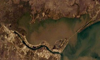
Copano is a ghost town on the northwestern shore of Copano Bay in Refugio County, Texas. It is located 5 mi (8.0 km) north of present-day Bayside, on Copano Point. The port, which holds the distinction as the first in South Texas, was founded in the early 18th century by the Spanish, and named for the Copane Indians who resided in the area. Initially, it was used as a port by smugglers and pirates, until 1785, when it was officially opened for use by the Spanish empire. The port was abandoned in the 1880s, following the settlement of the area after the Texas Revolution. Ruins of the town site can still be found, but are currently in danger of falling into Copano Bay.

Aransas City is a ghost town on the tip of the Live Oak Peninsula in Aransas County, Texas near present-day Fulton. It served as a port on Aransas Bay at its confluence with Copano Bay during the 1830s and 1840s, but declined following its loss of a Republic of Texas customhouse to the rival port of Lamar.

St. Mary's of Aransas is a ghost town near the present community of Bayside in Refugio County, Texas, United States. It served as a settlement and major port until the emergence of Rockport in the late 19th century.

James Power was an Irish-born Texan empresario, politician and signer of the Texas Declaration of Independence, known for the land grant he received with partner James Hewetson that included the coastal area between the mouths of the Guadalupe and Nueces Rivers, as well as his founding and service as the first mayor of the Aransas City settlement. He often represented Refugio County during statewide conventions. Was part of the Mexican national era

<span class="mw-page-title-main">Estuaries of Texas</span> Estuaries on the Gulf coast of Texas

The U.S. state of Texas has a series of estuaries along its coast on the Gulf of Mexico, most of them bounded by the Texas barrier islands. Estuaries are coastal bodies of water in which freshwater from rivers mixes with saltwater from the sea. Twenty-one drainage basins terminate along the Texas coastline, forming a chain of seven major and five minor estuaries: listed from southwest to northeast, these are the Rio Grande Estuary, Laguna Madre, the Nueces Estuary, the Mission–Aransas Estuary, the Guadalupe Estuary, the Colorado–Lavaca Estuary, East Matagorda Bay, the San Bernard River and Cedar Lakes Estuary, the Brazos River Estuary, Christmas Bay, the Trinity–San Jacinto Estuary, and the Sabine–Neches Estuary. Each estuary is named for its one or two chief contributing rivers, excepting Laguna Madre, East Matagorda Bay, and Christmas Bay, which have no major river sources. The estuaries are also sometimes referred to by the names of their respective primary or central water bodies, though each also includes smaller secondary bays, inlets, or other marginal water bodies.

<span class="mw-page-title-main">Copano people</span> Extinct Native American tribe from Texas

The Copano were a Native American sub-tribe of Karankawa peoples from Texas.

References

  1. Long, Christopher. "Aransas County". Handbook of Texas Online. Texas State Historical Association. Retrieved 5 July 2010.
  2. 1 2 3 "Copano Bay". Handbook of Texas Online . Texas State Historical Association. May 30, 2010. Retrieved 5 July 2010.
  3. La Vere, David (2004). The Texas Indians . College Station: Texas A&M University Press. p.  59. ISBN   1-58544-301-8.
  4. Givens, Murphy (October 31, 2001). "A voyage out of time". Corpus Christi Caller-Times. Archived from the original on November 17, 2002. Retrieved 6 July 2010.
  5. Benowitz, June Melby. "Copano, Texas". Handbook of Texas Online. Texas State Historical Association. Retrieved 5 July 2010.
  6. Huson, Hobart (May 30, 2010). "St. Mary's of Aransas, Texas". Handbook of Texas Online. Texas State Historical Association. Retrieved 5 July 2010.
  7. Huson, Hobart (May 30, 2010). "Black Point, Texas". Handbook of Texas Online. Texas State Historical Association. Retrieved 5 July 2010.
  8. Benowitz, June Melby (May 30, 2010). "Bayside, Texas". Handbook of Texas Online. Texas State Historical Association. Retrieved 5 July 2010.
  9. Jasinski, Laurie E. "Copano Village, Texas". Handbook of Texas Online. Texas State Historical Association. Retrieved 5 July 2010.
  10. Jasinski, Laurie E. "Holiday Beach, Texas". Handbook of Texas Online. Texas State Historical Association. Retrieved 6 July 2010.
  11. 1 2 3 Blackburn, Jim (October 2004). The book of Texas bays. Texas A&M University Press. p. 205. ISBN   978-1-58544-339-0.
  12. 1 2 "Topographic Maps". Digital-Topo-Maps.com. Google. Retrieved 5 July 2010.
  13. 1 2 3 Tunnell, John W.; Andrews, Jean; Barrera, Noe C; Moretzsohn, Fabio (2010). Encyclopedia of Texas Seashells: Identification, Ecology, Distribution, and History. Texas A&M University Press. pp. 32, 263. ISBN   978-1-60344-141-4.
  14. Scates, Chuck; Phil H. Shook. "Fly Fishing the Texas Coast - Copano Bay". Great Outdoor Recreation Pages. Archived from the original on 19 December 2009. Retrieved 6 July 2010.
  15. "Copano Bay". Gulf Base. Harte Research Institute for Gulf of Mexico Studies. Archived from the original on 24 September 2010. Retrieved 5 July 2010.
  16. Bowen, Greg (December 10, 2003). "Grant will help fund wetlands project". The Victoria Advocate.
  17. "Trucks used to clean up crude oil". The Victoria Advocate. May 14, 1997.
  18. "Recreational Fishing: Shrimp Regulations". Texas Parks and Wildlife Department. Retrieved 6 July 2010.

28°07′12″N97°06′38″W / 28.12000°N 97.11056°W / 28.12000; -97.11056