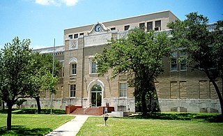
San Patricio County is a county in the U.S. state of Texas. As of the 2010 census, the population was 64,804. Its county seat is Sinton.

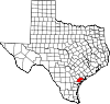
Nueces County is a county in the U.S. state of Texas. As of the 2010 census, the population was 340,223, making it the 14th-most populous county in the state. The county seat is Corpus Christi. The county was formed in 1846 from portions of San Patricio County and organized the following year. It is named for the Nueces River, which marks the county's northwestern boundary with San Patricio County before emptying into its mouth at Nueces Bay north of the port of Corpus Christi. Nueces County is part of the Corpus Christi metropolitan statistical area.

Aransas County is a county located in the U.S. state of Texas. As of the 2010 census, the population was 23,158. Its county seat is Rockport. The county was formed in 1871 from Refugio County and organized the following year. It was named for the Rio Nuestra Senora de Aranzazu, a Spanish outpost in early Texas.
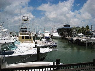
Port Aransas is a city in Nueces County, Texas, United States. This city is 180 miles southeast of San Antonio. The population was 3,480 at the 2010 census. Port Aransas is the only established town on Mustang Island. It is located north of Padre Island and is one of the longest barrier islands along the Texas coast. Corpus Christi Bay, the Gulf of Mexico, the Lydia Ann Ship Channel and the Corpus Christi Ship Channel make up the surrounding waters.

Aransas Pass is a city in Aransas, Nueces, and San Patricio Counties in the U.S. state of Texas. The population was 8,204 at the 2010 Census.

The Nueces River is a river in the U.S. state of Texas, about 315 miles (507 km) long. It drains a region in central and southern Texas southeastward into the Gulf of Mexico. It is the southernmost major river in Texas northeast of the Rio Grande. Nueces is Spanish for nuts; early settlers named the river after the numerous pecan trees along its banks.

South Texas is a region of the U.S. state of Texas that lies roughly south of—and including—San Antonio. The southern and western boundary is the Rio Grande, and to the east it is the Gulf of Mexico. The population of this region is about 4.96 million according to the 2017 census estimates. The southern portion of this region is often referred to as the Rio Grande Valley. The eastern portion along the Gulf of Mexico is also referred to as the Coastal Bend.

Aransas Pass is a navigable salt water channel connecting the Gulf of Mexico with Aransas Bay on the Texas Gulf coast in the United States. The pass separates Mustang Island to the south from San José Island to the north, and is protected by jetties extending into the Gulf from both islands. At the eastern end of the pass is the town of Port Aransas, located at the far northern end of Mustang Island. At the western end of the pass, on the mainland side of Aransas Bay, is the town of Aransas Pass. A free ferry serves the two towns. The pass is located on the Aransas County and Nueces County line.

Matagorda Island, Spanish for "thick brush," is a 38-mile (61 km) long barrier island on the Texas Gulf coast, located approximately seven miles south of Port O'Connor, in the southernmost part of Calhoun County. The traditional homeland of the Karankawa people, the island is oriented generally northeast-southwest, with the Gulf of Mexico on the east and south, and Espiritu Santo Bay on the west and north. It is separated from San José Island to the south by Cedar Bayou, and is separated from the Matagorda Peninsula to the north by Pass Cavallo. It is accessible by boat only. It has a land area of 157.25 square kilometers.
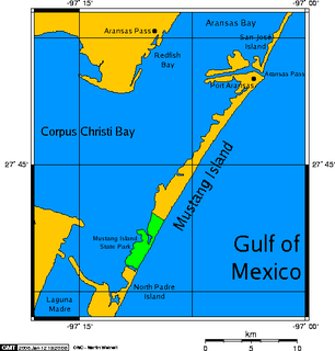
Mustang Island is a barrier island on the Gulf Coast of Texas in the United States. The island is 18 miles (29 km) long, stretching from Corpus Christi to Port Aransas. The island is oriented generally northeast–southwest, with the Gulf of Mexico on the east and south, and Corpus Christi Bay on the north and west. The island's southern end connects by roadway to Padre Island. At the northern end of the island is Port Aransas, beyond which is San José Island. The Aransas Channel, also known as the "Aransas Pass," which separates Mustang Island from San José Island, is protected by jetties extending into the Gulf from each island.

Aransas Bay is a bay on the Texas Gulf Coast, approximately 30 miles (48 km) northeast of Corpus Christi, and 173 miles (278 km) south of San Antonio. It is separated from the Gulf of Mexico by San José Island. Aransas Pass is the most direct navigable outlet into the Gulf of Mexico from the bay. The cities of Aransas Pass and Port Aransas are located at the southern end, and Rockport is found on the central western shore. The bay is oriented laterally northeast-southwest, and is extended by Redfish Bay to the southwest, Copano Bay to the west, Saint Charles Bay to the north, and Mesquite Bay to the northeast. Aransas Bay is part of the Mission-Aransas National Estuarine Research Reserve.
The Texas Coastal Bend, or just the Coastal Bend, is a geographical region in the US state of Texas. The name refers to the area being a curve along the coast of the Gulf of Mexico. The largest city of the Coastal Bend is Corpus Christi. It includes the Nueces Estuary and the Mission–Aransas Estuary, as well as part of Laguna Madre. The coastline is paralleled by several of the Texas barrier islands, including North Padre Island, Mustang Island, and San José Island.

San Antonio Bay is a bay on the Texas Gulf Coast situated between Matagorda and Aransas Bay. It consists mainly of the combined waters of the San Antonio and Guadalupe rivers, and is located at the mouth of the Guadalupe River, about 55 miles (89 km) northeast of Corpus Christi and 130 miles (209 km) southeast of San Antonio. It is protected from the Gulf of Mexico by Matagorda Island, leaving only relatively small and distant outlets to the Gulf for little mixing of bay and Gulf waters. The remoteness of the bay has prevented the establishment of major ports as seen on Aransas Bay and Corpus Christi Bay, to the south.

Copano Bay is a northwestern extension of Aransas Bay, west of Rockport, Texas in Refugio and Aransas counties. It is supplied with seawater from the Gulf of Mexico via Aransas Bay, and fed freshwater from the Aransas River, Mission River and Copano Creek. As an estuary, the bay is home to a diverse ecosystem consisting of various birds including the endangered whooping crane, and numerous finfish including the redfish as well as shellfish such as oysters. It is classified as a nursery for shrimp, which prohibits production from the bay. Copano Bay is also a historic location for human usage and settlement that dates back to the 18th century, beginning with the historic port of El Copano and the 19th century settlements of St. Mary's of Aransas and Copano. The present-day towns of Bayside, Copano Village and Holiday Beach were all founded in the 20th century. Oil and natural gas are pumped from below the bay's surface, and contribute to the livelihood of the local economies. Recently, areas around the bay were affected by Hurricane Harvey which crossed over the bay as a Category 3 hurricane.

Mustang Island State Park is a state park located south of the city of Port Aransas, Texas, United States on the coast of the Gulf of Mexico that covers 3,954 acres (1,600 ha) and has a 5-mile (8.0 km) beachfront. The land was acquired from private owners in 1972 and opened to the public in 1979. The island takes its name from wild mustangs that roamed the island which eventually succumbed to ranching in the late 1800s.
Cedar Bayou is a salt water channel on the Texas coast that separates San Jose Island from Matagorda Island. The pass serves as a water exchange between the Gulf of Mexico and the San Antonio, Matagorda and Aransas Bay systems.
The Mission-Aransas National Estuarine Research Reserve is a large contiguous complex of wetland, terrestrial, and marine environments on the Texas Coastal Bend in the United States. Named for the two major rivers that flow into the area, the reserve contains public and private lands and waters. The land is primarily coastal prairie with unique oak motte habitats. The wetlands include riparian habitat, freshwater marshes, and saltwater marshes. Within the water areas, the bays are large, open, and include extensive tidal flats, seagrass meadows, mangroves, and oyster reefs. These unique and diverse estuarine habitats in the western Gulf of Mexico support a host of endangered and threatened species including the endangered whooping crane.

St. Charles Bay is an inlet of Aransas Bay in Aransas County, Texas. It is flanked by Lamar peninsula on the west and Blackjack peninsula on the east. The bay hosts a valued ecosystem for the endangered whooping crane, and is a prime location for birding and fishing. Goose Island State Park and the Aransas National Wildlife Refuge are located along the bay's shores, attracting nature enthusiasts year-round.
The San Antonio and Aransas Pass Railway first began operation in the U.S. state of Texas in 1886. It was developed by Uriah Lott and businessmen of San Antonio as a direct route from the city to Aransas Bay on the Texas Gulf coast. It was eventually absorbed in the 20th century by Southern Pacific.

The U.S. state of Texas has a series of estuaries along its coast on the Gulf of Mexico, most of them bounded by the Texas barrier islands. Estuaries are coastal bodies of water in which freshwater from rivers mixes with saltwater from the sea. Twenty-one drainage basins terminate along the Texas coastline, forming a chain of seven major and five minor estuaries: listed from southwest to northeast, these are the Rio Grande Estuary, Laguna Madre, the Nueces Estuary, the Mission–Aransas Estuary, the Guadalupe Estuary, the Colorado–Lavaca Estuary, East Matagorda Bay, the San Bernard River and Cedar Lakes Estuary, the Brazos River Estuary, Christmas Bay, the Trinity–San Jacinto Estuary, and the Sabine–Neches Estuary. Each estuary is named for its one or two chief contributing rivers, excepting Laguna Madre, East Matagorda Bay, and Christmas Bay, which have no major river sources. The estuaries are also sometimes referred to by the names of their respective primary or central water bodies, though each also includes smaller secondary bays, inlets, or other marginal water bodies.