Brazos Santiago Pass (Texas)

Last updated

Brazos Santiago Pass
Chart, Point Isabel-Brazos Santiago - NARA - 87201507.jpg
Coast Survey of Brazos Santiago Pass ca. 1867 [1]
Brazos Santiago Pass Texas.jpg
Illustration of Brazos Santiago Pass
Relief map of Texas.png
Red pog.svg
Location on Texas Gulf Seacoast
Usa edcp relief location map.png
Red pog.svg
Brazos Santiago Pass (Texas) (the United States)
Location
CountryUnited States
Coordinates 26°03′56″N97°09′31″W / 26.06563°N 97.15858°W / 26.06563; -97.15858 (Brazos Santiago Pass)
Specifications
Length1.14 miles (1.83 km)
NOAA NDBC Brazos Santiago ~ BZST2
History
Former names
  • Brazos Island Harbor Channel
  • Brownsville Channel
  • Port Isabel Channel
Modern nameBrazos Santiago Inlet
Current ownerState of Texas
Geography
DirectionWest
Start point Gulf of Mexico
End pointPort Isabel
Beginning coordinates 26°03′59″N97°08′42″W / 26.06631°N 97.14496°W / 26.06631; -97.14496 (Brazos Santiago Pass Entrance)
Ending coordinates 26°03′59″N97°09′50″W / 26.06632°N 97.16395°W / 26.06632; -97.16395 (Brazos Santiago Pass Exit)
Branch(es)Laguna Madre
Branch of
  • Lower Laguna Madre
  • Lower Rio Grande Valley
Connects to
GNIS feature ID 1372708

Brazos Santiago Pass is a natural coastal landform located in the Lower Laguna Madre and Lower Rio Grande Valley on the furthest southern beach terrain of the Texas Gulf Coast. [2] The seacoast passage is interpolated by barrier islands encompassing the southern Brazos Island and the northern South Padre Island. [3]

Contents

Jetties at Brazos Santiago Pass Brazos Santiago Pass Jetty Texas.jpg
Jetties at Brazos Santiago Pass

The waterway inlet is a navigable strait spanning a water depth of 42 feet (13 m) and a waterway channel distance of 1.14 miles (1.83 km). The Brazos Santiago channel and seaward approach is defined by parallel jetties designed with a breakwater separation of .25 miles (0.40 km). The jetty harbor development sustains the passage entrance from coastal erosion, coastal sediment transport, longshore drift, and sandbank shoals. The South Padre Island jetty is .6 miles (0.97 km) from the Padre Island shoreline annexed by the Boca Chica jetty extending .3 miles (0.48 km) into the Brazos Island continental margin.

The natural ocean inlet has a shoreline distance on Brazos Island of 7.5 miles (12.1 km) to the Rio Grande often entitled as the Mexico–United States border.

In 1850, the 31st United States Congress authorized the Lighthouse Service Act as enacted into law by 13th President of the United States Millard Fillmore on September 28, 1850. [4] In 1851, the United States Lighthouse Board was convened as a quasi-military board fostering guardianship as applicable toterrestrial navigation services for maritime transport by the United States Lighthouse Service.

Screw-pile lighthouse in Laguna Madre Light House on Padre Island, Across the bay from Point Isabel (NBY 3319).jpg
Screw-pile lighthouse in Laguna Madre

In 1853, a nautical beacon was initially established on South Padre Island with a proximity to the Brazos Island Military Depot originally entitled Fort Polk during the Mexican–American War. [6] [7] [8] The navigation beacon had a 30 feet (9.1 m) vertical height situated on a square platform with a 15 feet (4.6 m) width. The structural design was constructed of wood equipped with a square copper lantern hoisted by block and tackle to the pinnacle. The beacon was visually completed with 5 feet (1.5 m) artillery wheels secured to a 19 feet (5.8 m) oak axletree for to and fro mobility on the barrier island coastline. [9]

In 1879, a screw-pile lighthouse was established in the intertidal zone of the Lower Laguna Madre with a geographic proximity to the Brazos Santiago Pass. [10] The deep foundation architecture was acknowledged as a notable landmark sight for sixty years within the Texas international boundary region of the Lower Rio Grande Valley coast. [11] [12] The foundation was developed with screw piles anchored into the estuarial seabed of the Lower Laguna Madre. [13] [14] [15] The upper quarters were structured as a 1½ storey hexagonal Cape Cod style cottage built of timbers completed with a fourth-order fresnel lens located at the pinnacle. [16] [17]

The stilt structure had a visibility from the brackish water bearing 150 yards (140 m) from the South Padre Island shore and 750 yards (690 m) from the Brazos Santiago Pass. [18] [19]

Locale of Brazos Santiago Pass Screw-Pile Lighthouse
Brazos Santiago Pass (Texas)
Brazos Santiago screw-pile lighthouse

US coastal navigability development of Brazos Santiago pass

The Rivers and Harbors Act established a declaration of governance for the natural waterway of the Brazos Santiago Pass. The Act of Congress granted coastal engineering, coastal management, and public works projects for the natural inland waterway during the late nineteenth century to the twentieth century.

The Brazos Island and South Padre Island landform development proposals were endorsed by the United States Army Corps of Engineers sustaining the beach evolution at the Brazos Island Harbor natural inlet. [20] [21] [22]

U.S. Statutes for Navigable Waterway Development at Brazos Santiago Pass
Date of EnactmentPublic LawU.S. StatuteU.S. Statute Title
◇ June 18, 1878P.L. 45-26420  Stat.   152 Rivers and Harbors Act of 1878
◇ June 14, 1880P.L. 46-21121  Stat.   180 Rivers and Harbors Act of 1880
◇ March 3, 1881P.L. 46-13621  Stat.   468 Rivers and Harbors Act of 1881
◇ Angust 2, 1882P.L. 47-37522  Stat.   191 Rivers and Harbors Act of 1882
◇ July 5, 1884P.L. 48-22923  Stat.   133 Rivers and Harbors Act of 1884
◇ August 5, 1886P.L. 49-92924  Stat.   310 Rivers and Harbors Act of 1886
◇ August 11, 1888P.L. 50-86025  Stat.   400 Rivers and Harbors Act of 1888
◇ August 18, 1894P.L. 53-29928  Stat.   338 Rivers and Harbors Act of 1894
◇ March 3, 1899P.L. 55-42530  Stat.   1121 Rivers and Harbors Act of 1899
◇ March 3, 1909P.L. 60-31735  Stat.   815 Rivers and Harbors Act of 1909
◇ July 25, 1912P.L. 62-24137  Stat.   201 Rivers and Harbors Act of 1912
◇ March 2, 1919P.L. 65-32340  Stat.   1275 Rivers and Harbors Act of 1919
◇ March 3, 1925P.L. 68-58543  Stat.   1186 Rivers and Harbors Act of 1925
◇ July 3, 1930P.L. 71-52046  Stat.   918 Rivers and Harbors Act of 1930
◇ August 30, 1935P.L. 74-40949  Stat.   1028 Rivers and Harbors Act of 1935
◇ March 2, 1945P.L. 79-1459  Stat.   10 Rivers and Harbors Act of 1945
◇ May 17, 1950P.L. 81-51664  Stat.   163 Rivers and Harbors Act of 1950
◇ July 14, 1960P.L. 86-64574  Stat.   480 Rivers and Harbors Act of 1960

Station Brazos and US Life Saving Service

In 1878, the United States Life Saving Service Act authorized the creation of a coastal life saving station near the navigable strait of the Brazos Island Harbor. [23] The Station Brazos was constructed in 1881 and governed by the United States Life-Saving Service. [24]

Texas Historical Commission site

The Brazos Santiago Pass received a historical marker in 1996 by the Texas Historical Commission establishing a momentous narrative for the south Texas coastal dominion during the nineteenth century. [25]

See also

Related Research Articles

<span class="mw-page-title-main">Padre Island National Seashore</span> Protected area

Padre Island National Seashore (PINS) is a national seashore located on Padre Island off the coast of South Texas. In contrast to South Padre Island, known for its beaches and vacationing college students, PINS is located on the north end of Padre Island and consists of a long beach where nature is preserved.

<span class="mw-page-title-main">College Station, Texas</span> City in Texas, United States

College Station is a city in Brazos County, Texas, United States, situated in East-Central Texas in the Brazos Valley, towards the eastern edge of the region known as the Texas Triangle. It is 83 miles northwest of Houston and 87 miles (140 km) east-northeast of Austin. As of the 2020 census, College Station had a population of 120,511. College Station and Bryan make up the Bryan-College Station metropolitan area, the 15th-largest metropolitan area in Texas with 268,248 people as of 2020.

<span class="mw-page-title-main">Port Isabel, Texas</span> City in Texas, United States

Port Isabel is a city in Cameron County, Texas, United States. It is part of the Brownsville–Harlingen–Raymondville and the Matamoros–Brownsville metropolitan areas. The population was 5,006 at the 2010 census.

<span class="mw-page-title-main">South Padre Island, Texas</span> Town in Texas, United States

South Padre Island is a resort town in Cameron County, Texas, United States. It is part of the Brownsville–Harlingen Metropolitan Statistical Area. The population was 2,066 at the 2020 census. The town is located on South Padre Island, a barrier island with the Laguna Madre situated to the leeward of the island and the Gulf of Mexico on the windward flank, along the Texas Gulf Coast. South Padre Island is accessible via the Queen Isabella Causeway from the town of Port Isabel. South Padre Island is named after José Nicolás Ballí, a Catholic priest and settler.

<span class="mw-page-title-main">Knights of Pythias</span> Fraternal service organization

The Knights of Pythias is a fraternal organization and secret society founded in Washington, D.C., on February 19, 1864. The Knights of Pythias is the first fraternal organization to receive a charter under an act of the United States Congress.

<span class="mw-page-title-main">Padre Island</span> Barrier island in southern Texas

Padre Island is the largest of the Texas barrier islands and the world's longest barrier island. The island is located along Texas's southern coast of the Gulf of Mexico and is noted for its white sandy beaches. Meaning father in Spanish, it was named after Father José Nicolás Ballí (c.1770-1829), who owned the island and served as a missionary priest and collector of finances for all the churches in the Rio Grande Valley. He also founded the first mission in present-day Cameron County.

<span class="mw-page-title-main">Western Gulf coastal grasslands</span> Subtropical grassland ecoregion of Mexico and the United States

The Western Gulf coastal grasslands are a subtropical grassland ecoregion of the southern United States and northeastern Mexico. It is known in Louisiana as the "Cajun Prairie", Texas as "Coastal Prairie," and as the Tamaulipan pastizal in Mexico.

<span class="mw-page-title-main">Lighthouse keeper</span> Profession in the shipping industry

A lighthouse keeper or lightkeeper is a person responsible for tending and caring for a lighthouse, particularly the light and lens in the days when oil lamps and clockwork mechanisms were used. Lighthouse keepers were sometimes referred to as "wickies" because of their job trimming the wicks.

<span class="mw-page-title-main">Sirri Island</span> Lighthouse

Sirri Island, is an island in the Persian Gulf belonging to Iran.

<span class="mw-page-title-main">South Bay (Texas)</span>

South Bay is a bay in the Laguna Madre in Texas separated from the Gulf of Mexico by Brazos Island. It is the southernmost bay in Texas, about 1 mi (1.6 km) north of the Texas-Mexico Border.

The John F. Kennedy Memorial Causeway is a paved highway located in Corpus Christi, Texas. The causeway crosses the Laguna Madre and connects North Padre Island with Flour Bluff on the Texas mainland.

<span class="mw-page-title-main">Bird Island Light</span> Lighthouse

Bird Island Light is a historic lighthouse at the entrance to Sippican Harbor in Marion, Massachusetts. Built in 1819, its tower is a well-preserved example of an early 19th-century masonry lighthouse. The tower and the island on which it stands were added to the National Register of Historic Places as Bird Island Light on September 28, 1987.

<span class="mw-page-title-main">Point Isabel Light</span> Historic lighthouse located in Port Isabel, Texas, United States

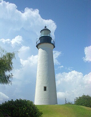
The Point (Port) Isabel Lighthouse is a historic lighthouse located in Port Isabel, Texas, United States that was built in 1852 to guide ships through the Brazos Santiago Pass to Port Isabel. The lighthouse was added to the National Register of Historic Places on April 30, 1976.

The Port of Brownsville is a deep water seaport in Brownsville, at the southern tip of Texas.

<span class="mw-page-title-main">Laguna Madre (United States)</span> Hypersaline lagoon in Texas, US

The Laguna Madre is a long, shallow, hypersaline lagoon along the western coast of the Gulf of Mexico in Nueces, Kenedy, Kleberg, Willacy and Cameron Counties in Texas, United States. It is one of seven major estuaries along the Gulf Coast of Texas. The roughly 20-mile (32 km) long Saltillo Flats land bridge divides it into Upper and Lower lagoons joined by the Intracoastal Waterway, which has been dredged through the lagoon. Cumulatively, Laguna Madre is approximately 130 miles (210 km) long, the length of Padre Island in the US. The main extensions include Baffin Bay in Upper Laguna Madre, Red Fish Bay just below the Saltillo Flats, and South Bay near the Mexican border. As a natural ecological unit, the Laguna Madre of the United States is the northern half of the ecosystem as a whole, which extends into Tamaulipas, Mexico approximately 144 miles (232 km) south of the US border, to the vicinity of the Rio Soto La Marina and the town of La Pesca, extending approximately 275 miles (443 km) through USA and Mexico in total.

<span class="mw-page-title-main">1874 Atlantic hurricane season</span> Hurricane season in the Atlantic Ocean

The 1874 Atlantic hurricane season was a relatively inactive one, in which seven tropical cyclones developed. Four storms intensified into hurricanes, but none attained major hurricane status. However, in the absence of modern satellite and other remote-sensing technologies, only storms that affected populated land areas or encountered ships at sea were recorded, so the actual total could be higher. An undercount bias of zero to six tropical cyclones per year between 1851 and 1885 and zero to four per year between 1886 and 1910 has been estimated.

<span class="mw-page-title-main">Brazos Island</span> Island in the United States of America

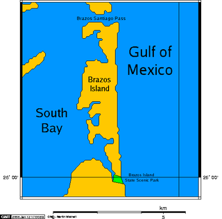
Brazos Island, also known as Brazos Santiago Island, is a barrier island on the Gulf Coast of Texas in the United States, south of the town of South Padre Island. The island is located in Cameron County.

<span class="mw-page-title-main">Coast Guard Station South Padre Island</span> US Coast Guard station in Texas

United States Coast Guard Station South Padre Island is a large United States Coast Guard station six miles (9.7 km) north of the Mexico–United States border in South Padre Island, Texas. The station is home to the Aids to Navigation Team (ANT) South Padre Island and the cutter USCGC Alligator (WPB-87372). It focuses on search and rescue and maritime law enforcement. It belongs to the United States Coast Guard 8th District Sector Corpus Christi.

<span class="mw-page-title-main">Estuaries of Texas</span> Estuaries on the Gulf coast of Texas

The U.S. state of Texas has a series of estuaries along its coast on the Gulf of Mexico, most of them bounded by the Texas barrier islands. Estuaries are coastal bodies of water in which freshwater from rivers mixes with saltwater from the sea. Twenty-one drainage basins terminate along the Texas coastline, forming a chain of seven major and five minor estuaries: listed from southwest to northeast, these are the Rio Grande Estuary, Laguna Madre, the Nueces Estuary, the Mission–Aransas Estuary, the Guadalupe Estuary, the Colorado–Lavaca Estuary, East Matagorda Bay, the San Bernard River and Cedar Lakes Estuary, the Brazos River Estuary, Christmas Bay, the Trinity–San Jacinto Estuary, and the Sabine–Neches Estuary. Each estuary is named for its one or two chief contributing rivers, excepting Laguna Madre, East Matagorda Bay, and Christmas Bay, which have no major river sources. The estuaries are also sometimes referred to by the names of their respective primary or central water bodies, though each also includes smaller secondary bays, inlets, or other marginal water bodies.

<span class="mw-page-title-main">Port Mansfield Channel</span> Artificial water inlet in Texas, United States

Port Mansfield Channel or Mansfield Cut is an artificial waterway encompassing the Laguna Madre positioned at the 97th meridian west on the earth's longest barrier island known as Padre Island. During Post–World War II, the tidal inlet was dredged as a private channel differentiating North Padre Island better known as Padre Island National Seashore and South Padre Island. The navigable waterway was channeled during the late 1950s ceremoniously cresting the intertidal zone of the Gulf of Mexico by September 1957 on the Texas Gulf Coast.

References

  1. "Brazos Santiago". Texas Almanac . Texas State Historical Association (TSHA).
  2. Brazos Santiago Pass in Geonames.org (cc-by)
  3. Anonymous. "Brazos Santiago Pass". Handbook of Texas Online. Texas State Historical Association.
  4. "Lighthouse Service Act of 1850 – P.L. 31-77" (PDF). 9 Stat. 500 ~ Chapter 77. USLaw.Link. September 28, 1850.
  5. "Brazos Santiago – Lighthouse Postcard". J. Candace Clifford Lighthouse Research Catalog. United States Lighthouse Society. 1916. Archived from the original on July 6, 2021.
  6. "Notice to Mariners ~ The Sailor's Magazine, Vol. 25, No. 9" [Brazos Pass Beacon and Padre Island Light Observations ~ Notice to Mariners ]. HathiTrust Digital Library. American Seamen's Friend Society. May 1853. p. 280.
  7. "Notice to Mariners ~ The Sailor's Magazine, Vol. 25, No. 11" [Brazos Pass Beacon and Padre Island Light Observations ~ Notice to Mariners ]. HathiTrust Digital Library. American Seamen's Friend Society. July 1853. p. 344.
  8. Rozeff, Norman. "Fort Polk". Handbook of Texas Online. Texas State Historical Association.
  9. "COMMENTS ~ Brazos Santiago Pass Light Station". J. Candace Clifford Lighthouse Research Catalog. United States Lighthouse Society. 1879.
  10. "Brazos Santiago Light List Illustrations ~ 1892, 1895, 1900". J. Candace Clifford Lighthouse Research Catalog. United States Lighthouse Society. 1892. Archived from the original on October 8, 2022. Retrieved October 8, 2022.{{cite web}}: CS1 maint: bot: original URL status unknown (link)
  11. "Brazos Santiago Pass Lights". J. Candace Clifford Lighthouse Research Catalog. United States Lighthouse Society. 1879. Archived from the original on October 8, 2022. Retrieved October 8, 2022.{{cite web}}: CS1 maint: bot: original URL status unknown (link)
  12. "Brazos Santiago Lighthouse". U.S. Coast Guard Historic Topics. United States Coast Guard.
  13. "Brazos Santiago – Plate 2 Foundation Screw, Castings". J. Candace Clifford Lighthouse Research Catalog. United States Lighthouse Society. November 15, 1877. Archived from the original on October 8, 2022. Retrieved October 8, 2022.{{cite web}}: CS1 maint: bot: original URL status unknown (link)
  14. "Brazos Santiago – Plate 1 Elevation". J. Candace Clifford Lighthouse Research Catalog. United States Lighthouse Society. November 15, 1877. Archived from the original on October 8, 2022. Retrieved October 8, 2022.{{cite web}}: CS1 maint: bot: original URL status unknown (link)
  15. "Brazos Santiago – Elevation Plate with Handwritten Notations". J. Candace Clifford Lighthouse Research Catalog. United States Lighthouse Society. July 17, 1877. Archived from the original on October 8, 2022. Retrieved October 8, 2022.{{cite web}}: CS1 maint: bot: original URL status unknown (link)
  16. "Brazos Santiago – Plate 2 Sectional Elevation & Main Floor Timbers". J. Candace Clifford Lighthouse Research Catalog. United States Lighthouse Society. October 1877. Archived from the original on October 8, 2022. Retrieved October 8, 2022.{{cite web}}: CS1 maint: bot: original URL status unknown (link)
  17. "Brazos Santiago (Texas) ~ Historical Light List Specifications". U.S. Lighthouse Society Education. United States Lighthouse Society.
  18. "Brazos Santiago – Distance Aerial". J. Candace Clifford Lighthouse Research Catalog. United States Lighthouse Society. Archived from the original on October 8, 2022. Retrieved October 8, 2022.{{cite web}}: CS1 maint: bot: original URL status unknown (link)
  19. "Brazos Santiago – Aerial". J. Candace Clifford Lighthouse Research Catalog. United States Lighthouse Society. Archived from the original on October 8, 2022. Retrieved October 8, 2022.{{cite web}}: CS1 maint: bot: original URL status unknown (link)
  20. Rosati, Julie D. (June 2005). "DTIC ADA435162: Coastal Inlet Navigation Channel Shoaling with Deepening and Widening". Internet Archive. Defense Technical Information Center.
  21. U.S. Army Corps of Engineers (October 2015). "DTIC ADA624911: Shoaling Analysis at Brazos Island, Harbor Inlet, Texas". Internet Archive. Defense Technical Information Center.
  22. U.S. Army Engineer Research and Development Center (February 2018). "DTIC AD1047951: Brazos Santiago Inlet, Texas, Shoaling Study". Internet Archive. Defense Technical Information Center.
  23. "Life Saving Service Act of 1878 ~ P.L. 45-265" (PDF). 20 Stat. 163 ~ Chapter 265. USLaw.Link. June 18, 1878.
  24. "Station Brazos, Texas". USLSS Station No. 6, Eighth District ~ Coast Guard Station No. 222. United States Coast Guard.
  25. "Brazos Santiago Pass and Brazos Island Military Depot ~ Cameron County – Marker Number: 11777". Texas Historic Sites Atlas. Texas Historical Commission. 1996.

Marine archaeology bibliography