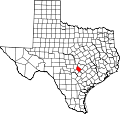
Williamson County is a county in the U.S. state of Texas. As of the 2020 census, its population was 609,017. Its county seat is Georgetown. The county is named for Robert McAlpin Williamson, a community leader and a veteran of the Battle of San Jacinto.

Travis County is located in Central Texas. As of the 2020 census, the population was 1,290,188. It is the fifth-most populous county in Texas. Its county seat and most populous city is Austin, the state's capital. The county was established in 1840 and is named in honor of William Barret Travis, the commander of the Republic of Texas forces at the Battle of the Alamo. Travis County is part of the Austin–Round Rock–Georgetown Metropolitan Statistical Area. It is located along the Balcones Fault, the boundary between the Edwards Plateau to the west and the Blackland Prairie to the east.

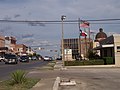
Boerne is a city in and the county seat of Kendall County, Texas, United States, in the Texas Hill Country. Boerne is known for its German-Texan history, named in honor of German author and satirist Ludwig Börne by the German Founders of the town. The population of Boerne was 10,471 at the 2010 census, and in 2020 the population was 17,850. The city is noted for the landmark U.S. Supreme Court case City of Boerne v. Flores. Founded in 1849 as "Tusculum", the name was changed to "Boerne" when the town was platted in 1852.
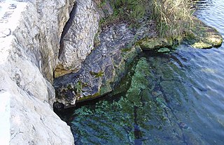
Barton Springs is a set of four natural water springs located at Barton Creek on the grounds of Zilker Park in Austin, Texas, resulting from water flowing through the Edwards Aquifer. The largest spring, Main Barton Spring, supplies water to Barton Springs Pool, a popular recreational destination in Austin. The smaller springs are located nearby, two with man-made structures built to contain and direct their flow. The springs are the only known habitat of the Barton Springs Salamander, an endangered species.

The Texas Hill Country is a geographic region of Central and South Texas, forming the southeast part of the Edwards Plateau. Given its location, climate, terrain, and vegetation, the Hill Country can be considered the border between the American Southeast and Southwest. The region represents the very remote rural countryside of Central Texas, but also is home to growing suburban neighborhoods and affluent retirement communities.

The Balcones Fault or Balcones Fault Zone is an area of largely normal faulting in the U.S. state of Texas that runs roughly from the southwest part of the state near Del Rio to the north-central region near Dallas along Interstate 35. The Balcones Fault zone is made up of many smaller features, including normal faults, grabens, and horsts. One of the obvious features is the Mount Bonnell Fault.

The Edwards Plateau is a geographic region forming the crossroads of Central, South and West Texas, United States. It is named in honor of Haden Edwards. It is bounded by the Balcones Fault to the south and east; the Llano Uplift and the Llano Estacado to the north; and the Pecos River and Chihuahuan Desert to the west. San Angelo, Austin, San Antonio and Del Rio roughly outline the area. The plateau, especially its southeast portion, is also known as the Texas Hill Country.

Mount Bonnell, also known as Covert Park, is a prominent point alongside the Lake Austin portion of the Colorado River in Austin, Texas. It has been a popular tourist destination since the 1850s. The mount provides a vista for viewing the city of Austin, Lake Austin, and the surrounding hills. It was designated a Recorded Texas Historic Landmark in 1969, bearing Marker number 6473, and was listed on the National Register of Historic Places in 2015.
Medina Valley, also known as the Medina River Valley, is an area in south central Texas containing the Medina River, Lake Medina, and the Medina Dam. It serves to drain the Balcones Escarpment of the Texas Hill Country and irrigate the crop fields contained therein. It is approximately 120 miles long and is named for the Medina River.

Colorado Bend State Park is a 5,328.3-acre (2,156 ha) state park located in the Hill Country region of the U.S. state of Texas, mostly in San Saba County. It was purchased by the state in 1984 and opened to the public in 1987. It is representative of the karst features typically seen in the Hill Country, with many sinkholes, caves, and springs.

The San Gabriel River is a river that flows through central Texas, USA. The San Gabriel River is formed in Georgetown by the confluence of the North Fork San Gabriel and the South Fork San Gabriel, both of which originate in Burnet County. There are two major impoundments of the river: Lake Georgetown along the North Fork, and Granger Lake, about 25 miles (40 km) below the confluence. Both are U.S. Army Corps of Engineers impoundments. The San Gabriel River joins the Little River five miles south of Cameron which then meets the Brazos River northwest of College Station. There is a city park in Georgetown at the confluence of the North and South Forks, with a well-known local swimming spot located just upriver from the confluence on the South Fork.

The geography of Texas is diverse and large. Occupying about 7% of the total water and land area of the U.S., it is the second largest state after Alaska, and is the southernmost part of the Great Plains, which end in the south against the folded Sierra Madre Oriental of Mexico. Texas is in the South Central United States of America, and is considered to form part of the U.S. South and also part of the U.S. Southwest.

Salado Springs is the name of five groups of springs at the town of Salado in Bell County, Texas, in the United States. The springs are located 48 miles (77 km) north of Austin or 135 miles (217 km) south of Dallas.

San Pedro Springs is the name of a cluster of springs in Bexar County, Texas, United States. These springs provide water for San Pedro Creek, which flows into the San Antonio River. The San Antonio Springs also feed into the San Antonio River.

Greater San Antonio, officially designated San Antonio–New Braunfels, is an eight-county metropolitan area in the U.S. state of Texas defined by the Office of Management and Budget (OMB). The metropolitan area straddles South Texas and Central Texas and is on the southwestern corner of the Texas Triangle. The official 2020 U.S. census showed the metropolitan area's population at 2,558,143—up from a reported 1,711,103 in 2000—making it the 24th largest metropolitan area in the United States. Downtown Austin and Downtown San Antonio are approximately 80 miles (129 km) apart, and both fall along the Interstate 35 corridor. This combined metropolitan region of San Antonio–Austin has approximately 5 million people.

The Austin–Round Rock–San Marcos metropolitan statistical area, or Greater Austin, is a five-county metropolitan area in the U.S. state of Texas, as defined by the Office of Management and Budget. The metropolitan area is situated in Central Texas on the western edge of the American South and on the eastern edge of the American Southwest, and borders Greater San Antonio to the south.

Wonder World is a natural theme park located in San Marcos, Texas. The park's primary attraction is Wonder Cave, an ancient earthquake cave and Recorded Texas Historic Landmark. Other attractions include an anti-gravity house, a trackless motor train, and a wildlife park.
Canyon Creek is a residential neighborhood located in far northwest Austin, Texas. The neighborhood is located in ZIP Code 78726 and is bordered by Ranch to Market Road 2222 (RM 2222) on the south, Ranch to Market Road 620 (RM 620) on the west, Anderson Mill Road on the north, and a major headwater tributary of Bull Creek to the east as well as the Balcones Canyonlands National Wildlife Refuge. The major bisecting road is Boulder Lane, a loop which crosses RM 620 at the north and south entrances. The neighborhood is approximately 5 miles (8.0 km) from Lake Travis and Lake Austin.

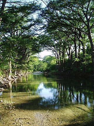
Bull Creek is a tributary of the Colorado River originating in the Texas Hill Country. The creek passes through some of the more scenic areas in the Austin region and forms a greenbelt that is the habitat for many indigenous species of flora and fauna. It runs beneath steep slopes and benches surfaced with shallow clay loams that support ashe juniper, escarpment live oak, mesquite, and grasses.

Balcones Canyonlands is a national wildlife refuge located in the Texas Hill Country to the northwest of Lago Vista, Texas. The refuge was formed in 1992 to conserve habitat for two endangered songbirds, the golden-cheeked warbler and the black-capped vireo, and to preserve Texas Hill Country habitat for numerous other wildlife species. The refuge augments a similarly named preserve in Austin called the Balcones Canyonlands Preserve.