
The Texas Hill Country is a geographic region of Central and South Texas, forming the southeast part of the Edwards Plateau. Given its location, climate, terrain, and vegetation, the Hill Country can be considered the border between the American Southeast and Southwest. The region represents the very remote rural countryside of Central Texas, but also is home to growing suburban neighborhoods and affluent retirement communities.

The Balcones Fault or Balcones Fault Zone is an area of largely normal faulting in the U.S. state of Texas that runs roughly from the southwest part of the state near Del Rio to the north-central region near Dallas along Interstate 35. The Balcones Fault zone is made up of many smaller features, including normal faults, grabens, and horsts. One of the obvious features is the Mount Bonnell Fault.

Anza-Borrego Desert State Park is a California State Park located within the Colorado Desert of southern California, United States. The park takes its name from 18th century Spanish explorer Juan Bautista de Anza and borrego, a Spanish word for sheep. With 585,930 acres (237,120 ha) that includes one-fifth of San Diego County, it is the largest state park in California.

The Santa Rosa Mountains are a short mountain range in the Peninsular Ranges system, located east of the Los Angeles Basin and northeast of the San Diego metropolitan area of southern California, in the southwestern United States.
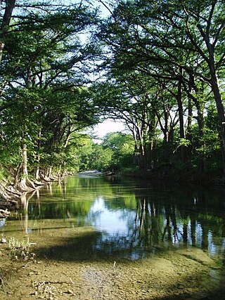
The Medina River is located in south central Texas, United States, in the Medina Valley. It was also known as the Rio Mariano, Rio San Jose, or Rio de Bagres. Its source is in springs in the Edwards Plateau in northwest Bandera County, Texas and merges with the San Antonio River in southern Bexar County, Texas, for a course of 120 miles. It contains the Medina Dam in NE Medina County, Texas which restrains Lake Medina. Much of its course is owned and operated by the Bexar-Medina-Atascosa Water District to provide irrigation services to farmers and ranchers.

Washingtonia is a genus of palms, native to the southwestern United States and northwest Mexico. Both Washingtonia species are commonly cultivated across the Southern United States, the Middle East, southern Europe, and North Africa, where they have greatly hybridized.
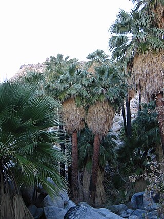
Washingtonia filifera, the desert fan palm, California fan palm, or California palm, is a flowering plant in the palm family Arecaceae, native to the far southwestern United States and Baja California, Mexico. Growing to 15–20 m (49–66 ft) tall by 3–6 m (10–20 ft) broad, it is an evergreen monocot with a tree-like growth habit. It has a sturdy, columnar trunk and waxy, fan-shaped (palmate) leaves.

Washingtonia robusta, known by common name as the Mexican fan palm, Mexican washingtonia, or skyduster is a palm tree native to the Baja California peninsula and a small part of Sonora in northwestern Mexico. Despite its limited native distribution, W. robusta one of the most widely cultivated subtropical palms in the world. It is naturalized in Florida, California, Nevada, Arizona, New Mexico, Hawaii, Texas, parts of the Canary Islands, Spain, Portugal, France, Italy, Malta, Albania, Greece, Turkey, Cyprus, Israel, Palestine, Jordan, Lebanon, Syria, Iraq, Saudi Arabia, Bahrain, Qatar, United Arab Emirates, Oman, Yemen, Iran, Afghanistan, Egypt, Libya, Tunisia, Algeria, Morocco, and Réunion,.
Indio Hills Palms Park Property and the Coachella Valley Preserve, located in the Indio Hills, contain the Thousand Palms Oasis and are a protected area in the Coachella Valley, located east of Palm Springs near Palm Desert, California. The Coachella Valley National Wildlife Refuge is contained within the Coachella Valley Preserve, and all are in the Colorado Desert section of the Sonoran Desert and adjacent to the Lower Colorado River Valley region.
The Sierra Juárez and San Pedro Mártir pine–oak forests is a Nearctic temperate coniferous forests ecoregion that covers the higher elevations of the Sierra Juárez and Sierra San Pedro Mártir ranges of the Peninsular Ranges, of the northern Baja California Peninsula of Mexico. The pine–oak forests extend throughout the central portion of the Mexican state of Baja California and terminate near the border with the U.S. state of California.

The Turtle Mountains, are located in northeastern San Bernardino County, in the southeastern part of California. The colorful Turtle Mountains vary from deep reds, browns, tans and grays, to black. The area has numerous springs and seeps. The Turtle Mountains are also a National Natural Landmark, with two mountain sections of entirely different composition.

Comal Springs are the largest concentration of naturally occurring freshwater springs in Texas. They are located in the city of New Braunfels and are the result of water percolating through the Edwards Aquifer formation.

The Texas Coastal Bend, or just the Coastal Bend, is a geographical region in the US state of Texas. The name refers to the area being a curve along the Texas Gulf Coast of the Gulf of Mexico. The largest city of the Coastal Bend is Corpus Christi. It includes the Nueces Estuary and the Mission–Aransas Estuary, as well as part of Laguna Madre. The coastline is paralleled by several of the Texas barrier islands, including North Padre Island, Mustang Island, and San José Island.
San Marcos Springs is the second largest natural cluster of springs in Texas. The springs are located in the city of San Marcos, Texas, about 30 miles (48 km) southwest of Austin and 46 miles (74 km) northeast of San Antonio.

Salado Springs is the name of five groups of springs at the town of Salado in Bell County, Texas, in the United States. The springs are located 48 miles (77 km) north of Austin or 135 miles (217 km) south of Dallas.

San Pedro Springs is the name of a cluster of springs in Bexar County, Texas, United States. These springs provide water for San Pedro Creek, which flows into the San Antonio River. The San Antonio Springs also feed into the San Antonio River.
The Sierra Pinta or Sierra Pintas are a narrow remote block faulted northwest-southeast trending mountain range, about 22 miles (35 km) long located in southwestern Arizona in the arid northwestern Sonoran Desert, just north of the Pinacate Reserve of northern Sonora, Mexico. The mountains derive their name from visitor descriptions of its multicolored hues when viewed at sunrise and sunset.
The Maria fold and thrust belt (MFTB) is a portion of the North American Cordillera orogen in which geological structures accommodate roughly north–south to northwest-southeast vergent Mesozoic age crustal shortening. This lies in contrast to the remainder of the Cordillera, in which shortening is predominantly east–west. Structures associated with the Maria Fold and Thrust Belt are exposed in a series of mountain ranges in southeastern California and western Arizona. Many of the deep structures of the MFTB have been exposed due to east–west to northeast-southwest Cenozoic age extension and unroofing.
The Mopah Range is a desert mountain range, in the Lower Colorado River Valley region, in southeastern San Bernardino County, California.
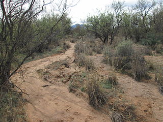
Mesquite Bosque is a vegetative association within the Southwestern United States, under the Kuchler scheme of plant association categories.
