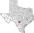
Yancey, Texas

Last updated

Yancey is a Census Designated Place in Medina County, Texas, United States. [1] It is approximately 13 miles south of Hondo on Farm to Market Road 462 and 36 miles west of San Antonio. [2] It is part of the San Antonio metropolitan area.

Contents

According to an online community profile, Yancey has a population of 649 people. It has an oil business, an RV repair business and a restaurant called "Red's Place". [3]

Demographics

Historical population
CensusPop.Note
2020 300
U.S. Decennial Census [4]
1850–1900 [5] 1910 [6]
1920 [7] 1930 [8] 1940 [9]
1950 [10] 1960 [11] 1970 [12]
1980 [13] 1990 [14] 2000 [15]
2010 [16] 2020 [17]

Yancey first appeared as a census designated place in the 2020 U.S. Census. [18] [16] [17]

2020 census

Yancey CDP, Texas – Racial and ethnic composition
Note: the US Census treats Hispanic/Latino as an ethnic category. This table excludes Latinos from the racial categories and assigns them to a separate category. Hispanics/Latinos may be of any race.
Race / Ethnicity (NH = Non-Hispanic)Pop 2020 [17] % 2020
White alone (NH)9030.00%
Black or African American alone (NH)00.00%
Native American or Alaska Native alone (NH)10.33%
Asian alone (NH)00.00%
Pacific Islander alone (NH)00.00%
Other race alone (NH)20.67%
Mixed race or Multiracial (NH)51.67%
Hispanic or Latino (any race)20267.33%
Total300100.00%

Education

It is in the Hondo Independent School District, [19] which operates Hondo High School.

Related Research Articles

<span class="mw-page-title-main">Medina County, Texas</span> County in Texas, United States

Medina County is a county located in the U.S. state of Texas. As of the 2020 census, its population was 50,748. Its county seat is Hondo. The county is named for the Medina River. The extreme northern part of the county lies within the Edwards Plateau, which elevates into the Texas Hill Country. The Medina Dam, the fourth largest in the nation when completed in 1913, is listed on the National Register of Historic Places. The irrigation project, creating Medina Lake, was built by 1500 skilled workers who worked in shifts operating 24 hours a day to complete the dam in two years. Medina County is part of the San Antonio, TX Metropolitan Statistical Area.

<span class="mw-page-title-main">Lakehills, Texas</span> CDP in Texas, United States

Lakehills is a census-designated place (CDP) in Bandera County, Texas, United States. The population was 5,295 at the 2020 census, making it the most populous place in Bandera County. It is part of the San Antonio Metropolitan Statistical Area.

Medina is a census-designated place (CDP) in Zapata County, Texas, United States. The population was 3,935 at the 2010 census.

<span class="mw-page-title-main">D'Hanis, Texas</span> Census-designated place in Texas, US

D'Hanis is a census-designated place in central Medina County, Texas, United States. It is part of the San Antonio—New Braunfels, Texas Metropolitan Statistical Area. The population was 785 at the 2020 census, up from 548 in 2000. It was primarily settled in the 1800s by German emigrants.

Lake Medina Shores is a census-designated place in Bandera and Medina counties, Texas, United States. Its population was 1,235 as of the 2010 census. This was a new CDP for the 2010 census.

Colorado Acres is a census-designated place in Webb County, Texas, United States. The population was 296 at the 2010 census. This was a new CDP, formed from parts of the Ranchitos Las Lomas CDP prior to the 2010 census.

Evergreen is a census-designated place (CDP) in Starr County, Texas, United States. It is a new CDP, formed from part of the Roma Creek CDP prior to the 2010 census, with a population of 73.

Fronton Ranchettes is a census-designated place (CDP) in Starr County, Texas, United States. It is a new CDP, formed from part of the Roma Creek CDP prior to the 2010 census, with a population of 113.

Indio is a census-designated place (CDP) in Starr County, Texas, United States. It is a new CDP, formed from part of the Falcon Heights CDP prior to the 2010 census, with a population of 50.

Sunset is a census-designated place (CDP) in Starr County, Texas, United States. It is a new CDP formed from part of the Fronton CDP prior to the 2010 census, with a population of 47.

Chapeno is a census-designated place (CDP) in Starr County, Texas, United States. This was a new CDP for the 2010 census, with a population of 47.

La Minita is a census-designated place (CDP) in Starr County, Texas, United States. This was a new CDP for the 2010 census, with a population of 171.

Hillside Acres is a census-designated place (CDP) in Webb County, Texas, United States. This was a new CDP, formed from parts of the Ranchitos Las Lomas CDP prior to the 2010 census, with a population of 30.

Las Pilas is a census-designated place (CDP) in Webb County, Texas, United States. This was a new CDP formed from parts of the Ranchitos Las Lomas CDP prior to the 2010 census, with a population of 28.

Pueblo East is an unincorporated community and census-designated place (CDP) in Webb County, Texas, United States. This was a new CDP formed from parts of the Ranchitos Las Lomas CDP prior to the 2010 census. Despite being a new CDP, the population was listed as zero in 2010.

Valle Verde is an unincorporated community and census-designated place (CDP) in Webb County, Texas, United States.

Los Arcos is a census-designated place (CDP) in Webb County, Texas, United States. This was a new CDP for the 2010 census, with a population of 127.

Los Centenarios is a census-designated place (CDP) in Webb County, Texas, United States. This was a new CDP for the 2010 census, with a population of 87.

Los Fresnos is a census-designated place (CDP) in Webb County, Texas, United States. This was a new CDP for the 2010 census, with a population of 67.

Los Nopalitos is a census-designated place (CDP) in Webb County, Texas, United States. This was a new CDP for the 2010 census, with a population of 62.

References

  1. U.S. Geological Survey Geographic Names Information System: Yancey, Texas
  2. Texas Atlas & Gazetteer, Delorme, 4th ed., 2001, p. 77 ISBN   0899333206
  3. Yancey profile on Homepages.com
  4. "Decennial Census by Decade". US Census Bureau.
  5. "1900 Census of Population - Population of Texas By Counties And Minor Civil Divisions" (PDF). United States Census Bureau .
  6. "1910 Census of Population - Supplement for Texas" (PDF). United States Census Bureau .
  7. "1920 Census of Population - Number of Inhabitants - Texas" (PDF). United States Census Bureau .
  8. "1930 Census of Population - Number of Inhabitants - Texas" (PDF). United States Census Bureau .
  9. "1940 Census of Population - Number of Inhabitants - Texas" (PDF). United States Census Bureau .
  10. "1950 Census of Population - Number of Inhabitants - Texas" (PDF). United States Census Bureau .
  11. "1960 Census of Population - Number of Inhabitants - Texas" (PDF). United States Census Bureau .
  12. "1970 Census of Population - Number of Inhabitants - Texas" (PDF). United States Census Bureau .
  13. "1980 Census of Population - Number of Inhabitants - Texas" (PDF). United States Census Bureau .
  14. "1990 Census of Population - Population and Housing Unit Counts - Texas" (PDF). United States Census Bureau .
  15. "2000 Census of Population - Population and Housing Unit Counts - Texas" (PDF). United States Census Bureau .
  16. 1 2 "2010 Census of Population - Population and Housing Unit Counts - Texas" (PDF). United States Census Bureau .
  17. 1 2 3 "P2: Hispanic or Latino, and Not Hispanic or Latino by Race – 2020: DEC Redistricting Data (PL 94-171) – Yancey CDP, Texas". United States Census Bureau.
  18. "2020 Geography Changes". United States Census Bureau.
  19. "2020 CENSUS - SCHOOL DISTRICT REFERENCE MAP: Medina County, TX" (PDF). U.S. Census Bureau. Archived (PDF) from the original on October 9, 2022. Retrieved October 29, 2024. - Text list

29°07′42″N99°07′43″W / 29.12833°N 99.12861°W / 29.12833; -99.12861