Adkins, Texas

Last updated

Adkins, Texas
USA Texas location map.svg
Red pog.svg
Adkins, Texas
Location within Texas
Usa edcp location map.svg
Red pog.svg
Adkins, Texas
Location within the United States
Coordinates: 29°23′35″N98°14′14″W / 29.39306°N 98.23722°W / 29.39306; -98.23722
CountryUnited States
State Texas
County Bexar
Elevation
[1]
558 ft (170 m)
Population
  Estimate 
(2019)
1,428
  Density597.74/sq mi (230.79/km2)
Time zone UTC−6 (Central (CST))
  Summer (DST) UTC−5 (CDT)
ZIP code
78101
Area codes 210, 726
FIPS code 48-41764
GNIS feature ID1360813 [1]

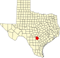
Adkins is an unincorporated community located partly in eastern Bexar County, Texas, United States. [1] It is located within the Greater San Antonio metropolitan area.

Contents

History

Adkins started as a flag station on the Galveston, Harrisburg and San Antonio Railway in the 1880s and was named for William Adkins Jones, who was given a land grant for the depot and switchyard that would develop there. A post office was established at Adkins in 1896. There were two churches and 100 people in the community in 1910, which went up to 150 in 1940 with four businesses. Its growth continued with San Antonio developing into a major city, with 241 residents and 32 businesses in 1990. [2]

Geography

Adkins is located on Farm to Market Road 1518 and Texas State Highway Loop 1604, 14 mi (23 km) east of San Antonio in eastern Bexar County. [2]

Education

Adkins had its own school in 1910. [2] Today, the community is served by the East Central Independent School District. Salem Sayers Baptist Academy also serves the community.

Adkins is home to Texas Pride Barbecue, where the season 3 finale of Diners, Drive-Ins and Dives was filmed. [3]

References

  1. 1 2 3 U.S. Geological Survey Geographic Names Information System: Adkins, Texas
  2. 1 2 3 Adkins, TX from the Handbook of Texas Online
  3. "tv.com" . Retrieved October 8, 2011.[ permanent dead link ]