Martinez, Texas

Last updated

Martinez, Texas
USA Texas location map.svg
Red pog.svg
Martinez
Usa edcp location map.svg
Red pog.svg
Martinez
Coordinates: 29°25′08″N98°20′09″W / 29.41889°N 98.33583°W / 29.41889; -98.33583
Country United States
State Texas
County Bexar
Elevation
[1]
686 ft (209 m)
Time zone UTC-6 (Central (CST))
  Summer (DST) UTC-5 (CDT)
Area code 210
GNIS feature ID1341023 [1]

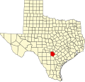
Martinez is an unincorporated community in eastern Bexar County, Texas, United States. [1] In 1990, its population was reported to be 75 residents. It is located within the Greater San Antonio metropolitan area.

Contents

History

Martinez was a station on the Galveston, Harrisburg and San Antonio Railway in 1877. Its population was 50 in 1910, with a store owned and operated by W.C. Schlather. It remained the same in 1940, with the opening of three more businesses. It continued to grow slowly, with the population reaching 75 in 1990. It was listed on county maps in 2000, but with no further population records. [2]

Geography

Martinez lies near Converse at the intersection of Farm to Market Roads 1346 and 1516, ten miles east of Downtown San Antonio. [2]

Two rivers that flow through the community are Martinez Creek and Calaveras Creek. [2]

Education

Martinez is served by the East Central Independent School District. Children in the community attend Sinclair Elementary School in San Antonio.

Related Research Articles

<span class="mw-page-title-main">San Antonio</span> City in Texas, United States

San Antonio, officially the City of San Antonio, is a city in and the county seat of Bexar County, Texas, United States. The city is the seventh-most populous in the United States, the second-largest in the Southern United States, and the second-most populous in Texas after Houston. San Antonio is the largest city of the San Antonio–New Braunfels metropolitan statistical area. Commonly called Greater San Antonio, the metropolitan area had a population of 2,601,788 based on the 2020 U.S. census estimates, making it the 24th-largest metropolitan area in the United States and third-largest in Texas.

<span class="mw-page-title-main">Bexar County, Texas</span> County in Texas, United States

Bexar County is a county in the U.S. state of Texas. It is in South Texas and its county seat is San Antonio.

<span class="mw-page-title-main">Geronimo, Texas</span> Census-designated place in Texas, United States

Geronimo is an unincorporated community and census-designated place (CDP) in Guadalupe County, Texas, United States. The population was 1,032 at the 2010 census, up from 619 at the 2000 census. It is part of the San Antonio Metropolitan Statistical Area.

<span class="mw-page-title-main">Zuehl, Texas</span> Census-designated place in Texas, United States

Zuehl is an unincorporated area and census-designated place in western Guadalupe County, Texas, United States. It is part of the San Antonio Metropolitan Statistical Area. Located on Cibolo Creek, it lies 13 miles (21 km) southwest of Seguin. The population was 362 at the 2010 census.

<span class="mw-page-title-main">Highlands, Texas</span> Census-designated place in Texas, United States

Highlands is a census-designated place (CDP) located along the Union Pacific Railroad, north of Interstate 10 and west of Farm to Market Road 2100, in an industrialized area of unincorporated Harris County, Texas, United States. The population was 8,612 at the 2020 census.

<span class="mw-page-title-main">San Marcos, Texas</span> City in Hays County, Texas, US

San Marcos is a city and the county seat of Hays County, Texas, United States. The city is a part of the Greater Austin Metropolitan Area. San Marcos's limits extend into Caldwell and Guadalupe counties, as well. San Marcos is on the Interstate 35 corridor between Austin and San Antonio. Its population was 44,894 at the 2010 census and 67,553 at the 2020 census. Founded on the banks of the San Marcos River, the area is thought to be among the oldest continuously inhabited sites in the Americas. San Marcos is home to Texas State University and the Meadows Center for Water and the Environment.

<span class="mw-page-title-main">Manchaca, Texas</span> Census-designated place in Texas, United States

Manchaca is an unincorporated community and census-designated place (CDP) in Travis County, Texas, United States. It is located 10 miles (16 km) southwest of downtown Austin. This was a new CDP for the 2020 census with a population of 2,266.

Pipe Creek is an unincorporated community in Bandera County, Texas, United States. According to the Handbook of Texas, it had a population of approximately 66 in 1990. It is part of the San Antonio Metropolitan Statistical Area.

Bandera Falls is an unincorporated community in Bandera County, Texas, United States. It is part of the San Antonio Metropolitan Statistical Area.

<span class="mw-page-title-main">Greater San Antonio</span> Metropolitan area in Texas, United States

Greater San Antonio, officially designated San Antonio–New Braunfels, is an eight-county metropolitan area in the U.S. state of Texas defined by the Office of Management and Budget (OMB). The metropolitan area straddles South Texas and Central Texas and is on the southwestern corner of the Texas Triangle. The official 2020 U.S. census showed the metropolitan area's population at 2,558,143—up from a reported 1,711,103 in 2000—making it the 24th largest metropolitan area in the United States. Austin–Round Rock lies about 80 mi (130 km) northeast of Greater San Antonio.

<span class="mw-page-title-main">Greater Austin</span> Metropolitan area in Texas, United States

The Austin–Round Rock–San Marcos metropolitan statistical area, or Greater Austin, is a five-county metropolitan area in the U.S. state of Texas, as defined by the Office of Management and Budget. The metropolitan area is situated in Central Texas on the western edge of the American South and on the eastern edge of the American Southwest, and borders Greater San Antonio to the south.

Campbellton is an unincorporated community in Atascosa County, Texas, United States. According to the Handbook of Texas, the community had an estimated population of 350 in 2000. Campbellton is part of the San Antonio Metropolitan Statistical Area.

Harwood is a ghost town in Gonzales County, Texas. According to the Handbook of Texas, the community had an estimated population of 112 in 2000.

Austonio is an unincorporated community in Houston County, Texas, United States. According to the Handbook of Texas, the community had a population of 37 in 2000.

Losoya is an unincorporated community in Bexar County, Texas, United States. According to the Handbook of Texas, the community had a population of 322 in 2000. It is a part of the San Antonio–New Braunfels metropolitan area.

McMahan is an unincorporated community in Caldwell County, in the U.S. state of Texas. According to the Handbook of Texas, the community had a population of 125 in 2000. It is located within the Greater Austin metropolitan area.

<span class="mw-page-title-main">History of African Americans in San Antonio</span> Aspect of history

The African American population in San Antonio, Texas has been a significant part of the city's community since its founding. African Americans have been a part of the Greater San Antonio's history since the late 1800s. San Antonio ranks as the top Texas destination city for Black professionals.

Olmos is an unincorporated community in Bee County, in the U.S. state of Texas. According to the Handbook of Texas, the community had no population estimates in 2000. It is located within the Beeville micropolitan area.

Bexar is an unincorporated community in Bexar County, in the U.S. state of Texas. It is located within the Greater San Antonio metropolitan area.

Southon is an unincorporated community in Bexar County, in the U.S. state of Texas. According to the Handbook of Texas, the community had a population of 113 in 2000. It is located within the Greater San Antonio metropolitan area.

References