Thelma, Texas

Last updated

Thelma, Texas
USA Texas location map.svg
Red pog.svg
Thelma
Usa edcp location map.svg
Red pog.svg
Thelma
Coordinates: 29°12′51″N98°30′6″W / 29.21417°N 98.50167°W / 29.21417; -98.50167
Country United States
State Texas
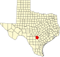
County Bexar
Elevation
[1]
574 ft (175 m)
Time zone UTC-6 (Central (CST))
  Summer (DST) UTC-5 (CDT)
Area code(s) 210, 726
GNIS feature ID1380654 [1]

Thelma is an unincorporated community in Bexar County, in the U.S. state of Texas. [1] According to the Handbook of Texas, the community had a population of 45 in 2000. It is located within the Greater San Antonio metropolitan area.

Contents

History

Established around the turn of the twentieth century, and with a post-office built in 1906, Thelma became a station on the an Antonio, Uvalde and Gulf Railroad in 1912. In the 1940s, the community had four dairies. After World War II, the town's population declined. [2]

Historical population of Thelma, Texas
(Source: [2] )
Year191419402000
Population3002545

Geography

Thelma is located at the intersection of Texas State Highway Loop 1604 and the Southern Pacific Railroad, 15 mi (24 km) south of Downtown San Antonio in southern Bexar County. [2]

Education

Thelma is served by the Southside Independent School District.

References

  1. 1 2 3 U.S. Geological Survey Geographic Names Information System: Thelma, Texas
  2. 1 2 3 Long, Christopher. "Thelma, TX (Bexar County)". tshaonline.org. Retrieved August 13, 2022.