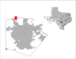
Fair Oaks Ranch, Texas | |
---|---|
Motto: "Where Community Spirit Overflows!" | |
Coordinates: 29°45′14″N98°38′03″W / 29.75389°N 98.63417°W | |
Country | United States |
State | Texas |
Counties | Bexar, Kendall, Comal |
Area | |
• Total | 12.29 sq mi (31.82 km2) |
• Land | 12.26 sq mi (31.76 km2) |
• Water | 0.03 sq mi (0.06 km2) |
Elevation | 1,263 ft (385 m) |
Population (2020) | |
• Total | 9,833 |
• Density | 800/sq mi (310/km2) |
Time zone | UTC-6 (Central (CST)) |
• Summer (DST) | UTC-5 (CDT) |
ZIP code | 78015 |
Area code | 830 |
FIPS code | 48-25168 [3] |
GNIS feature ID | 2410473 [2] |
Website | fairoaksranchtx |
Fair Oaks Ranch is a city in Bexar, Comal, and Kendall counties in the U.S. state of Texas. The population was 9,833 at the 2020 census, [4] and an estimated 10,505 in 2021. [5] It is part of the San Antonio-New Braunfels Metropolitan Statistical Area. The city was named after Ralph Fair Sr, an oilman who had a large cattle ranch on the now residential town. The Fair family decided to sell a portion of the ranch to build what is now Fair Oaks Ranch in 1975. [6]
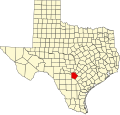
The land on which Fair Oaks Ranch rests was acquired in the 1930s by Ralph Fair Sr., who worked in the oil industry and owned cattle and racehorses. A residential community was established by Fair's family in the 1970s and the community was incorporated in 1988. [7]
Fair Oaks Ranch is located on both sides of Cibolo Creek, 27 miles (43 km) northwest of downtown San Antonio and 8 miles (13 km) southeast of Boerne. The city limits extend southwest to touch Interstate 10 at Exit 546.
According to the United States Census Bureau, the city has a total area of 8.5 square miles (22.1 km2), of which 0.023 square miles (0.06 km2), or 0.26%, is water. [8]
Census | Pop. | Note | %± |
---|---|---|---|
1990 | 1,860 | — | |
2000 | 4,695 | 152.4% | |
2010 | 5,986 | 27.5% | |
2020 | 9,833 | 64.3% | |
2021 (est.) | 10,505 | [5] | 6.8% |
U.S. Decennial Census [9] |
Race | Number | Percentage |
---|---|---|
White (NH) | 7,368 | 74.93% |
Black or African American (NH) | 162 | 1.65% |
Native American or Alaska Native (NH) | 14 | 0.14% |
Asian (NH) | 152 | 1.55% |
Pacific Islander (NH) | 5 | 0.05% |
Some Other Race (NH) | 51 | 0.52% |
Mixed/Multi-Racial (NH) | 376 | 3.82% |
Hispanic or Latino | 1,705 | 17.34% |
Total | 9,833 |
As of the 2020 United States census, there were 9,833 people, 3,771 households, and 2,969 families residing in the city.
As of the census [3] of 2000, there were 4,695 people, 1,683 households, and 1,531 families residing in the city. The population density was 656.4 inhabitants per square mile (253.4/km2). There were 1,731 housing units at an average density of 242.0 units per square mile (93.4 units/km2). The racial makeup of the city was 96.38% White, 0.38% African American, 0.43% Native American, 0.62% Asian, 0.06% Pacific Islander, 1.04% from other races, and 1.09% from two or more races. Hispanic or Latino of any race were 7.90% of the population.
There were 1,683 households, out of which 34.8% had children under the age of 18 living with them, 86.4% were married couples living together, 3.7% had a female householder with no husband present, and 9.0% were non-families. 7.4% of all households were made up of individuals, and 3.5% had someone living alone who was 65 years of age or older. The average household size was 2.79 and the average family size was 2.93.
In the city, the population was spread out, with 25.1% under the age of 18, 3.8% from 18 to 24, 19.3% from 25 to 44, 38.0% from 45 to 64, and 13.7% who were 65 years of age or older. The median age was 46 years. For every 100 females, there were 101.2 males. For every 100 females age 18 and over, there were 96.9 males.
The median income for a household in the city was $99,685, and the median income for a family was $101,751. Males had a median income of $72,031 versus $43,750 for females. The per capita income for the city was $45,293. About 1.5% of families and 1.7% of the population were below the poverty line, including 1.3% of those under age 18 and 4.4% of those age 65 or over.
Most of the city of Fair Oaks Ranch is served by the Boerne Independent School District. [13] [14] [15] The public schools that serve the BISD parts of Fair Oaks Ranch are Fair Oaks Ranch ES (K–5), Van Raub ES (K–5), Boerne Middle School South (6–8), Captain Mark Tyler Voss Middle School (6–8), and Boerne Champion High School (9–12). [16]
A portion of Fair Oaks Ranch in Comal County is in the Comal Independent School District. [14] The Comal County portion is zoned to Rahe Bulverde Elementary School, [17] Spring Branch Middle School, [18] and Smithson Valley High School. [19]
Webb County is a county located in the U.S. state of Texas. As of the 2020 census, its population was 267,114. Its county seat is Laredo. The county was named after James Webb (1792–1856), who served as secretary of the treasury, secretary of state, and attorney general of the Republic of Texas, and later judge of the United States District Court following the admission of Texas to statehood. By area, Webb County is the largest county in South Texas and the sixth-largest in the state. Webb County comprises the Laredo metropolitan area. Webb County is the only county in the United States to border three foreign states or provinces, sharing borders with Coahuila, Nuevo Leon, and Tamaulipas.
Live Oak County is a county in the U.S. state of Texas. It was named for its native groves of live oak. George West is its county seat. Its population was 11,335 in the 2020 census.
Kendall County is a county located on the Edwards Plateau in the U.S. state of Texas. In 2020 census, its population was 44,279. Its county seat is Boerne. The county is named for George Wilkins Kendall, a journalist and Mexican–American War correspondent.
Hutchinson County is a county in the U.S. state of Texas. As of the 2020 census, its population was 20,617. Its county seat is Stinnett. The county was created in 1876, but not organized until 1901. It is named for Andrew Hutchinson, an early Texas attorney.
Scenic Oaks is a census-designated place (CDP) in Bexar County, Texas, United States. It is part of the San Antonio Metropolitan Statistical Area. The population was 10,458 at the 2020 census, up from 4,957 at the 2010 census.
Timberwood Park is a census-designated place (CDP) in far northern unincorporated Bexar County, Texas, United States and located within the southern edge of the Texas Hill Country. The district has roughly 42 miles of roads and encompasses over 2,000 acres. The overall plan shows 3,263 platted lots. The population was 35,217 at the 2020 census, up from 13,447 at the 2010 census. It is part of the San Antonio Metropolitan Statistical Area.
Bulverde is a city in Comal County, Texas, United States. Bulverde is known for its small-town, slow pace of life, coupled with the German emigrant history of the town's founders. Bulverde was originally named Piepers Settlement after a prominent German pioneer. Its population was 5,692 at the 2020 census, up from 4,630 at the 2010 census. It is part of the San Antonio metropolitan statistical area.
Bayou Vista is a city in Galveston County, Texas, United States. The population was 1,763 at the 2020 census. It received severe damage from Hurricane Ike on September 13, 2008.
Boerne is a city in and the county seat of Kendall County, Texas, United States, in the Texas Hill Country. Boerne is known for its German-Texan history, named in honor of German author and satirist Ludwig Börne by the German Founders of the town. The population of Boerne was 10,471 at the 2010 census, and in 2020 the population was 17,850. The city is noted for the landmark U.S. Supreme Court case City of Boerne v. Flores. Founded in 1849 as "Tusculum", the name was changed to "Boerne" when the town was platted in 1852.
North Cleveland is a city within the Houston–The Woodlands–Sugar Land metropolitan area and Liberty County, Texas, United States. The population was 225 at the 2020 census.
Wolfforth is a town located in Lubbock County, Texas, United States. It is a southwestern suburb of Lubbock. The population was 5,521 at the 2020 census.
Stanton is a city in and the county seat of Martin County, Texas, United States. Stanton was founded as Marienfeld by German immigrants that were some of the first settlers in this region of Texas. The population was 2,657 at the 2020 census.
Goldthwaite is a town and the county seat of Mills County, Texas, United States. The population was 1,738 at the 2020 census, down from 1,878 at the 2010 census.
New London is a city in Rusk County, Texas, United States. The population was 958 at the 2020 census.
Falcon Heights is a census-designated place (CDP) in Starr County, Texas, United States. The population was 18 at the 2020 census, down from 53 at the 2010 census.
La Rosita is a census-designated place (CDP) in Starr County, Texas, United States. The population was 85 at the 2010 census, a decline from the figure of 1,729 tabulated in 2000 due to the Census Bureau redefining the CDP. By the 2020 census, the population further decreased to 82.
Roma Creek is a former census-designated place (CDP) in Starr County, Texas, United States. The population was 350 at the 2010 census down from 610 at the 2000 census.
Brushy Creek is a census-designated place (CDP) in Williamson County, Texas, United States. The population was 22,519 at the 2020 census.
Selma is a city in Bexar, Comal, and Guadalupe counties in Texas, United States. It is part of the San Antonio metropolitan statistical area. Its population was 10,952 at the 2020 census, up from 5,540 at the 2010 census. Selma was settled by German and Polish immigrants in the mid-1800s.
Sachse is a city in Collin and Dallas counties in the U.S. state of Texas and is part of the DFW metroplex. A northeastern suburb of Dallas, the city population was 27,103, as of the 2020 census with an estimated population of 33,768 people today. Sachse is located off Texas State Highway 78 and President George Bush Turnpike and is approximately 1 mile (1.6 km) north of the Firewheel Town Center.