Related Research Articles

Young County is a county located in the U.S. state of Texas. As of the 2020 census, its population was 17,867. Its county seat is Graham. The county was created in 1856 and organized in 1874. It is named for William Cocke Young, an early Texas settler and soldier.
Washington County is a county in Texas. As of the 2020 census, the population was 35,805. Its county seat is Brenham, which is located along U.S. Highway 290, 72 miles northwest of Houston. The county was created in 1835 as a municipality of Mexico and organized as a county in 1837. It is named for George Washington, the first president of the United States.

Val Verde County is a county located on the southern Edwards Plateau in the U.S. state of Texas. The 2020 population is 47,586. Its county seat is Del Rio. The Del Rio micropolitan statistical area includes all of Val Verde County.

Llano County is a county located on the Edwards Plateau in the U.S. state of Texas. As of the 2020 census, its population was 21,243. Its county seat is Llano, and the county is named for the Llano River.

Lampasas County is a county located on the Edwards Plateau in the U.S. state of Texas. As of the 2020 census, its population was 21,627. Its county seat is Lampasas. The county is named for the Lampasas River.

Kendall County is a county located on the Edwards Plateau in the U.S. state of Texas. In 2020 census, its population was 44,279. Its county seat is Boerne. The county is named for George Wilkins Kendall, a journalist and Mexican–American War correspondent.
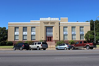
Gillespie County is a county located on the Edwards Plateau in the U.S. state of Texas. As of the 2020 census, its population was 26,725. The county seat is Fredericksburg. It is located in the heart of the rural Texas Hill Country in Central Texas. Gillespie is named for Robert Addison Gillespie, a soldier in the Mexican–American War.

Garza County is a county located in the U.S. state of Texas. As of the 2020 census, its population was 5,816, of which most of the population were residing in its county seat, and only incorporated municipality, Post. The county was created in 1876 and later organized in 1907. Garza is named for a pioneer Bexar County family, as it was once a part of that county.

Edwards County is a county located on the Edwards Plateau in the U.S. state of Texas. As of the 2020 census its population was 1,422. The county seat is Rocksprings. The county was created in 1858 and organized in 1883. It is named for Haden Edwards, an early settler of Nacogdoches, Texas. The Edwards Aquifer and Edwards Plateau are named after the county by reason of their locations.

Comal County is a county located on the Edwards Plateau in the U.S. state of Texas. As of the 2020 census, its population was 161,501. Comal County is known for its rich German-Texan and European history. Its county seat is New Braunfels.
Mico is an unincorporated community in northeastern Medina County, Texas, United States. It is approximately 40 miles (64 km) west of Downtown San Antonio off Farm to Market Road 1283. The community is part of the San Antonio Metropolitan Statistical Area (MSA). Its zip code is 78056.
Independence is an unincorporated community in Washington County, Texas, United States. According to the Handbook of Texas, the community had a population of 140 in 2000. It is located within the Greater Houston metropolitan area.
Baby Head Cemetery is a cemetery located on Highway 16, approximately 9 miles north of the city of Llano, Texas. Designated a Recorded Texas Historic Landmark in 1991, Marker 9432. The sign reads as follows:
According to local oral tradition, the name Babyhead was given to the mountain in this area in the 1850s when a small child was killed by Native Americans in the United States, and its remains left on the mountain. A local creek also carried the name, and a pioneer community founded in the 1870s became known as Baby Head. The oldest documented grave here is that of another child, Jodie May McKneely, who died on New Year's Day 1884. The cemetery is the last physical reminder of the Baby Head community, which once had numerous farms, homes and businesses.
Delmita is a census-designated place in Starr County, Texas, United States. Its elevation is 272 feet (83 m). Although Delmita is unincorporated, it has a post office, with the ZIP code of 78536. This CDP was new for the 2010 census with a population of 216.

Tres Palacios Bay is a northeastern extension of Matagorda Bay on the Texas coast in Matagorda County. It is fed by the Tres Palacios River. The city of Palacios is located on its shores. A channel that connects Palacios to the Intracoastal Waterway has been dredged through the bay.
Cundiff is an unincorporated hamlet in northeastern Jack County, Texas, United States. The community is approximately 12 miles (19 km) northeast of Jacksboro. It was named for Harrell Cundiff, one of the first settlers of Jack County. There is a church there, and an outfitter, but no other businesses or services.
Bettina is a vanished community founded in 1847 by German immigrants as part of the Adelsverein colonization of the Fisher–Miller Land Grant in the U.S. state of Texas. It was located on the banks of the Llano River in Llano County, and no trace of the settlement remains today. The community was named after German artist and social activist Bettina von Arnim and was one of five attempted by the Darmstadt Forty. It was also known as the Darmstaedter Kolonie. The community was sponsored by the Adelsverein, and founded on idealistic philosophies of European freethinkers of the day. It is notable for the community's camaraderie and mutually respectful relations with local indigenous tribes. Lack of a formal community framework caused Bettina to fail within a year of its founding.
Clear Springs is a historic settlement in Guadalupe County, Texas, United States. It is part of the San Antonio Metropolitan Statistical Area. It shares its name with the nearby Clear Springs Air Force Base.
Schumansville is a historic German settlement in Guadalupe County, Texas, United States. It is an unincorporated community.
References
- ↑ Cameron, Minnie B. (1952). The Handbook of Texas. Vol. 1. Austin, TX: Texas State Historical Association. p. 642. OCLC 3095662.
- ↑ Long, Christopher (1952). "Fratt, TX". Handbook of Texas Online. Texas State Historical Association. Archived from the original on 2021-11-12. Retrieved 2021-11-12.
Municipalities and communities of Bexar County, Texas, United States | ||
|---|---|---|
| Cities |  | |
| Towns | ||
| CDPs | ||
| Other communities | ||
| Ghost towns | ||
| Footnotes | ‡This populated place also has portions in an adjacent county or counties | |
29°31′03″N98°23′49″W / 29.51750°N 98.39694°W
 | This article about a location in Bexar County, Texas is a stub. You can help Wikipedia by expanding it. |