Cottage Hill, Texas

Last updated

Cottage Hill was a settlement that once existed in eastern Bexar County, Texas, United States. [1] [2]

Contents

History

The beginning

In the 1840s the Irvin family settled at the 18 mile marker on the San Antonio to Gonzales road. Soon after, D. A. Saltmarsh established there a stagecoach stop. In 1855, two wealthy speculators, Gideon Lee and Joseph Beck, purchased land and laid out a town called Cottage Hill. Henry Bowers opened the 20 mile house just east of town, soon William A. Jackson opened a general store and was the first postmaster. [3]

Post Civil War - incidents of violence

After the end of the Civil War Cottage Hill became known for lawlessness and violence. In 1876 a well known gunfight happened in Cottage Hill, in which Tom Secrest and William Irvin were killed, James Applewhite of La Vernia was brought before a grand jury but was released. A gang of 12 young men who robbed and terrorized the area called themselves the Cottage Hill gang. In 1877 John Humphrey was ambushed bringing mail from San Antonio and died a day later. This incident caused the post office to be transferred to nearby Saint Hedwig. The result was a steady decline of Cottage Hill as businesses moved to Saint Hedwig. [3] [4]

Present Day

As of 2021, only forgotten ruins and gravestones remain where the town of Cottage Hill once stood. [3]

Related Research Articles

<span class="mw-page-title-main">San Antonio</span> City in Texas, United States

San Antonio, officially the City of San Antonio, is a city in the U.S. state of Texas and the most populous city in Greater San Antonio, the third-largest metropolitan area in Texas and the 24th-largest metropolitan area in the United States at 2.6 million people in the 2020 US census. It is the most populous city in and the county seat of Bexar County. The city is the seventh-most populous in the United States, the second-largest in the Southern United States, and the second-most populous in Texas after Houston.

<span class="mw-page-title-main">Gonzales County, Texas</span> County in Texas, United States

Gonzales County is a county in the U.S. state of Texas, adjacent to Greater Austin-San Antonio. As of the 2020 census, its population was 19,653. The county is named for its county seat, the city of Gonzales. The county was created in 1836 and organized the following year. As of August 2020, under strict budgetary limitations, the County of Gonzales government-body is unique in that it claims to have no commercial paper, regarding it as "the absence of any county debt."

<span class="mw-page-title-main">Bexar County, Texas</span> County in Texas, United States

Bexar County is a county in the U.S. state of Texas. It is in South Texas and its county seat is San Antonio.

<span class="mw-page-title-main">St. Hedwig, Texas</span> Town in Texas, United States

St. Hedwig is a rural town in Bexar County, Texas, United States founded by German and Polish emigrants in 1852. The population was 2,227 at the 2020 census. It is part of the San Antonio Metropolitan Statistical Area. It was founded by German and Polish emigrants and named after Saint Hedwig, a prominent Germanic saint in the Catholic Church.

<span class="mw-page-title-main">Gonzales, Texas</span> City in Austin Chalk, Eagle Ford Shale

Gonzales is a city in the U.S. state of Texas, with a population of 7,165 at the 2020 census. It is the county seat of Gonzales County. The "Come and Take It" incident, the ride of the Immortal 32 into the Alamo, and the Runaway Scrape after the fall of the Alamo, all integral events in the War for Texas Independence from Mexico, originated in Gonzales.

<span class="mw-page-title-main">Seguin, Texas</span> City in Texas, United States

Seguin is a city in and the county seat of Guadalupe County, Texas, United States. The population was 29,433 at the 2020 census, and according to 2023 census estimates, the city is estimated to have a population of 36,013. Its economy is primarily supported by a regional hospital, as well as the Schertz-Seguin Local Government Corporation water-utility, that supplies the surrounding Greater San Antonio areas from nearby aquifers as far as Gonzales County. Several dams in the surrounding area are governed by the main offices of the Guadalupe-Blanco River Authority, headquartered in downtown Seguin.

<span class="mw-page-title-main">Zuehl, Texas</span> Census-designated place in Texas, United States

Zuehl is an unincorporated area and census-designated place in western Guadalupe County, Texas, United States. It is part of the San Antonio Metropolitan Statistical Area. Located on Cibolo Creek, it lies 13 miles (21 km) southwest of Seguin. The population was 399 at the 2020 census.

<span class="mw-page-title-main">Castroville, Texas</span> City in Texas, United States

Castroville is a city in Medina County, Texas, United States. Its population was 2,954 at the 2020 census. Prior to 1893, Castroville was the first county seat of Medina County. Castroville was founded by Alsatian-Texans, who came to Texas during the German emigration period of the mid-1800s. Most Alsatians who came to Castroville spoke Alsatian. The Alsatian culture and language are still kept alive by the residents of Castroville.

<span class="mw-page-title-main">Battle of Gonzales</span> First military engagement of the Texas Revolution

The Battle of Gonzales was the first military engagement of the Texas Revolution. It was fought near Gonzales, Texas, on October 2, 1835, between rebellious Texian settlers and a detachment of Mexican army soldiers.

<span class="mw-page-title-main">Missouri–Kansas–Texas Railroad</span> Former American Class I railroad

The Missouri–Kansas–Texas Railroad was a Class I railroad company in the United States, with its last headquarters in Dallas, Texas. Established in 1865 under the name Union Pacific Railroad (UP), Southern Branch, it came to serve an extensive rail network in Texas, Oklahoma, Kansas, and Missouri. In 1988, it merged with the Missouri Pacific Railroad; today, it is part of UP.

<span class="mw-page-title-main">Area codes 210 and 726</span> North American telephone area codes near San Antonio, Texas

Area codes 210 and 726 are telephone area codes in the North American Numbering Plan (NANP) for the San Antonio area in the U.S. state of Texas. Area code 210 was created in an area code split from number plan area 512 in 1992. After only a few years, the threat of number exhaustion forced a reduction of the size of the numbering plan area to the center of the San Antonio metropolitan area in 1997. Area code 726 was assigned to the same numbering plan area in an overlay complex activated in 2017 to alleviate the threat of exhaustion of central office codes that was expected by 2018. Area codes 210 and 726 are enclave codes for an area completely surrounded by numbering plan area 830.

Kicaster Creek is a short stream in Wilson County, Texas. The creek begins in the recharge zone for the Carrizo-Wilcox Aquifer, near Kicaster, six miles southwest of the town of La Vernia. It flows through the Sand Hills Region of Wilson County for eleven miles southeastward to its mouth three miles northwest of the town of Floresville on the San Antonio River.

<span class="mw-page-title-main">Ciudad Mier</span> Place

Mier, also known as El Paso del Cántaro, is a city in Mier Municipality in Tamaulipas, located in northern Mexico near the Rio Grande, just south of Falcon Dam. It is 90 miles (140 km) northeast of Monterrey on Mexican Federal Highway 2.

Carpenter is a small unincorporated community in western Wilson County, Texas, United States. It lies between the towns of La Vernia and St. Hedwig on Farm to Market Road 1346. The community is part of the San Antonio Metropolitan Statistical Area.

<span class="mw-page-title-main">Greater San Antonio</span> Metropolitan Statistical Area in Texas, United States

Greater San Antonio, officially designated San Antonio–New Braunfels, is an eight-county metropolitan area in the U.S. state of Texas defined by the Office of Management and Budget (OMB). The metropolitan area straddles South Texas and Central Texas and is on the southwestern corner of the Texas Triangle. The official 2020 U.S. census showed the metropolitan area's population at 2,558,143—up from a reported 1,711,103 in 2000—making it the 24th largest metropolitan area in the United States. Downtown Austin and Downtown San Antonio are approximately 80 miles (129 km) apart, and both fall along the Interstate 35 corridor. This combined metropolitan region of San Antonio–Austin has approximately 5 million people.

<span class="mw-page-title-main">Leesville, Texas</span> Unincorporated City

Leesville is an unincorporated city in the Gonzales—Guadalupe County area in Texas, United States with a population of 384 residents as of 2018.

<span class="mw-page-title-main">Mathew Caldwell</span> Texas settler

Matthew Caldwell,, also spelled Mathew Caldwell was a 19th-century Texas settler, military figure, Captain of the Gonzales – Seguin Rangers and a signer of the Texas Declaration of Independence. Because of his recruitment ride ahead of the Battle of Gonzales, some call him the Paul Revere of Texas.

Bankersmith is a ghost town in Kendall County, Texas, United States. The town was founded in 1913. It lies approximately halfway between Fredericksburg and Comfort, near the border of Gillespie County.

<span class="mw-page-title-main">Farm to Market Road 466</span> Road in Texas, USA

Farm to Market Road 466 is a farm to market road, a state maintained road which serves to connect the agricultural area Leesville-Belmont to market towns, in the U.S. state of Texas. It is located in Guadalupe and Gonzales counties. The road is 34.4 miles (55.4 km) long. Locally it has been known as Capote Road for more than 100 years.

Petersburg, Texas was the seat of Lavaca County when it was organized in August 1846 but is now a ghost town. It was located six miles southeast of Hallettsville on Farm to Market Road 2616 on the east bank of the Lavaca River.

References

  1. Allen & Regina Kosub (November 18, 2014). "The Old Gonzales Road". Lost Texas Roads. Retrieved April 28, 2021.
  2. "Cottage Hill | Texas Almanac". texasalmanac.com. November 22, 2010. Retrieved April 28, 2021.
  3. 1 2 3 "TSHA | Cottage Hill, TX". Handbook of Texas online. Texas State Historical Association. Retrieved April 5, 2021.
  4. The Monitor Guide to Post Offices and Railroad Stations in the United States and Canada: With Shipping Directions by Express and Freight Lines. Bullinger's Guides, Incorporated. 1876.
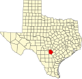

29°22′22″N98°12′00″W / 29.3727°N 98.1999°W / 29.3727; -98.1999