Marion, Texas

Last updated

Marion, Texas
Marion-public-schools2015-2.jpg
Marion public library
TXMap-doton-Marion.PNG
Location of Marion, Texas
Guadalupe County Marion.svg
Coordinates: 29°34′21″N98°08′35″W / 29.57250°N 98.14306°W / 29.57250; -98.14306
Country United States
State Texas
County Guadalupe
Area
[1]
  Total0.78 sq mi (2.02 km2)
  Land0.78 sq mi (2.02 km2)
  Water0.00 sq mi (0.00 km2)
Elevation
[2]
650 ft (200 m)
Population
 (2020)
  Total1,034
  Density1,588.99/sq mi (613.50/km2)
Time zone UTC-6 (Central (CST))
  Summer (DST) UTC-5 (CDT)
ZIP code
78124
Area code 830
FIPS code 48-46692 [3]
GNIS feature ID2411036 [2]
Website cityofmariontx.org

Marion is a city in Guadalupe County, Texas, United States. The town was incorporated by 1941. The population was 1,034 at the 2020 census. [4] It is part of the San Antonio Metropolitan Statistical Area.

Contents

History

The town is named after Marion Dove, whose grandfather, Joshua W. Young, owned a plantation that the Galveston, Harrisburg and San Antonio Railway passed through in 1877. [5]

Geography

Farm to Market Road 78 passes through the center of town, leading west 26 miles (42 km) to San Antonio and east 12 miles (19 km) to Seguin, the Guadalupe County seat.

According to the United States Census Bureau, Marion has a total area of 0.77 square miles (2.0 km2), all land. [4]

Marion is a small town that has a 3A school (mascot is the Marion Bulldogs) and a few businesses, including a hardware store, meat market, gas stations and several restaurants.

Demographics

Historical population
CensusPop.Note
1880 90
1940 373
1950 43917.7%
1960 55726.9%
1970 65517.6%
1980 6742.9%
1990 98446.0%
2000 1,09911.7%
2010 1,066−3.0%
2020 1,034−3.0%
U.S. Decennial Census [6]
Marion racial composition as of 2020 [7]
(NH = Non-Hispanic) [lower-alpha 1]
RaceNumberPercentage
White (NH)47445.84%
Black or African American (NH)535.13%
Asian (NH)40.39%
Pacific Islander (NH)10.1%
Mixed/Multi-Racial (NH)212.03%
Hispanic or Latino 48146.52%
Total1,034

As of the 2020 United States census, there were 1,034 people, 386 households, and 255 families residing in the city.

As of the census [3] of 2000, there were 1,099 people in the city. The population density was 1,544.0 inhabitants per square mile (596.1/km2). There were 393 housing units at an average density of 561.4 per square mile (216.8/km2). The racial makeup of the city was 74.25% White, 6.01% African American, 1.09% Native American, 1.09% Asian, 16.01% from other races, and 1.55% from two or more races. Hispanic or Latino of any race were 37.22% of the population.

There were 393 households, out of which 43.7% had children under the age of 18 living with them, 59.6% were married couples living together, 18.1% had a female householder with no husband present, and 19.4% were non-families. 17.5% of all households were made up of individuals, and 6.7% had someone living alone who was 65 years of age or older. The average household size was 2.95 and the average family size was 3.32 which can be directly compared to the US's average household size of 2.59 and average family size of 3.14.

In the city, the population was spread out, with 30.9% under the age of 18, 7.8% from 18 to 24, 29.8% from 25 to 44, 20.4% from 45 to 64, and 11.1% who were 65 years of age or older. The median age was 34 years. For every 100 females, there were 96.3 males. For every 100 females age 18 and over, there were 84.7 males.

The median income for a household in the city was $36,635, and the median income for a family was $40,625. Males had a median income of $27,125 versus $21,771 for females. The per capita income for the city was $13,302. About 7.0% of families and 8.4% of the population were below the poverty line, including 9.7% of those under age 18 and 13.8% of those age 65 or over.

Education

The city is served by the Marion Independent School District. A small portion is served by the Schertz-Cibolo-Universal City Independent School District.

Related Research Articles

<span class="mw-page-title-main">Sunset, Arkansas</span> Town in Arkansas, United States

Sunset is a town in Crittenden County, Arkansas, United States. The population was 198 at the 2010 census.

<span class="mw-page-title-main">Thomasboro, Illinois</span> Village in Illinois, United States

Thomasboro is a village in Champaign County, Illinois, United States. The population was 1,034 at the 2020 census.

<span class="mw-page-title-main">Robins, Iowa</span> City in Iowa, United States

Robins is a city in Linn County, Iowa, United States. The population was 3,353 at the time of the 2020 census. It is a suburb of Cedar Rapids and part of the Cedar Rapids Metropolitan Statistical Area.

<span class="mw-page-title-main">Ellinwood, Kansas</span> City in Barton County, Kansas

Ellinwood is a city in the southeast corner of Barton County, Kansas, United States. As of the 2020 census, the population of the city was 2,011.

<span class="mw-page-title-main">Chase, Kansas</span> City in Rice County, Kansas

Chase is a city in Rice County, Kansas, United States. As of the 2020 census, the population of the city was 396.

<span class="mw-page-title-main">Woodmere, Ohio</span> Village in Ohio, United States

Woodmere is a village in Cuyahoga County, Ohio, United States. As of the 2020 census, Woodmere had a population of 641 residents. An eastern suburb of Cleveland, it is part of the Cleveland metropolitan area.

<span class="mw-page-title-main">East Hanover Township, Lebanon County, Pennsylvania</span> Township in Pennsylvania, United States

East Hanover Township is a township in Lebanon County, Pennsylvania, United States. The population was 2,801 at the 2010 census. It is part of the Lebanon, PA Metropolitan Statistical Area.

<span class="mw-page-title-main">Charlotte, Texas</span> City in Atascosa County, Texas, United States

Charlotte is a city in Atascosa County, Texas, United States. The population was 1,524 at the 2020 census. It is part of the San Antonio Metropolitan Statistical Area. The town is named for Charlotte Simmons, the daughter of Dr. Charles Simmons, who aided in the development of Atascosa County.

<span class="mw-page-title-main">Poteet, Texas</span> City in Texas, United States

Poteet is a city in Atascosa County, Texas, United States. The population was 2,795 as of the 2020 census. It is part of the San Antonio Metropolitan Statistical Area. It was named for its first postmaster, Francis Marion Poteet. It is best known as the birthplace of country music legend George Strait.

<span class="mw-page-title-main">Tornillo, Texas</span> Place in Texas, United States

Tornillo is a border town in El Paso County, Texas, United States. The population was 1,568 at the 2010 census. For statistical purposes, the United States Census Bureau has defined this unincorporated community as a census-designated place (CDP). It is part of the El Paso Metropolitan Statistical Area. The Tornillo and Guadalupe, Chihuahua, area is connected by the Tornillo–Guadalupe International Bridge.

<span class="mw-page-title-main">New Berlin, Texas</span> City in Texas, United States

New Berlin is a city in Guadalupe County, Texas, United States. The population was 511 at the 2010 census. New Berlin is a German-Texan town settled by German emigrants in the 1800s as a farming community. New Berlin is named after Berlin, Germany and boasts many residents being descendants of the original German founders.

<span class="mw-page-title-main">Redwood, Texas</span> Unincorporated community in Texas, United States

Redwood is an unincorporated community and census-designated place (CDP) in Guadalupe County, Texas, United States. The population was 4,003 at the 2020 census, a decline from the figure of 4,338 tabulated in 2010. It is part of the San Antonio Metropolitan Statistical Area.

<span class="mw-page-title-main">Santa Clara, Texas</span> City in Texas, United States

Santa Clara is a city in Guadalupe County, Texas, United States. The population was 778 at the 2020 census, up from 725 at the 2010 census. It is part of the San Antonio Metropolitan Statistical Area.

<span class="mw-page-title-main">Zuehl, Texas</span> Census-designated place in Texas, United States

Zuehl is an unincorporated area and census-designated place in western Guadalupe County, Texas, United States. It is part of the San Antonio Metropolitan Statistical Area. Located on Cibolo Creek, it lies 13 miles (21 km) southwest of Seguin. The population was 399 at the 2020 census.

<span class="mw-page-title-main">Ingram, Texas</span> City in Texas, United States

Ingram is a city in Kerr County, Texas, United States. The population was 1,787 at the 2020 census, and 1,804 at the 2010 census.

<span class="mw-page-title-main">San Saba, Texas</span> City in Texas, United States

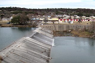
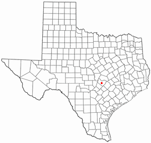
San Saba is a city located in, and the county seat of, San Saba County, Texas, United States. It was settled in 1854 and named for its location on the San Saba River and for Sabbas the Sanctified. Its population was 3,099 at the 2010 census.

<span class="mw-page-title-main">Stratford, Texas</span> Town in Texas, US

Stratford is a town and county seat of Sherman County, Texas, United States. The population was 1,939 at the 2020 census, down from 2,017 in 2010.

<span class="mw-page-title-main">Rollingwood, Texas</span> City in Texas, United States

Rollingwood is a city in Travis County, Texas, United States. Part of the Austin–Round Rock metropolitan area, the population was 1,467 at the 2020 census.

<span class="mw-page-title-main">Selma, Texas</span> City in Bexar, Comal, and Guadalupe counties in Texas, United States

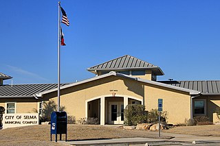
Selma is a city in Bexar, Comal, and Guadalupe counties in Texas, United States. It is part of the San Antonio metropolitan statistical area. Its population was 10,952 at the 2020 census, up from 5,540 at the 2010 census. Selma was settled by German and Polish immigrants in the mid-1800s.

<span class="mw-page-title-main">Uhland, Texas</span> City in Texas, United States

Uhland is a city in Caldwell and Hays counties in the U.S. state of Texas. The population was 1,588 at the 2020 census, up from 1,014 at the 2010 census. Uhland is named after the German poet Ludwig Uhland. Like its neighbor to the north, the city of Niederwald, Uhland was also settled by German emigrants in the 1800s in a region of central Texas known as the Texas-German belt.

References

  1. "2019 U.S. Gazetteer Files". United States Census Bureau. Retrieved August 7, 2020.
  2. 1 2 U.S. Geological Survey Geographic Names Information System: Marion, Texas
  3. 1 2 "U.S. Census website". United States Census Bureau . Retrieved January 31, 2008.
  4. 1 2 "Geographic Identifiers: 2010 Demographic Profile Data (G001): Marion city, Texas". U.S. Census Bureau, American Factfinder. Retrieved March 24, 2017.[ dead link ]
  5. Vivian Elizabeth Smyrl. "MARION, TEXAS". Handbook of Texas Online . Retrieved May 26, 2010.
  6. "Census of Population and Housing". Census.gov. Retrieved June 4, 2015.
  7. "Explore Census Data". data.census.gov. Retrieved May 24, 2022.
  8. https://www.census.gov/ [ not specific enough to verify ]
  9. "About the Hispanic Population and its Origin". www.census.gov. Retrieved May 18, 2022.
  1. Note: the US Census treats Hispanic/Latino as an ethnic category. This table excludes Latinos from the racial categories and assigns them to a separate category. Hispanics/Latinos can be of any race. [8] [9]