Charlotte, Texas | |
---|---|
Coordinates: 28°51′38″N98°42′27″W / 28.86056°N 98.70750°W | |
Country | United States |
State | Texas |
County | Atascosa |
Area | |
• Total | 2.04 sq mi (5.28 km2) |
• Land | 2.04 sq mi (5.28 km2) |
• Water | 0.00 sq mi (0.00 km2) |
Elevation | 541 ft (165 m) |
Population (2010) | |
• Total | 1,715 |
• Estimate (2019) [3] | 1,898 |
• Density | 930.39/sq mi (359.19/km2) |
Time zone | UTC-6 (Central (CST)) |
• Summer (DST) | UTC-5 (CDT) |
ZIP code | 78011 |
Area code | 830 |
FIPS code | 48-14404 [4] |
GNIS feature ID | 1354329 [2] |
Charlotte is a city in Atascosa County, Texas, United States. The population was 1,715 at the 2010 census. [5] It is part of the San Antonio Metropolitan Statistical Area. The town is named for Charlotte Simmons, the daughter of Dr. Charles Simmons, who aided in the development of Atascosa County.
Charlotte is located at 28°51′38″N98°42′27″W / 28.86056°N 98.70750°W (28.860624, –98.707571). [6] This is 52 miles (84 km) south of downtown San Antonio.
According to the United States Census Bureau, the city has a total area of 2.0 square miles (5.2 km2), all land. [5]
The climate in this area is characterized by hot, humid summers and generally mild to cool winters. According to the Köppen Climate Classification system, Charlotte has a humid subtropical climate, abbreviated "Cfa" on climate maps. [7]
Climate data for Charlotte, Texas (5 miles north-northwest) (1981–2010 normals, extremes 1962–2012) | |||||||||||||
---|---|---|---|---|---|---|---|---|---|---|---|---|---|
Month | Jan | Feb | Mar | Apr | May | Jun | Jul | Aug | Sep | Oct | Nov | Dec | Year |
Record high °F (°C) | 93 (34) | 100 (38) | 100 (38) | 107 (42) | 105 (41) | 109 (43) | 106 (41) | 111 (44) | 110 (43) | 107 (42) | 97 (36) | 90 (32) | 111 (44) |
Mean daily maximum °F (°C) | 67.1 (19.5) | 71.0 (21.7) | 77.2 (25.1) | 84.2 (29.0) | 89.4 (31.9) | 93.9 (34.4) | 96.0 (35.6) | 97.1 (36.2) | 91.9 (33.3) | 85.1 (29.5) | 76.1 (24.5) | 67.7 (19.8) | 83.1 (28.4) |
Daily mean °F (°C) | 54.6 (12.6) | 58.3 (14.6) | 64.5 (18.1) | 71.6 (22.0) | 78.3 (25.7) | 82.9 (28.3) | 84.5 (29.2) | 84.9 (29.4) | 80.4 (26.9) | 73.0 (22.8) | 63.9 (17.7) | 55.6 (13.1) | 71.0 (21.7) |
Mean daily minimum °F (°C) | 42.0 (5.6) | 45.6 (7.6) | 51.9 (11.1) | 59.0 (15.0) | 67.1 (19.5) | 71.8 (22.1) | 73.0 (22.8) | 72.8 (22.7) | 68.9 (20.5) | 60.8 (16.0) | 51.8 (11.0) | 43.4 (6.3) | 59.0 (15.0) |
Record low °F (°C) | 14 (−10) | 14 (−10) | 17 (−8) | 28 (−2) | 37 (3) | 55 (13) | 59 (15) | 58 (14) | 44 (7) | 27 (−3) | 20 (−7) | 6 (−14) | 6 (−14) |
Average precipitation inches (mm) | 1.43 (36) | 1.72 (44) | 1.99 (51) | 1.97 (50) | 2.77 (70) | 3.39 (86) | 2.27 (58) | 1.90 (48) | 2.74 (70) | 3.09 (78) | 1.79 (45) | 1.51 (38) | 26.57 (674) |
Average precipitation days (≥ 0.01 in) | 5.4 | 5.4 | 5.6 | 4.5 | 5.7 | 5.5 | 4.4 | 4.1 | 5.0 | 5.5 | 4.3 | 5.0 | 60.4 |
Source: NOAA [8] [9] |
Census | Pop. | Note | %± |
---|---|---|---|
1950 | 1,272 | — | |
1960 | 1,465 | 15.2% | |
1970 | 1,329 | −9.3% | |
1980 | 1,443 | 8.6% | |
1990 | 1,475 | 2.2% | |
2000 | 1,637 | 11.0% | |
2010 | 1,715 | 4.8% | |
2019 (est.) | 1,898 | [3] | 10.7% |
U.S. Decennial Census [10] |
Race | Number | Percentage |
---|---|---|
White (NH) | 211 | 13.85% |
Black or African American (NH) | 5 | 0.33% |
Asian (NH) | 3 | 0.2% |
Some Other Race (NH) | 5 | 0.33% |
Mixed/Multi-Racial (NH) | 16 | 1.05% |
Hispanic or Latino | 1,284 | 84.25% |
Total | 1,524 |
As of the 2020 United States census, there were 1,524 people, 499 households, and 333 families residing in the city.
As of the census [4] of 2000, there were 1,637 people, 514 households, and 401 families residing in the city. The population density was 823.4 inhabitants per square mile (317.9/km2). There were 585 housing units at an average density of 294.3 per square mile (113.6/km2). The racial makeup of the city was 64.94% White, 0.06% African American, 1.65% Native American, 29.93% from other races, and 3.42% from two or more races. Hispanic or Latino of any race were 81.19% of the population.
There were 514 households, out of which 45.1% had children under the age of 18 living with them, 54.3% were married couples living together, 17.1% had a female householder with no husband present, and 21.8% were non-families. 18.7% of all households were made up of individuals, and 10.5% had someone living alone who was 65 years of age or older. The average household size was 3.18 and the average family size was 3.61.
In the city, the population was spread out, with 34.8% under the age of 18, 10.2% from 18 to 24, 27.4% from 25 to 44, 18.0% from 45 to 64, and 9.7% who were 65 years of age or older. The median age was 30 years. For every 100 females, there were 98.9 males. For every 100 females age 18 and over, there were 92.1 males.
The median income for a household in the city was $24,792, and the median income for a family was $27,976. Males had a median income of $24,375 versus $15,313 for females. The per capita income for the city was $9,769. About 24.9% of families and 30.0% of the population were below the poverty line, including 35.1% of those under age 18 and 25.0% of those age 65 or over.
Charlotte is governed by a city council. Council members are elected by the city's voters every two years. The city council has no term limit. [13]
Charlotte is served by the Charlotte Independent School District and home to the Charlotte High School Trojans. According to Guadalupe San Miguel, In Charlotte ISD is where the first official legal complaint regarding racial segregation against Mexicans in Texas took place in 1928. The complaint was filed by Felipe Vela on behalf of his daughter, Amada Vela. Their racial segregation complaint reached the State Board of Education and they sided with the Vela family. [14]
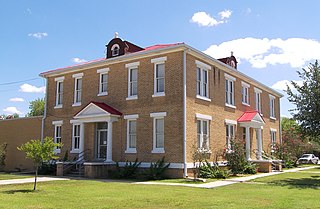
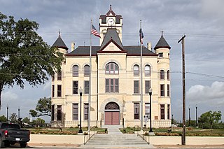
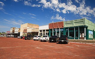
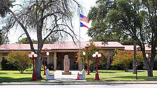
McMullen County is a county located in the U.S. state of Texas. As of the 2020 census, its population was 600, making it the fourth-least populous county in Texas. Its county seat is Tilden. The county was established from parts of Bexar County, Atascosa County, and Live Oak County in 1858 and later organized in 1877. It is named for John McMullen, founder of a colony in Texas. The McMullen County Courthouse was designed by the architect W.C. Stephenson, originally from Buffalo, New York. Stephenson also designed some 50 buildings in Beeville, including the Bee County Courthouse.
Live Oak County is a county in the U.S. state of Texas. It was named for its native groves of live oak. George West is its county seat. Its population was 11,335 in the 2020 census.
Frio County is a county located in the U.S. state of Texas. As of the 2020 census, its population was 18,385. The county seat is Pearsall. The county was created in 1858 and later organized in 1871. Frio is named for the Frio River, whose name is Spanish for "cold".
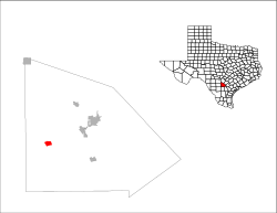
Atascosa County is a county located in the U.S. state of Texas. It is in South Texas and its county seat is Jourdanton.
Jourdanton is a city in and the county seat of Atascosa County, Texas, United States. The population is 4,094. It is part of the San Antonio metropolitan statistical area. The mayor is Robert "Doc" Williams. The city manager is Bobby J. Martinez. The police chief is Eric Kaiser. The fire chief is Jay Fojtik.
Poteet is a city in Atascosa County, Texas, United States. The population was 2,795 as of the 2020 census. It is part of the San Antonio Metropolitan Statistical Area. It was named for its first postmaster, Francis Marion Poteet. It is best known as the birthplace of country music legend George Strait.
Somerset is a city located in Bexar County, Texas, United States. It is located less than 20 miles south of Downtown San Antonio and is part of the San Antonio–New Braunfels metropolitan area. The population was 1,756 at the 2020 census.
Round Mountain is a town in Blanco County, Texas, United States. The population was 181 at the 2010 census.
Meridian is a city and the county seat of Bosque County in central Texas, United States. It is forty-seven miles northwest of Waco. The population was 1,493 at the 2010 census.
Benavides is a city in Duval County, Texas, United States. The population was 1,362 at the 2010 census, down from 1,686 at the 2000 census.
Eastland is a city in Eastland County, Texas, United States. Its population was 3,960 at the 2010 census. It is the county seat of Eastland County.
Itascaeye-TAS-kə is a city in Hill County in Northern Central Texas, United States. As of the 2010 census, the city population was 1,644.
Stinnett is a city in and the county seat of Hutchinson County, Texas, United States. The population was 1,881 at the 2010 census, a decrease from 1,936 at the 2000 census.
Falls City is a city in Karnes County, Texas, United States. The population was 514 at the 2020 census. Falls City is near the location of a uranium tailings disposal cell, completed in 1994 under the terms of the 1978 Uranium Mill Tailings Radiation Control Act. The early settlers, predominantly Polish Catholics, founded the Holy Trinity Catholic Church in 1902.
Three Rivers is a city in Live Oak County, Texas, United States. The population was 1,848 at the 2010 census.
Natalia is a city in Medina County, Texas, United States. The population was 1,202 at the 2020 census. It was founded in 1912 and was named after Natalie Pearson Nicholson, daughter of Frederick Stark Pearson, engineer, designer and builder of the Medina Dam.
Lytle is a city in Atascosa, Bexar, and Medina counties in the U.S. state of Texas. The population was 2,492 at the 2010 census. It is part of the San Antonio Metropolitan Statistical Area.
Horseshoe Bay is a city in Llano and Burnet counties in the U.S. state of Texas.
San Diego is a city in Duval and Jim Wells counties, Texas, United States. The population was 3,748 at the 2020 census and 4,488 at the 2010 census. It is located primarily in Duval County, of which it is the county seat.
Gorman is a city in Eastland County, Texas, United States. Its population was 1,083 at the 2010 census, down from 1,236 at the 2000 census.