
Medina County is a county located in the U.S. state of Texas. As of the 2020 census, its population was 50,748. Its county seat is Hondo. The county is named for the Medina River. The extreme northern part of the county lies within the Edwards Plateau, which elevates into the Texas Hill Country. The Medina Dam, the fourth largest in the nation when completed in 1913, is listed on the National Register of Historic Places. The irrigation project, creating Medina Lake, was built by 1500 skilled workers who worked in shifts operating 24 hours a day to complete the dam in two years. Medina County is part of the San Antonio, TX Metropolitan Statistical Area.
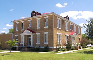
McMullen County is a county located in the U.S. state of Texas. As of the 2020 census, its population was 600, making it the fourth-least populous county in Texas. Its county seat is Tilden. The county was established from parts of Bexar County, Atascosa County, and Live Oak County in 1858 and later organized in 1877. It is named for John McMullen, founder of a colony in Texas. The McMullen County Courthouse was designed by the architect W.C. Stephenson, originally from Buffalo, New York. Stephenson also designed some 50 buildings in Beeville, including the Bee County Courthouse.

Atascosa County is a county located in the U.S. state of Texas. It is in South Texas and its county seat is Jourdanton.

Lytle is a city in Atascosa, Bexar, and Medina counties in the U.S. state of Texas. The population was 2,492 at the 2010 census. It is part of the San Antonio Metropolitan Statistical Area.
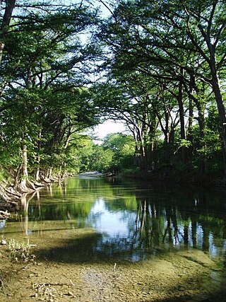
The Medina River is located in south central Texas, United States, in the Medina Valley. It was also known as the Rio Mariano, Rio San Jose, or Rio de Bagres. Its source is in springs in the Edwards Plateau in northwest Bandera County, Texas and merges with the San Antonio River in southern Bexar County, Texas, for a course of 120 miles. It contains the Medina Dam in NE Medina County, Texas which restrains Lake Medina. Much of its course is owned and operated by the Bexar-Medina-Atascosa Water District to provide irrigation services to farmers and ranchers.

The Alamo Area Council of Governments (AACOG) is a voluntary association of cities, counties and special districts in the south-central region of the U.S. state of Texas.
Somerset Independent School District is a public school district based in Somerset, Texas (USA).

Greater San Antonio, officially designated San Antonio–New Braunfels, is an eight-county metropolitan area in the U.S. state of Texas defined by the Office of Management and Budget (OMB). The metropolitan area straddles South Texas and Central Texas and is on the southwestern corner of the Texas Triangle. The official 2020 U.S. census showed the metropolitan area's population at 2,558,143—up from a reported 1,711,103 in 2000—making it the 24th largest metropolitan area in the United States. Austin–Round Rock lies about 80 mi (130 km) northeast of Greater San Antonio.
The Alamo Colleges District is a network of five community colleges in San Antonio and Universal City, Texas, and serving the Greater San Antonio metropolitan area. The district was founded in 1945 as the San Antonio Union Junior College District before adopting the Alamo name in 1982.
Atascosa is an unincorporated community located in southwestern Bexar County, Texas, United States. According to the Handbook of Texas, the community had a population of 300 in 2000. The community is part of the San Antonio Metropolitan Statistical Area.
McCoy is an unincorporated community in Atascosa County, Texas, United States. According to the Handbook of Texas, the community had a population of 30 in 2000. It is located within the San Antonio metropolitan area.
Amphion is an unincorporated community in Atascosa County, in the U.S. state of Texas. According to the Handbook of Texas, the community had a population of 26 in 2000. It is located within the San Antonio metropolitan area.
Anchorage is an unincorporated community in Atascosa County, in the U.S. state of Texas. It is located within the San Antonio metropolitan area.
Davis, also known as Davistown or Davis Switch, is an unincorporated community in Atascosa County, in the U.S. state of Texas. According to the Handbook of Texas, the community had a population of 8 in 2000. It is located within the San Antonio metropolitan area.
Iuka is an unincorporated community in Atascosa County, in the U.S. state of Texas. It is located within the San Antonio metropolitan area.
Verdi is an unincorporated community in Atascosa County, in the U.S. state of Texas. According to the Handbook of Texas, the community had a population of 110 in 2000. It is located within the San Antonio metropolitan area.
Dobrowolski is a ghost town in Atascosa County, in the U.S. state of Texas. According to the Handbook of Texas, the community had a population of 10 in 2000. It is located within the San Antonio metropolitan area.
Bexar is an unincorporated community in Bexar County, in the U.S. state of Texas. It is located within the Greater San Antonio metropolitan area.


